Trellech facts for kids
Quick facts for kids Trellech
|
|
|---|---|
 Trellech from the air |
|
| OS grid reference | SO500054 |
| Community |
|
| Principal area | |
| Ceremonial county | |
| Country | Wales |
| Sovereign state | United Kingdom |
| Post town | MONMOUTH |
| Postcode district | NP25 |
| Dialling code | 01600 |
| Police | Gwent |
| Fire | South Wales |
| Ambulance | Welsh |
| EU Parliament | Wales |
| UK Parliament |
|
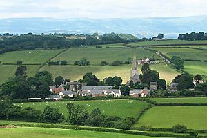
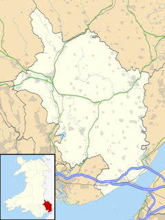
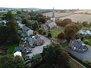
Trellech (also spelled Trelech, Treleck, or Trelleck; Welsh: Tryleg) is a small village and parish in Monmouthshire, south-east Wales. It is located about 5 miles (8 km) south of Monmouth and 4 miles (6.4 km) north-north-west of Tintern. Trellech sits on a flat area of land high above the Wye Valley. It is surrounded by woodlands, which are part of an Area of Outstanding Natural Beauty.
In the village, you can find three ancient standing stones from the Bronze Age. They are called Harold's Stones. These stones look over the historic Church of St Nicholas, which is a very important Grade I listed building.
Even though Trellech is a small village today, it was once one of the biggest towns in Wales during the 13th century. Today, it is an important place for archaeologists to study. They want to learn more about how big it was and what its role was back then. The village is also a special conservation area.
There are four nature reserves close by. New Grove Flower Meadow is famous for its orchids. Trellech Beacon is also owned by Gwent Wildlife Trust. Cleddon Bog and Croes Robert Wood are both special scientific sites (SSSI).
Contents
What Does the Name Trellech Mean?
The Welsh name Tryleg probably means 'conspicuous stone' or 'noticeable stone'. It comes from an old Welsh word for 'stone' or 'slab'. This name might refer to a large stone that once stood on a hill about a mile and a half north of the village.
Over time, the name has been spelled in many different ways. In the past, there were up to 30 different spellings! Today, you might see Trellech, Trelleck, or Trelech on signs when you enter the village. The way the name is pronounced in English is different from how it would be in Welsh.
Trellech's Past: A Look Back in Time
Trellech was a very important town in medieval Wales. Archaeologists have been digging here for many years to uncover its secrets. It is believed that the powerful De Clare family started the town. They wanted to use the local iron ore from the Forest of Dean and charcoal from the nearby woods. These materials were used to make weapons, armor, and other iron items for their military campaigns in Wales, like building Caerphilly Castle.
By 1288, Trellech had 378 plots of land for houses, called burgage plots. This made it bigger than cities like Cardiff or Chepstow at that time! However, Trellech was mostly destroyed in 1291 after a fight over deer hunting. Later, the terrible Black Death plague hit in the 1340s and 1350s. Then, Owain Glyndŵr and his men caused more damage in the early 15th century. All these events made Trellech much less important.
Exploring Trellech: Archaeological Discoveries
Archaeological digs in Trellech have been happening since the early 1990s. Experts from the University of Wales, Newport have led these investigations. There is some discussion among archaeologists about how the medieval town was laid out.
In 2005, an archaeologist named Stuart Wilson bought a field. He was sure that the remains of the lost medieval town were hidden there. His interest in this field was even featured in a BBC Radio 4 documentary called The Boy Who Bought a Field. The program showed that Wilson had found medieval walls and old paving.
By 2008, the Monmouth Archaeological Society agreed that the main part of the medieval town was likely in the farmland south of the current village. In 2016, Wilson suggested turning the site into a research center and tourist spot.
Historic Places to Visit in Trellech
St Nicholas' Church: A Village Landmark
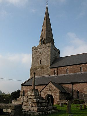
The Anglican parish church of St Nicholas is a very important building. It has been a Grade I listed building since 1953. One historian described it as "one of the largest and most handsome of the country churches" in Monmouthshire. It has a tall, pointed steeple that can be seen for miles around. The church also has an old font and a 17th-century sundial.
The church is mostly built from local red sandstone. Its spire is a proud symbol of the village. An earlier church, probably made of wood, stood here in the 7th and 8th centuries. The stone building you see today was built in the 13th or early 14th century. Its Gothic stonework dates from between 1225 and 1272.
Inside, the church has a large main area called a nave and a smaller chancel. The altar rails and pulpit from 1640 are still there. At the back of the church, you can see a Royal Coat of Arms for King Charles II from 1683. The church has records going back to 1692.
The Church Sundial
Inside the church, there is an old stone sundial from 1689. It was originally set up by Lady Probert. Three sides of the sundial show important historical features of the village:
- Tump Terret: With words meaning "Great in its Mound" and "Oh! How many are buried here."
- Harold's Stones: With words meaning "Greater in its Stones" and "Here Harold was victorious."
- The Virtuous Well: With words meaning "Greatest in its Well" and "Lady Magdalen Probert gives proof of it."
The sundial used to be in a garden on top of an old font. Both were moved inside the church in the early 1900s.
Harold's Stones: Ancient Mysteries
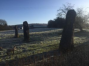
Three huge stones, made of a rock called puddingstone, stand in a field south of the village. These stones are known as Harold's Stones. They are on land that is open to the public and are a protected ancient monument. They are considered one of the most important ancient stone monuments in Monmouthshire.
These stones are believed to be from the Bronze Age. Such ancient remains are rare in this part of Wales. Many local stories are told about them:
- Some say they were put up by Harold Godwinson to celebrate a victory in 1063.
- Others believe they honor three leaders who died fighting the Romans.
- Another story says they were thrown from the Skirrid mountain by the mythical Jack o' Kent in a contest with the Devil.
The stones are lined up roughly from north-east to south-west. This might mean they were used to mark the midwinter sunset or midsummer sunrise. The stones are 2.7 meters (9 ft), 3.7 meters (12 ft), and 4.6 meters (15 ft) tall. The tallest one is at the south-west end. The middle stone has small hollows, called cup marks, carved into it.
Experts think these stones were dragged to the site on logs and then lifted into place. They might have been used to track the seasons or for religious ceremonies. Similar short rows of stones were built by communities in Ireland, Britain, and Brittany during the Bronze Age, between 1800 and 1000 BC.
Tump Terret and Court Farm
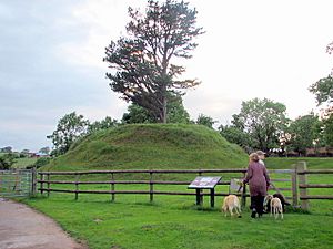
Tump Terret is a mound located on the grounds of Court Farm, southwest of the church. It dates back to Norman times. It was once the site of a small motte and bailey castle, which was a type of early castle built on a mound. You can still see traces of the ditch that surrounded it. The castle was still standing in 1263.
A local legend says that Tump Terret is a burial mound for those who died in battles between Harold Godwinson's forces and the Welsh.
The Virtuous Well: A Healing Spring
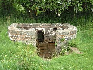
This circular wellspring is sometimes called St Anne's Well. It is surrounded by a stone wall and seating. You can find it in a field about 400 yards (366 m) east of the village, on the road to Tintern. People in the past believed it was one of nine holy wells in Trellech.
In the 17th century, many people visited this well. They believed its water could cure illnesses like scurvy and colic. The water from the well is rich in iron.
The Virtuous Well is a clootie well. This means people leave small offerings around and inside the well. You might see strips of cloth and ribbons hanging from nearby trees. It is also used as a wishing well. Traditionally, if you threw a small metal object into the water, many bubbles meant your wish would come true quickly. Few bubbles meant a long wait, and no bubbles meant the wish would not be granted.
The Village Hall: The Babington Centre
The building that is now the Trellech Village Hall, also known as The Babington Centre, was built in 1820. It first served as a primary school. A school was originally set up in the village in 1591. Later, in 1691, a new school was started by the local vicar, Zachary Babington. He created a charity to help poor children in the village get an education.
When the primary school moved to a new location, the 1820 building became the property of the Trellech Babington Educational Trust. Today, The Babington Centre is a hub for village life. It hosts film nights, concerts, educational classes, and other social events.
The Lion Inn: A Historic Pub
The Lion Inn was built in the late 16th century, around 1580. It is a Grade II listed building, meaning it is historically important. It started as a coaching inn, a place where travelers could stop, eat, and rest their horses. It also had a brew house and a pig farm. Many of the original features of the brewing cellar are still there.
The Lion Inn has won awards for its real ales. It hosts fun events like an annual beer festival and a cider and perry festival. They also have 'Open Mic' nights every other Monday.
Famous People from Trellech
- Bertrand Russell (1872–1970): This famous philosopher, logician, and mathematician was born at Cleddon Hall, near Trellech.
- Kate Humble: The well-known television presenter lives and farms in Trellech.
 | Jewel Prestage |
 | Ella Baker |
 | Fannie Lou Hamer |


