
Tunbridge, Vermont facts for kids
Quick facts for kids
Tunbridge, Vermont
|
|
|---|---|
|
Town
|
|

Tunbridge town office
|
|

Located in Orange County, Vermont
|
|

Tunbridge, Vermont
Location in the United States
|
|
| Country | United States |
| State | Vermont |
| County | Orange |
| Chartered | 1761 |
| Settled | 1776 |
| Organized | 1786 |
| Communities | Tunbridge North Tunbridge South Tunbridge |
| Area | |
| • Total | 44.8 sq mi (115.9 km2) |
| • Land | 44.7 sq mi (115.9 km2) |
| • Water | 0.04 sq mi (0.1 km2) 0.09% |
| Elevation | 600 ft (172 m) |
| Population
(2020)
|
|
| • Total | 1,337 |
| • Density | 30/sq mi (11.5/km2) |
| • Households | 548 |
| • Families | 343 |
| Time zone | UTC-5 (EST) |
| • Summer (DST) | UTC-4 (EDT) |
| ZIP Codes | |
| Area code(s) | 802 |
| FIPS code | 50-73675 |
| GNIS feature ID | 1462231 |
Tunbridge is a small town located in Orange County, Vermont, United States. As of 2020, about 1,337 people live there. The town has three main communities: North Tunbridge, Tunbridge Village, and South Tunbridge. These communities are all found along Vermont Route 110, in the valley of the First Branch of the White River.
Contents
Exploring Tunbridge's Historic Sites
Tunbridge is known for its many historic places. The entire center of Tunbridge Village, including its famous fairgrounds, was added to the National Register of Historic Places in 1994. This means these areas are officially recognized for their historical importance.
What are Tunbridge's Covered Bridges?
Tunbridge is home to five beautiful covered bridges, all of which are also listed on the National Register of Historic Places. These bridges are a special part of the town's history and charm.
- Cilley Bridge – Located southwest of Tunbridge Village.
- Flint Bridge – Found in North Tunbridge.
- Larkin Bridge – Also in North Tunbridge.
- Howe Bridge – South of Tunbridge Village.
- Mill (or Hayward & Noble or Spring Rd.) Bridge – Right in Tunbridge Village.
Other Important Historic Buildings
Besides the covered bridges, two other buildings in Tunbridge are individually listed on the National Register:
- Hayward & Kibby (or Hayward & Noble) Mill – An old mill located on Spring Road in Tunbridge Village.
- South Tunbridge Methodist Episcopal Church – A historic church building.
Discovering the Tunbridge World's Fair
The Tunbridge World's Fair is a very old and popular event. Its history goes all the way back to the town's original charter in 1761. This charter allowed for two yearly fairs once the town had 50 families.
How the Fair Began
The first official fair was held in 1867 by the Tunbridge Agricultural Society. It took place at the Elisha Lougee Farm in North Tunbridge. At this fair, a former Lieutenant Governor of Vermont called it a "little World's Fair." This name stuck, and the fair has been known as the Tunbridge World's Fair ever since.
In 1875, the Union Agricultural Society took over the fair. They moved it to its current location in the center of Tunbridge.
What Can You See at the Fair?
The Tunbridge World's Fair still happens every year. It celebrates farming and agricultural traditions. You can see:
- Demonstrations of old farming methods.
- Antique displays that still work.
- Horse and ox pulling contests.
- Horse racing on Vermont's only remaining grass racetrack.
- Cattle and horse shows.
- Exhibits from young people, like 4-H projects.
- Floral displays.
- Traditional contra dancing.
- Gymkhana (horse riding games).
- Many free shows and performances.
Understanding Tunbridge's Geography and Land

Tunbridge covers about 44.8 square miles (115.9 square kilometers). Most of this area is land, with a very small amount of water.
Rivers and Springs
The First Branch of the White River flows through Tunbridge from north to south. It divides the town into two almost equal parts. There are also two mineral springs in the town. One is a white sulfur spring on "Spring Road," which was once thought to have healing powers.
Hills and Soil
The highest points in Tunbridge include Brocklebank Hill (over 2,100 feet), Old Hurricane Hill (over 1,900 feet), and East Hill (2,112 feet).
The soil in Tunbridge is well-drained. It was formed from glacial till, which is material left behind by glaciers. This soil is usually 20 to 40 inches deep. It's known as the Tunbridge Soil Series and is the official State Soil of Vermont. It's great for farming and growing trees.
Trees and Plants
You can find many types of trees in Tunbridge, such as:
- White birch and yellow birch.
- American beech.
- Red spruce.
- Red maple and sugar maple.
- White ash.
- Hemlock.
- White pine.
Tunbridge's Population and People
| Historical population | |||
|---|---|---|---|
| Census | Pop. | %± | |
| 1790 | 487 | — | |
| 1800 | 1,314 | 169.8% | |
| 1810 | 1,640 | 24.8% | |
| 1820 | 2,003 | 22.1% | |
| 1830 | 1,920 | −4.1% | |
| 1840 | 1,811 | −5.7% | |
| 1850 | 1,786 | −1.4% | |
| 1860 | 1,546 | −13.4% | |
| 1870 | 1,405 | −9.1% | |
| 1880 | 1,252 | −10.9% | |
| 1890 | 1,011 | −19.2% | |
| 1900 | 885 | −12.5% | |
| 1910 | 918 | 3.7% | |
| 1920 | 907 | −1.2% | |
| 1930 | 903 | −0.4% | |
| 1940 | 882 | −2.3% | |
| 1950 | 774 | −12.2% | |
| 1960 | 743 | −4.0% | |
| 1970 | 791 | 6.5% | |
| 1980 | 925 | 16.9% | |
| 1990 | 1,154 | 24.8% | |
| 2000 | 1,309 | 13.4% | |
| 2010 | 1,284 | −1.9% | |
| 2020 | 1,337 | 4.1% | |
| U.S. Decennial Census | |||
As of the year 2000, there were 1,309 people living in Tunbridge. There were 513 households and 362 families. The population density was about 29.3 people per square mile.
Who Lives in Tunbridge?
Most of the people living in Tunbridge are White (99.01%). A small percentage are African American, Native American, or Asian. About 0.99% of the population identified as Hispanic or Latino.
In 2000, about 31% of households had children under 18 living with them. The average household had about 2.55 people. The average family had about 2.94 people.
Age and Education
The population in Tunbridge is spread out by age:
- 25.4% were under 18 years old.
- 31.5% were between 25 and 44 years old.
- 13.2% were 65 years or older.
The average age in Tunbridge was 38 years old.
Most adults in Tunbridge have a high school education or higher (84.9%). About 25.8% have a bachelor's degree or higher.
Famous People from Tunbridge
Many interesting people have connections to Tunbridge:
- Sarah E. Buxton – A member of the Vermont House of Representatives.
- David M. Camp – Served as Lieutenant Governor of Vermont from 1836 to 1841.
- Susan Dollenmaier – The founder of ANICHINI, Inc., a company known for luxury textiles.
- Frank A. Haskell – A colonel in the Union Army during the Civil War. He wrote an important account of the Battle of Gettysburg.
- Harry David Lee – The person who started Lee Jeans.
- Solomon Mack – A veteran of the French and Indian War and the American Revolution. He was the grandfather of Joseph Smith Jr..
- Stephen Mack – A merchant and politician.
- Ivy Mix – A famous bartender known for making mezcal popular in the United States.
- John O'Brien – A filmmaker and director.
- Hyrum Smith – An important leader in the early Latter Day Saint movement.
- Joseph Smith Sr. – The father of Joseph Smith Jr. and the first Presiding Patriarch in the Latter Day Saint movement.
- Samuel Harrison Smith – A missionary.
- Fred Tuttle – A farmer who became a movie actor and even ran for political office.
Images for kids
-
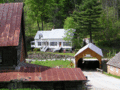
Hayward and Noble Mill, and Mill Bridge

See also
 In Spanish: Tunbridge (Vermont) para niños
