
Tyringham, Massachusetts facts for kids
Quick facts for kids
Tyringham, Massachusetts
|
||
|---|---|---|

Santarella, the home of Henry Hudson Kitson
|
||
|
||

Location in Berkshire County and the state of Massachusetts.
|
||
| Country | United States | |
| State | Massachusetts | |
| County | Berkshire | |
| Settled | 1735 | |
| Incorporated | 1762 | |
| Government | ||
| • Type | Open town meeting | |
| Area | ||
| • Total | 18.9 sq mi (48.9 km2) | |
| • Land | 18.6 sq mi (48.3 km2) | |
| • Water | 0.2 sq mi (0.6 km2) | |
| Elevation | 901 ft (275 m) | |
| Population
(2020)
|
||
| • Total | 427 | |
| • Density | 22.62/sq mi (8.732/km2) | |
| Time zone | UTC-5 (Eastern) | |
| • Summer (DST) | UTC-4 (Eastern) | |
| ZIP code |
01264
|
|
| Area code(s) | 413 | |
| FIPS code | 25-71095 | |
| GNIS feature ID | 0619429 | |

Tyringham is a small and quiet town located in Berkshire County, Massachusetts, United States. It's part of the wider Pittsfield area. In 2020, about 427 people lived here.
Contents
Tyringham's Past
Tyringham began as a settlement called Housatonic Township Number 1. People first moved here in 1735. The town was officially created in 1739. The early villages grew around two waterways: Hop Brook in the north and the Konkapot River in the south.
How Tyringham Got Its Name
In 1762, the town became officially recognized. There are two ideas about how Tyringham got its name. Some say it was named after a village called Tyringham in England. Others believe it was named by Sir Francis Bernard, a former governor of Massachusetts. He might have named it after a woman named Jane Beresford. If this is true, Tyringham would be the only town in Massachusetts named after a woman!
Shakers and Other Towns
Tyringham was once home to the Tyringham Shaker Settlement Historic District. The Shakers were a religious group who called their settlement "Jerusalem." This area was just south of the town center. Later, in 1847, the town of Monterey separated from Tyringham and became its own town.
Famous Rakes and Celebrations
In August 1939, Tyringham celebrated its 200th birthday with a big two-day party and a parade. The Stedman Rake Factory in Tyringham was quite famous. It made rakes for several U.S. Presidents, including Theodore Roosevelt and Herbert Hoover! Today, Tyringham is still a small, peaceful rural community.
Early Economy and Work
Tyringham started with farming. Soon, people also began making things at home and in small factories. In 1786, the town had many houses, shops, and mills. People made cider, and farmers raised horses, pigs, oxen, and cows.
By 1837, sheep farming became popular, with many Merino sheep raised for wool. Factories made boots, shoes, iron items, forks, and even paper. A paper mill was the biggest business, employing many people. The Shakers also had a successful rake factory. After the Shakers left in 1875, their businesses closed. Some of their buildings became a summer resort called Fernside.
Tyringham's Location

Tyringham covers about 48.9 square kilometers (18.9 square miles). Most of this is land, with a small amount of water. The town is shaped like a square. It shares borders with Lee to the north, Becket and Otis to the east, Monterey to the south, and Great Barrington to the west. Tyringham is about 16 miles south of Pittsfield and 125 miles west of Boston.
Tyringham is nestled in the Hop Brook Valley within the beautiful Berkshire Hills. To the northeast, Baldy Mountain rises to a large flat area that extends into nearby towns. To the southwest, Mount Wilcot and Hunger Mountain also rise up.
The Appalachian Trail
The famous Appalachian Trail hiking path goes right through Tyringham. This shows how remote and natural the area is. The trail goes over Sky Hill, through the valley near Main Road, past the town center, and then up Baldy Mountain. There's even a special phone for hikers near the Post Office. Some friendly locals on Main Road sometimes offer hikers a place to stay or a hot shower!
Weather in Tyringham
Tyringham usually has cool weather, with temperatures often below 50°F for more than half the year. It gets a lot of rain, about 46.3 inches per year, which is quite high for the U.S. Snow covers the ground for about 69 days each year.
Who Lives in Tyringham
| Historical population | ||
|---|---|---|
| Year | Pop. | ±% |
| 1850 | 821 | — |
| 1860 | 730 | −11.1% |
| 1870 | 557 | −23.7% |
| 1880 | 542 | −2.7% |
| 1890 | 412 | −24.0% |
| 1900 | 386 | −6.3% |
| 1910 | 382 | −1.0% |
| 1920 | 267 | −30.1% |
| 1930 | 246 | −7.9% |
| 1940 | 213 | −13.4% |
| 1950 | 235 | +10.3% |
| 1960 | 197 | −16.2% |
| 1970 | 234 | +18.8% |
| 1980 | 344 | +47.0% |
| 1990 | 369 | +7.3% |
| 2000 | 350 | −5.1% |
| 2010 | 327 | −6.6% |
| 2020 | 427 | +30.6% |
| 2022* | 421 | −1.4% |
| * = population estimate. Source: United States Census records and Population Estimates Program data. |
||
In 2000, there were 350 people living in Tyringham. The town is one of the smallest in Berkshire County and in Massachusetts. Most residents were White, with smaller numbers of Asian, African American, and Native American people. About a quarter of households had children under 18. The average age of people in Tyringham was 48 years old.
Learning in Tyringham
Students from Tyringham go to schools in the nearby town of Lee. Lee Elementary School teaches students from pre-kindergarten to sixth grade. Lee Middle and High School serves students from seventh to twelfth grades. There's also a private school, Saint Mary's School, in Lee. Other private schools are available in surrounding towns like Great Barrington.
Places to Visit
- Santarella, also known as "The Gingerbread House," was the home of sculptor Henry Hudson Kitson.
- Tyringham Shaker Settlement Historic District is a historic area where the Shakers once lived.
- Ashintully Gardens offers beautiful outdoor spaces to explore.
- Tyringham Cobble is a popular spot for hiking and enjoying nature.
Famous People from Tyringham
Many interesting people have lived in or visited Tyringham:
- Brooke Astor once owned a home here.
- Grover Cleveland, a U.S. President, enjoyed fishing in Hop Brook. He was even fined once for catching too many fish!
- Maria Cole, the wife of singer Nat "King" Cole, moved to Tyringham.
- Kitty Dukakis and her husband, former governor Michael Dukakis, had a vacation home here.
- George Gilder, a writer and economist, spent most of his childhood in Tyringham and still lives there.
- Rutherford B. Hayes, another U.S. President, spent a summer in Tyringham.
- Sidney Howard, a playwright and screenwriter who wrote for the movie Gone with the Wind, lived and died in Tyringham.
- Yo-Yo Ma, the famous classical musician, has a home in Tyringham.
- William Roerick, an actor, lived at his "Lost Farm" homestead. The writer E. M. Forster even dedicated a book to him and the farm.
- Mark Twain, the famous writer, often visited Tyringham. He spent a summer here after his daughter passed away.
- Sir Brian Urquhart, a British diplomat and United Nations official, lived and died in the town.
Images for kids
-
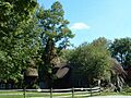
Santarella, the home of Henry Hudson Kitson
-
Seal of Tyringham, Massachusetts
-
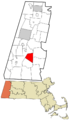
Location in Berkshire County and the state of Massachusetts.
See also
 In Spanish: Tyringham (Massachusetts) para niños
