Wallace County, Kansas facts for kids
Quick facts for kids
Wallace County
|
|
|---|---|

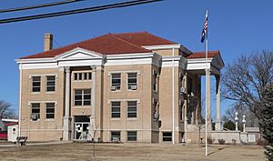
Wallace County Courthouse in Sharon Springs (2010)
|
|

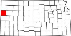
Location within the U.S. state of Kansas
|
|
 Kansas's location within the U.S. |
|
| Country | |
| State | |
| Founded | 1868 |
| Named for | W. H. L. Wallace |
| Seat | Sharon Springs |
| Largest city | Sharon Springs |
| Area | |
| • Total | 914 sq mi (2,370 km2) |
| • Land | 914 sq mi (2,370 km2) |
| • Water | 0.05 sq mi (0.1 km2) 0.01% |
| Population
(2020)
|
|
| • Total | 1,512 |
| • Estimate
(2021)
|
1,508 |
| • Density | 1.7/sq mi (0.7/km2) |
| Time zone | UTC−7 (Mountain) |
| • Summer (DST) | UTC−6 (MDT) |
| Congressional district | 1st |
Wallace County is a county in the state of Kansas. Its main town, called the county seat, is Sharon Springs.
In 2020, about 1,512 people lived here. This makes it the second-smallest county in Kansas by population. The county was created in 1868. It was named after Brigadier General W.H.L. Wallace. He was a brave soldier who was hurt in a battle.
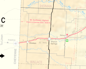
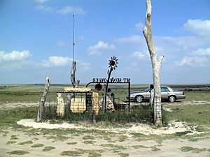
Wallace County is also home to Mount Sunflower. This is the highest point in all of Kansas! It is about 4,039 feet (1,231 meters) high. Mount Sunflower is close to the Colorado state line. Wallace County is special because it uses the Mountain Time Zone. Most of Kansas uses the Central Time Zone.
Contents
History of Wallace County
Early Kansas History
For thousands of years, the Great Plains of North America were home to nomadic Native American tribes.
From the 1500s to the 1700s, France claimed large parts of North America. In 1762, after a war, France secretly gave this land to Spain.
Kansas in the 1800s
In 1802, Spain gave most of the land back to France. Then, in 1803, the United States bought a huge area from France. This was part of the Louisiana Purchase. Most of what is now Kansas was included in this deal.
In 1854, the Kansas Territory was set up. Later, in 1861, Kansas became the 34th U.S. state. Finally, in 1868, Wallace County was officially created.
Geography of Wallace County
Wallace County covers about 914 square miles (2,367 square kilometers). Almost all of this area is land. Only a tiny bit is water.
Neighboring Counties
Wallace County shares borders with several other counties:
- Sherman County (north)
- Logan County (east)
- Wichita County (southeast)
- Greeley County (south)
- Cheyenne County, Colorado (west)
- Kit Carson County, Colorado (northwest)
People of Wallace County

| Historical population | |||
|---|---|---|---|
| Census | Pop. | %± | |
| 1870 | 538 | — | |
| 1880 | 686 | 27.5% | |
| 1890 | 2,468 | 259.8% | |
| 1900 | 1,178 | −52.3% | |
| 1910 | 2,759 | 134.2% | |
| 1920 | 2,424 | −12.1% | |
| 1930 | 2,882 | 18.9% | |
| 1940 | 2,216 | −23.1% | |
| 1950 | 2,508 | 13.2% | |
| 1960 | 2,069 | −17.5% | |
| 1970 | 2,215 | 7.1% | |
| 1980 | 2,045 | −7.7% | |
| 1990 | 1,821 | −11.0% | |
| 2000 | 1,749 | −4.0% | |
| 2010 | 1,485 | −15.1% | |
| 2020 | 1,512 | 1.8% | |
| 2023 (est.) | 1,509 | 1.6% | |
| U.S. Decennial Census 1790-1960 1900-1990 1990-2000 2010-2020 |
|||
In 2000, there were 1,749 people living in Wallace County. There were 674 households, which are groups of people living together. The population density was about 2 people per square mile.
Most people in the county were White (94.63%). Other groups included Black or African American, Native American, and Asian. About 4.80% of the population was Hispanic or Latino.
Many households (33.80%) had children under 18 living with them. Most households (63.60%) were married couples. About 27.60% of households were single individuals.
The average age in the county was 40 years old. About 29.10% of the people were under 18. About 18.10% were 65 or older.
The average income for a household was $33,000 per year. For families, it was $42,022. About 16.10% of the people lived below the poverty line. This included 24.50% of those under 18.
Education in Wallace County
Local School Districts
Wallace County has two main school districts:
- Wallace County USD 241
- Weskan USD 242
Communities in Wallace County
Here are the different types of communities in Wallace County:
Cities
- Sharon Springs (This is the county seat, the main town)
- Wallace
Unincorporated Communities
- Weskan (This community is not officially a city)
Townships
Wallace County is divided into four areas called townships. These townships include the populations of the cities within them.
| Township | Population center |
Population | Population density /km2 (/sq mi) |
Land area km2 (sq mi) |
Water area km2 (sq mi) |
Water % | Geographic coordinates |
|---|---|---|---|---|---|---|---|
| Harrison | 85 | 0 (1) | 210 (81) | 0 (0) | 0% | 38°45′53″N 101°34′34″W / 38.76472°N 101.57611°W | |
| Sharon Springs | Sharon Springs | 1,096 | 1 (3) | 885 (342) | 0 (0) | 0% | 38°54′12″N 101°45′3″W / 38.90333°N 101.75083°W |
| Wallace | Wallace | 175 | 0 (1) | 488 (188) | 0 (0) | 0.01% | 38°58′15″N 101°33′35″W / 38.97083°N 101.55972°W |
| Weskan | Weskan | 393 | 1 (1) | 784 (303) | 0 (0) | 0.01% | 38°53′8″N 101°56′10″W / 38.88556°N 101.93611°W |
See also
 In Spanish: Condado de Wallace para niños


