Washington County, North Carolina facts for kids
Quick facts for kids
Washington County
|
|||
|---|---|---|---|

Washington County Courthouse
|
|||
|
|||
| Nickname(s):
Bear-Olina
|
|||
| Motto(s):
"Where traffic ends and adventure begins."
|
|||

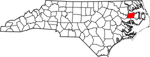
Location within the U.S. state of North Carolina
|
|||
 North Carolina's location within the U.S. |
|||
| Country | |||
| State | |||
| Founded | 1799 | ||
| Named for | George Washington | ||
| Seat | Plymouth | ||
| Largest community | Plymouth | ||
| Area | |||
| • Total | 421.91 sq mi (1,092.7 km2) | ||
| • Land | 346.51 sq mi (897.5 km2) | ||
| • Water | 75.40 sq mi (195.3 km2) 17.87% | ||
| Population
(2020)
|
|||
| • Total | 11,003 | ||
| • Estimate
(2023)
|
10,713 |
||
| • Density | 26.0790/sq mi (10.0692/km2) | ||
| Time zone | UTC−5 (Eastern) | ||
| • Summer (DST) | UTC−4 (EDT) | ||
| Congressional district | 1st | ||
Washington County is a place in North Carolina, USA. In 2020, about 11,000 people lived there. Its main town, or county seat, is Plymouth. The county was created in 1799 from part of Tyrrell County. It was named after George Washington, a very important leader.
Contents
History of Washington County
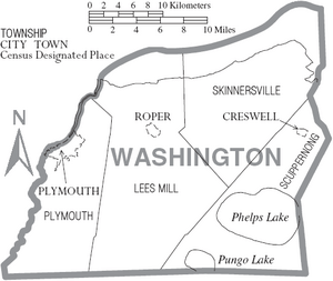
Washington County has three main towns. Plymouth is the county seat. The other towns are Roper and Creswell. This area is known for its rich farmland and many forests. It also has lots of water for public use. The Roanoke River and Albemarle Sound form its northern border.
Lake Phelps is a huge lake, about 16,000 acres. It is part of Pettigrew State Park in Creswell. You can also visit Somerset Place there. It is a restored old plantation and a North Carolina Historic Site near Lake Phelps.
The Pungo Unit of the Pocosin Lakes National Wildlife Refuge is in the southern part of the county. It is a great place to see black bears. This part of North Carolina is famous for having some of the world's largest black bears. It also has many bears living there. Every year, the award-winning NC Black Bear Festival happens in Plymouth. It takes place on the first weekend in June.
Geography of Washington County
Washington County covers about 422 square miles. Most of this area is land, about 347 square miles. The rest, about 75 square miles, is water. The county is next to the Albemarle Sound.
Protected Natural Areas
- Pocosin Lakes National Wildlife Refuge (part of it is in the county)
State and Local Sites
- Bachelor Bay Game Land (part)
- Lantern Acres Game Land (part)
- Latham House
- Pettigrew State Park (part)
- Somerset Place
- Van Swamp Game Lands (part)
Major Water Bodies
Neighboring Counties
- Chowan County – to the north
- Perquimans County – to the northeast
- Tyrrell County – to the east
- Hyde County – to the southeast
- Beaufort County – to the southwest
- Martin County – to the west
- Bertie County – to the northwest
Main Roads
 US 64
US 64 NC 32
NC 32 NC 37
NC 37 NC 45
NC 45 NC 94
NC 94 NC 99
NC 99 NC 149
 NC 308
People of Washington County
| Historical population | |||
|---|---|---|---|
| Census | Pop. | %± | |
| 1800 | 2,422 | — | |
| 1810 | 3,464 | 43.0% | |
| 1820 | 3,986 | 15.1% | |
| 1830 | 4,552 | 14.2% | |
| 1840 | 4,525 | −0.6% | |
| 1850 | 5,664 | 25.2% | |
| 1860 | 6,357 | 12.2% | |
| 1870 | 6,516 | 2.5% | |
| 1880 | 8,928 | 37.0% | |
| 1890 | 10,200 | 14.2% | |
| 1900 | 10,608 | 4.0% | |
| 1910 | 11,062 | 4.3% | |
| 1920 | 11,429 | 3.3% | |
| 1930 | 11,603 | 1.5% | |
| 1940 | 12,323 | 6.2% | |
| 1950 | 13,180 | 7.0% | |
| 1960 | 13,488 | 2.3% | |
| 1970 | 14,038 | 4.1% | |
| 1980 | 14,801 | 5.4% | |
| 1990 | 13,997 | −5.4% | |
| 2000 | 13,723 | −2.0% | |
| 2010 | 13,228 | −3.6% | |
| 2020 | 11,003 | −16.8% | |
| 2023 (est.) | 10,713 | −19.0% | |
| U.S. Decennial Census 1790–1960 1900–1990 1990–2000 2010 2020 |
|||
In 2020, there were 11,003 people living in Washington County. There were 4,977 households and 2,655 families.
Education in Washington County
The Washington County School District runs all the public schools. The district includes:
- Washington County High School
- Washington County Early College High School (a special program)
- Washington County Middle School
- Creswell Elementary School
- Pines Elementary School
There is also a separate school called Pocosin Innovative Charter School.
Communities in Washington County
Towns
Townships
- Plymouth
- Lees Mill
- Scuppernong
- Skinnersville
Unincorporated Communities
These are smaller places that are not officially towns.
See also
 In Spanish: Condado de Washington (Carolina del Norte) para niños
 | Stephanie Wilson |
 | Charles Bolden |
 | Ronald McNair |
 | Frederick D. Gregory |


