Waterford, Vermont facts for kids
Quick facts for kids
Waterford, Vermont
|
|
|---|---|

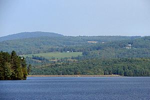
Waterford seen across Moore Reservoir
|
|

Waterford, Vermont
|
|
| Country | United States |
| State | Vermont |
| County | Caledonia |
| Chartered | November 8, 1780, |
| Communities | Lower Waterford West Waterford |
| Area | |
| • Total | 39.7 sq mi (102.9 km2) |
| • Land | 38.3 sq mi (99.2 km2) |
| • Water | 1.4 sq mi (3.7 km2) |
| Elevation | 1,306 ft (398 m) |
| Population
(2020)
|
|
| • Total | 1,268 |
| • Density | 33/sq mi (12.8/km2) |
| Time zone | UTC−5 (Eastern (EST)) |
| • Summer (DST) | UTC−4 (EDT) |
| ZIP Code |
05819
|
| Area code(s) | 802 |
| FIPS code | 50-77125 |
| GNIS feature ID | 1462245 |
Waterford is a small town in Caledonia County, Vermont, United States. In 2020, about 1,268 people lived there. It's a quiet place with a rich history and beautiful natural surroundings.
Contents
Town History
Waterford was officially created on November 8, 1780. It was first called Littleton. However, its name was changed to Waterford in 1797. The town might have been named after Waterford, Ireland. Another idea is that it was named for a "ford" (a shallow place to cross a river) over the Connecticut River nearby.
Exploring Waterford's Geography
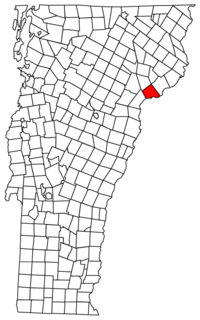
Waterford is located in eastern Caledonia County. It sits right on the Connecticut River, which forms Vermont's eastern border.
Neighboring Towns
Waterford shares its borders with several other towns. To the west is Barnet. To the northwest, you'll find St. Johnsbury. Kirby is to the north, and Concord, Vermont is to the east. Across the Connecticut River to the south is the town of Littleton, New Hampshire.
Land and Water
The town of Waterford covers about 102.9 square kilometers (about 39.7 square miles). Most of this area, about 99.2 square kilometers (38.3 square miles), is land. The rest, about 3.7 square kilometers (1.4 square miles), is water. This means about 3.59% of Waterford is covered by water.
Major Roads and Highways
Two important highways, Interstate 93 and Interstate 91, pass through Waterford. The northern end of I-93 connects with I-91 in the western part of town. This is just south of St. Johnsbury. Exit 1 on I-93 helps people get to the northern part of Waterford. Also, Vermont Route 18 is a two-lane road that runs alongside I-93.
Highest Point
The highest spot in Waterford is Fuller Hill. Its peak is about 2,017 feet (615 meters) high. It is located near the town's eastern border.
Who Lives in Waterford?
| Historical population | |||
|---|---|---|---|
| Census | Pop. | %± | |
| 1790 | 63 | — | |
| 1800 | 565 | 796.8% | |
| 1810 | 1,289 | 128.1% | |
| 1820 | 1,247 | −3.3% | |
| 1830 | 1,358 | 8.9% | |
| 1840 | 1,388 | 2.2% | |
| 1850 | 1,412 | 1.7% | |
| 1860 | 1,171 | −17.1% | |
| 1870 | 879 | −24.9% | |
| 1880 | 815 | −7.3% | |
| 1890 | 734 | −9.9% | |
| 1900 | 705 | −4.0% | |
| 1910 | 629 | −10.8% | |
| 1920 | 574 | −8.7% | |
| 1930 | 712 | 24.0% | |
| 1940 | 498 | −30.1% | |
| 1950 | 468 | −6.0% | |
| 1960 | 460 | −1.7% | |
| 1970 | 586 | 27.4% | |
| 1980 | 882 | 50.5% | |
| 1990 | 1,190 | 34.9% | |
| 2000 | 1,104 | −7.2% | |
| 2010 | 1,280 | 15.9% | |
| 2020 | 1,268 | −0.9% | |
| U.S. Decennial Census | |||
In 2000, there were 1,104 people living in Waterford. These people lived in 424 homes, and 340 of these were families. The population density was about 28.9 people per square mile.
Diversity in Waterford
Most people in Waterford were White (98.55%). A small number were Asian (0.27%), and 1.18% were from two or more races. About 0.27% of the population was Hispanic or Latino.
Households and Families
About 32.1% of homes had children under 18 living there. Most homes (71.7%) were married couples living together. About 5.4% of homes had a female head of household with no husband. Nearly 20% of homes were not families. About 15.8% of homes had only one person. Of these, 6.1% were people aged 65 or older. The average home had 2.60 people, and the average family had 2.88 people.
Age Groups
The median age in Waterford was 42 years old. This means half the people were younger than 42, and half were older.
- 24.6% of the population was under 18.
- 4.3% was between 18 and 24.
- 25.7% was between 25 and 44.
- 31.4% was between 45 and 64.
- 13.9% was 65 or older.
For every 100 females, there were about 104.4 males. For every 100 females aged 18 and over, there were about 100.5 males.
Arts and Culture
The area known as "White Village" in Waterford is a special place. It has homes built in the 1700s. You can also find a church, a library, a post office, and a bed and breakfast there. It's a charming spot to visit!
Economy and Income
In 2000, the average income for a household in Waterford was $50,197. For families, the average income was $52,105. Men earned about $32,100 on average, while women earned about $23,839. The average income per person in the town was $21,762.
Poverty Levels
About 2.3% of families and 4.2% of all people lived below the poverty line. This included 3.3% of those under 18 and 6.3% of those aged 65 or older.
Income Ranking
Waterford has the highest income per person of any town or city in the Northeast Kingdom region of Vermont. It ranks 74th out of 282 census areas in Vermont for income.
Education in Waterford
Waterford Public Schools are part of the Caledonia Central Supervisory Union. This school district provides education for students from pre-kindergarten up to eighth grade.
Famous People from Waterford
Waterford has been home to some notable individuals:
- Amos K. Hadley was a Speaker of the New York State Assembly. This means he was a leader in the government of New York State.
- Jonathan Ross served as the Chief Justice of the Vermont Supreme Court. He was also a United States senator from Vermont. This means he helped make laws for the entire country.
See also
 In Spanish: Waterford (Vermont) para niños


