
Wells-next-the-Sea facts for kids
Quick facts for kids Wells-next-the-Sea |
|
|---|---|
 The quayside |
|

Wells-next-the-Sea
|
|
| Area | 16.31 km2 (6.30 sq mi) |
| Population | 2,165 (2011 Census) |
| • Density | 133/km2 (340/sq mi) |
| OS grid reference | TF 914 430 |
| District | |
| Shire county | |
| Region | |
| Country | England |
| Sovereign state | United Kingdom |
| Post town | WELLS-NEXT-THE-SEA |
| Postcode district | NR23 |
| Dialling code | 01328 |
| Police | Norfolk |
| Fire | Norfolk |
| Ambulance | East of England |
| EU Parliament | East of England |
| UK Parliament |
|
Wells-next-the-Sea is a charming port town located on the north coast of Norfolk, England. It's a popular spot for visitors and locals alike.
The town and its surrounding area cover about 16.31 square kilometers. In 2001, about 2,451 people lived here, and by 2011, the population was 2,165.
Wells is about 15 miles east of Hunstanton and 20 miles west of Cromer. It's also 10 miles north of Fakenham. The big city of Norwich is about 32 miles to the south-east. Nearby villages include Blakeney, Burnham Market, Burnham Thorpe, Holkham, and Walsingham.
Contents
What's in a Name?
The name Wells comes from an old word, Wella, meaning "spring". This is because the area used to have many natural springs and wells that bubbled up through the chalk ground.
In the early 1800s, people started calling it Wells-next-the-Sea. This helped tell it apart from other places with the same name. When the Wells and Fakenham Railway opened in 1857, the train station was called "Wells-on-Sea". But in 1956, the local council decided to officially go back to the name Wells-next-the-Sea, and it has been known by that name ever since.
A Look Back in Time
Wells has been an important seaport for a very long time, even before the 1300s! Back then, it sent grain to London and coal miners in the north-east. In return, Wells received coal. Before the 1800s, it was much easier to move heavy goods by sea than by land.
By the 1500s, Wells was a major port in the area. It had 19 ships that were bigger than 16 tons in 1580. The town also became famous for making malt, which is used to make beer. At its busiest, Wells had up to twelve maltings (places where malt is made). In 1750, Wells sent more malt to other countries, especially Holland, than almost any other port in England.
Wells was also a busy fishing port. In 1337, it had thirteen fishing boats. Fishermen from Wells caught herring and cod from Iceland between the 1400s and 1600s.
To keep the harbour working well, rules were made in 1663. Later, in 1769, Harbour Commissioners were put in charge of ships coming and going. The main quay was rebuilt in 1845 to make the town better. At the same time, people worked to make Wells a nice place for both residents and the growing number of tourists.
Wells used to build ships until the late 1800s. However, it never started building modern ships made of steel or with motors. When the railway arrived in 1857, the harbour trade slowed down. But it picked up again after the Second World War, importing things like fertilizer and animal feed.
The harbour in Wells depends on the tides to keep it clear of silt (mud and sand). This is because no river flows through the town. Silt has been a problem for hundreds of years. Even famous engineers tried to solve it, but no solution lasted forever.
In the 1800s, making malt became a big business. Eventually, a company called F. & G. Smith bought all the maltings in Wells. They became one of the biggest malt producers in the country. But after the First World War, demand for malt fell. The Wells maltings closed in 1929. Other farming businesses also closed or were bought out over the years.
The harbour became busy again from the 1960s to the 1990s. Small ships brought in fertilizer and animal feed, especially soya beans. But by 1992, new rules and bigger ships made the port too expensive to use.
More recently, Wells has supported the building of the Sheringham Shoal Offshore Wind Farm since 2009. However, these operations moved away from Wells in 2021.
Tourism started small a century ago but has now become a huge part of Wells. Many people visit the Pinewoods Caravan site, which has grown a lot. Because of tourism, many houses in Wells are now second homes, meaning people own them but don't live there all the time. In 2019, over 34% of homes were second homes.
Exploring Wells
The North Sea is now about a mile from the town. This is because the harbour has filled with silt over time. In 1859, the Holkham Estate built a long sea-wall, reclaiming about 800 hectares of saltmarsh. This also made the silting worse.
Wells has always been a busy seaport. Now, it's also a popular seaside resort with a lovely beach. You can walk to the beach or take a fun narrow-gauge railway that runs along the sea wall. The beach is known for its long, flat sands, interesting sand dunes, and unique beach huts. There's also a salty pool called Abraham's Bosom where people enjoy boating and canoeing. Behind the beach are thick pine woods, which are part of the Holkham National Nature Reserve. These woods have different types of pine trees growing in the sand.
More pine woods are found to the east of the beach, across the shipping channel, in an area called the East Hills. You can walk there at low tide, but be very careful! The tidal sands in this area are dangerous because the tide comes in very fast. It's best not to cross the channel without knowing the local area well.
The town itself stretches almost a mile inland. Most shops are now on Staithe Street. But in the past, there were also many businesses along High Street, which goes south towards St Nicholas's Church. The church was damaged by lightning in 1879. Its outside looks old, but the inside is quite plain. John Fryer, who was Captain Bligh's sailing master on HMS Bounty, was born in Wells and is buried in the churchyard.
A famous building on the quay is the old granary, built between 1902 and 1904. It has a large gantry (a structure for lifting things) hanging over the water. It stopped being a granary in 1990 and has now been turned into flats. Wells used to have many pubs for its size because of its strong maritime history, but many have now closed.
The northern part of the town used to have narrow rows of cottages called "yards." Many of these were destroyed in the terrible 1953 flood. The 1953 flood also damaged the pine forest near Abraham's Bosom. Today, there's a big moving flood gate near the harbour car park, and many houses have their own flood defenses.
Another special part of town is The Buttlands. This is a large green area surrounded by lime trees. Beautiful Georgian houses, the Crown Hotel, the Globe Inn, and the Wells Catholic Church all overlook The Buttlands. If you walk down the hill from the south-west corner of The Buttlands, you can see Ware Hall. This hall was rebuilt over many years starting in the 1970s by Miss May Savidge, who moved it piece by piece from Ware in Hertfordshire.
How Wells is Governed
Wells-next-the-Sea has three levels of local government:
- The Wells-next-the-Sea Town Council (local level)
- The North Norfolk District Council (district level)
- The Norfolk County Council (county level)
The Town Council has its offices at the Wells Community Hospital on Mill Road.
| Wells-next-the-Sea | |
|---|---|
| Improvement Commissioners District (1844–1894) Urban District (1894–1974) |
|
| Population | |
| • 1891 | 2,555 |
| • 1971 | 2,245 |
| History | |
| • Created | 1844 (Improvement Commissioners District) 31 December 1894 (Urban District) |
| • Abolished | 31 March 1974 |
| • Succeeded by | North Norfolk |
| • HQ | Wells-next-the-Sea |
| Contained within | |
| • County Council | Norfolk |
Wells-next-the-Sea was an old parish within the hundred of North Greenhoe. For a long time, it was governed by its vestry, like most rural parishes. In 1844, a special law created improvement commissioners to manage the town's local government.
In 1894, these commissioners were replaced by an elected urban district council. This council had offices in the town. In 1954, they bought a former cinema to use as their offices and meeting place.
The urban district council was closed down in 1974. The area then became part of North Norfolk. A new parish council, called Wells-next-the-Sea Town Council, was set up to take its place. The old council offices were later turned into homes in the 1990s.
Getting Around Wells
Trains

When the railway arrived in 1857, it actually caused the town's population to drop, as seen in the 1861 census. Wells used to have two train lines connecting it to the main British Rail network. The line going west towards King's Lynn was never fixed after being damaged in the North Sea flood of 1953. The line to Norwich was closed in the 1960s as part of the "Beeching Axe" cuts.
Today, the Wells and Walsingham Light Railway uses part of the old track. This is a special 10¼ inch-gauge railway, which is the longest of its kind in the world! It has its own separate Wells railway station.

Besides the passenger train lines, there was also a tramway from the station to the quayside at Wells Harbour. You can still see its rails under the road surface along East Quay today. Horses pulled the wagons along the quay because locomotives weren't allowed.
The Wells Harbour Railway was another small 10¼ inch-gauge railway. It took passengers from the harbour towards the beach and caravan site. It ran from 1976 to 2021, when its tracks were removed.
Buses
Wells used to be on the popular Coasthopper bus route, which ran between King's Lynn and Cromer. In 2018, the service changed. Now, the route from King's Lynn to Wells is called the Coastliner 36 and goes inland to Fakenham. The route from Wells to Cromer is run by a different company, Sanders Coaches.
Lifeboat Heroes
A new Lifeboat station opened in 2022. It houses the new Shannon-class lifeboat called the Duke of Edinburgh. This new boat replaced the Doris Mann of Ampthill, which had served the town since 1990. The old lifeboat station was taken down after the new one opened. A new, longer launch slipway was also built. This is needed to get the lifeboat back after a rescue. If the tide is out during a rescue, the boat has to be taken over a mile of sand to be launched in Holkham Bay.
There's also a smaller, fast inflatable boat used for rescues closer to the coast. This boat has helped many people who get cut off by the tide or carried out to sea while swimming or using paddleboards.
The even older lifeboat house, built in the 1860s, is now used as the harbour office. It's at the western end of the quay.
In 1880, there was a terrible accident called the Wells lifeboat disaster. Eleven out of thirteen crew members drowned. This left ten wives and 27 children without their fathers. There's a memorial to these brave crew members next to the old lifeboat house.
Learning in Wells
Wells has a history of schools. In 1678, Christopher Ringer left money in his will to educate thirty boys and thirty girls in the town. Several private schools were set up in the 1800s, but none of them are still open today.
A National School was created after the town's workhouse closed. A British School was also set up in 1938, which later became a Board School in 1875. A secondary school was built in 1929, and the original school became the primary school.
The primary school closed in 1964 when the Alderman Peel secondary modern school was built in a different part of town. The old school buildings were used for a while as a field studies center. Now, they have been turned into social housing by a local housing group. Wells schools are now part of the Wensum Trust, which manages 24 schools in Norfolk.
Media and News
If you're in Wells, you can watch TV signals from the Belmont TV transmitter, which broadcasts BBC Yorkshire and Lincolnshire and ITV Yorkshire programs. There's also a local relay transmitter that broadcasts BBC East and ITV Anglia from the Tacolneston TV transmitter.
For local radio, you can listen to BBC Radio Norfolk, Heart East, Amber Radio, Greatest Hits Radio East, and Poppyland Community Radio.
Local newspapers include the Fakenham & Wells Times, North Norfolk News, and Eastern Daily Press.
The Beach and its Siren
The beach at Wells-next-the-Sea is part of the Holkham National Nature Reserve. The tides here are always changing. To keep everyone safe, an old war siren is used to warn people about incoming high tides. The siren sounds about 5–10 minutes before the tide is expected to cover the beach. This gives everyone enough time to leave the area safely.
Storms and Flooding
Wells has experienced flooding for centuries, going back to the 1200s. In the 1900s, the famous North Sea flood of 1953 caused a lot of damage. Another dangerous storm surge happened in 1978, but the town was better prepared that time.
On December 5, 2013, a storm surge caused serious damage to properties on the Quay and to the east. However, the west end of town was protected by a tidal barrier built in 1982. The Prime Minister, David Cameron, visited Wells on December 9, 2013, to see the damage from the flooding.
Gallery
-
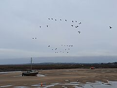
Beached boat at Wells-next-the-Sea
-
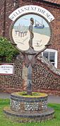
Signpost in Wells-next-the-Sea
-
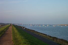
The Wells Harbour mouth from the sea wall; the lifeboat house can be seen in the distance
-
Inland Wells, with view to Wells Harbour
-
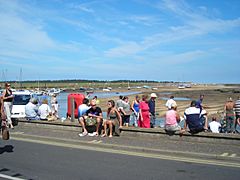
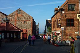
Looking out to the quay on a sunny August 2006 day
-
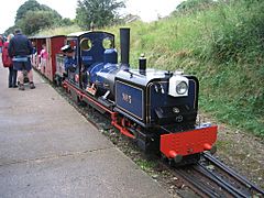
The train from Wells arrives at Walsingham station
-
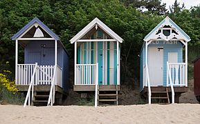
Huts on the beach
-
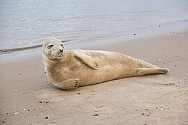
Grey seal on the beach
.jpg)


See also
 In Spanish: Wells-next-the-Sea para niños
