Winslow, Arizona facts for kids
Quick facts for kids
Winslow, Arizona
|
||
|---|---|---|
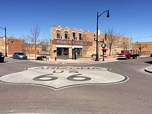
Standin' on the Corner Park in downtown Winslow
|
||
|
||
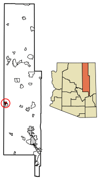
Location of Winslow in Navajo County, Arizona.
|
||
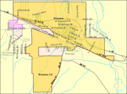
U.S. Census Map
|
||
| Country | United States | |
| State | Arizona | |
| County | Navajo | |
| Incorporated | 1900 | |
| Area | ||
| • Total | 13.04 sq mi (33.78 km2) | |
| • Land | 12.99 sq mi (33.64 km2) | |
| • Water | 0.05 sq mi (0.14 km2) | |
| Elevation | 4,866 ft (1,483 m) | |
| Population
(2020)
|
||
| • Total | 9,005 | |
| • Density | 693/sq mi (268/km2) | |
| Time zone | UTC−7 (MST) | |
| ZIP code |
86047
|
|
| Area code(s) | 928 | |
| FIPS code | 04-83930 | |
| GNIS ID(s) | 2412286 | |
Winslow is a city located in Navajo County, Arizona, in the United States. In 2020, about 9,005 people lived there. It is about 57 miles (92 km) southeast of Flagstaff. Winslow is also about 240 miles (386 km) west of Albuquerque, New Mexico. It is 329 miles (530 km) southeast of Las Vegas. The city's name in the Navajo language is Navajo: Béésh Sinil.
Contents
History of Winslow
Winslow got its name from an important person. It was named after either Edward F. Winslow or Tom Winslow. Edward F. Winslow was the president of a railway company. Tom Winslow was a prospector who explored the area.
The Famous La Posada Hotel
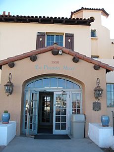
The last Harvey House hotel was built in Winslow. It was designed by Mary Colter and opened in 1930. This hotel closed in 1957. The Santa Fe Railway then used it for offices. In 1994, the railroad planned to tear it down. However, Allan Affeldt bought and saved the building. Today, it is known as the La Posada Hotel and has been beautifully restored.
Winslow and Route 66
U.S. Route 66 used to go right through Winslow. This famous road was a main route across the country. In 1977, work began on Interstate 40. I-40 was built to go around Winslow. It replaced all of U.S. Route 66 in Arizona.
Winslow in Music
Winslow became famous in 1972 because of a song. The band Eagles and Jackson Browne wrote "Take It Easy". The song has a line that says, "standin' on a corner in Winslow, Arizona." This made the city well-known around the world.
Geography and Climate
Winslow is located in a dry, temperate area. The city has an area of about 12.3 square miles (31.9 km2). All of this area is land. Winslow is about 57 miles (92 km) southeast of Flagstaff. It is also about 320 miles (515 km) west of Albuquerque, New Mexico. Las Vegas is about 329 miles (530 km) to the southeast.
Weather in Winslow
Winslow has a dry climate with warm days and cool nights. Winters are cool and dry. Summers are hot and bring most of the rain. On average, Winslow gets about 7 inches (178 mm) of rain each year. It also gets about 8.1 inches (21 cm) of snow per year.
| Climate data for Winslow Municipal Airport, Arizona (1991–2020 normals, extremes 1915–present) | |||||||||||||
|---|---|---|---|---|---|---|---|---|---|---|---|---|---|
| Month | Jan | Feb | Mar | Apr | May | Jun | Jul | Aug | Sep | Oct | Nov | Dec | Year |
| Record high °F (°C) | 75 (24) |
82 (28) |
85 (29) |
92 (33) |
101 (38) |
108 (42) |
110 (43) |
104 (40) |
103 (39) |
94 (34) |
83 (28) |
74 (23) |
110 (43) |
| Mean maximum °F (°C) | 63.9 (17.7) |
70.3 (21.3) |
77.9 (25.5) |
85.2 (29.6) |
92.9 (33.8) |
101.3 (38.5) |
102.5 (39.2) |
99.0 (37.2) |
94.4 (34.7) |
86.6 (30.3) |
75.0 (23.9) |
65.3 (18.5) |
103.6 (39.8) |
| Mean daily maximum °F (°C) | 49.8 (9.9) |
56.2 (13.4) |
64.5 (18.1) |
71.9 (22.2) |
81.2 (27.3) |
92.3 (33.5) |
94.6 (34.8) |
91.7 (33.2) |
85.6 (29.8) |
73.8 (23.2) |
60.3 (15.7) |
48.7 (9.3) |
72.6 (22.6) |
| Daily mean °F (°C) | 35.9 (2.2) |
41.0 (5.0) |
48.2 (9.0) |
54.9 (12.7) |
63.7 (17.6) |
73.8 (23.2) |
79.1 (26.2) |
77.1 (25.1) |
69.7 (20.9) |
57.1 (13.9) |
44.6 (7.0) |
35.2 (1.8) |
56.7 (13.7) |
| Mean daily minimum °F (°C) | 22.0 (−5.6) |
25.9 (−3.4) |
31.8 (−0.1) |
37.9 (3.3) |
46.2 (7.9) |
55.2 (12.9) |
63.7 (17.6) |
62.5 (16.9) |
53.8 (12.1) |
40.4 (4.7) |
28.9 (−1.7) |
21.7 (−5.7) |
40.8 (4.9) |
| Mean minimum °F (°C) | 7.5 (−13.6) |
11.4 (−11.4) |
17.5 (−8.1) |
24.1 (−4.4) |
32.7 (0.4) |
42.7 (5.9) |
53.9 (12.2) |
54.1 (12.3) |
39.8 (4.3) |
24.6 (−4.1) |
12.7 (−10.7) |
7.1 (−13.8) |
4.3 (−15.4) |
| Record low °F (°C) | −18 (−28) |
−9 (−23) |
−2 (−19) |
14 (−10) |
23 (−5) |
29 (−2) |
42 (6) |
41 (5) |
29 (−2) |
7 (−14) |
−9 (−23) |
−12 (−24) |
−18 (−28) |
| Average precipitation inches (mm) | 0.51 (13) |
0.42 (11) |
0.49 (12) |
0.25 (6.4) |
0.30 (7.6) |
0.14 (3.6) |
0.89 (23) |
1.16 (29) |
0.87 (22) |
0.51 (13) |
0.48 (12) |
0.50 (13) |
6.52 (166) |
| Average snowfall inches (cm) | 1.9 (4.8) |
1.4 (3.6) |
1.4 (3.6) |
0.1 (0.25) |
0.0 (0.0) |
0.0 (0.0) |
0.0 (0.0) |
0.0 (0.0) |
0.0 (0.0) |
0.0 (0.0) |
0.7 (1.8) |
2.6 (6.6) |
8.1 (21) |
| Average precipitation days (≥ 0.01 inch) | 4.3 | 4.2 | 4.0 | 2.7 | 2.7 | 1.5 | 6.3 | 8.1 | 4.8 | 3.4 | 3.2 | 4.3 | 49.5 |
| Average snowy days (≥ 0.1 inch) | 1.9 | 1.2 | 1.1 | 0.2 | 0.0 | 0.0 | 0.0 | 0.0 | 0.0 | 0.0 | 0.7 | 1.9 | 7.0 |
| Source 1: NOAA (snow/snow days 1981–2010) | |||||||||||||
| Source 2: National Weather Service | |||||||||||||
People of Winslow
| Historical population | |||
|---|---|---|---|
| Census | Pop. | %± | |
| 1890 | 363 | — | |
| 1900 | 1,305 | 259.5% | |
| 1910 | 2,381 | 82.5% | |
| 1920 | 3,730 | 56.7% | |
| 1930 | 3,917 | 5.0% | |
| 1940 | 4,577 | 16.8% | |
| 1950 | 6,518 | 42.4% | |
| 1960 | 8,862 | 36.0% | |
| 1970 | 8,066 | −9.0% | |
| 1980 | 7,921 | −1.8% | |
| 1990 | 8,190 | 3.4% | |
| 2000 | 9,520 | 16.2% | |
| 2010 | 9,655 | 1.4% | |
| 2020 | 9,005 | −6.7% | |
| U.S. Decennial Census | |||
In 2000, there were 9,520 people living in Winslow. There were 2,754 households and 1,991 families. The city had about 773 people per square mile (298 per km2).
Many different groups of people live in Winslow. About 40.8% of the people were White. About 28.8% were Hispanic or Latino. Native Americans made up 23.5% of the population. Other groups included Black or African American (5.2%) and Asian (1.0%). About 4.2% of people were from two or more races.
In Winslow, 40.3% of households had children under 18. About 50.2% were married couples. The average household had 2.86 people. The average family had 3.40 people.
The population of Winslow is spread out by age. About 29.8% were under 18 years old. About 10.0% were 65 years or older. The average age in the city was 31 years.
Education in Winslow
The Winslow Unified School District serves the city. This district manages the public schools in Winslow.
Winslow has three public elementary schools. These are Bonnie Brennan Elementary, Jefferson Elementary, and Washington Elementary. For older students, there is Winslow Junior High School. Winslow High School serves the city's high school students. Winslow also has a college campus. It is the Little Colorado Campus of Northland Pioneer College.
There is also a tribal elementary school near Winslow. The Little Springs Community School is linked with the Bureau of Indian Education. It has a Winslow mailing address. However, it is actually about 6 miles (10 km) southeast of Birdsprings.
Transportation in Winslow
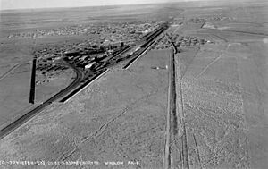
Winslow has an airport called Winslow-Lindbergh Regional Airport. It was first built by Transcontinental Air Transport. Charles Lindbergh helped design this airport. He even stayed in Winslow while it was being built. At that time, it was the only commercial airport between Albuquerque and Los Angeles. Today, there are no commercial flights from this airport.
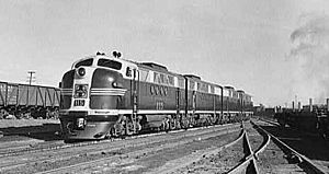
Winslow also has a train station. The Amtrak Southwest Chief train stops here twice a day. One train goes east and one goes west. The city is on the BNSF railroad's main route. This route connects Los Angeles and Chicago, Illinois. Winslow is also a place where train crews change shifts.
You can also take a bus from Winslow. Hopi Senom Transit provides bus service. This service connects Winslow to the Hopi Reservation.
Interstate 40 runs just north of Winslow. The old U.S. Route 66 is now a business route through the city.
Fun Places to Visit in Winslow
The historic La Posada hotel has been restored. It is a beautiful place to visit.
Meteor Crater
Near Winslow is the famous Meteor Crater. It is sometimes called the Barringer Crater. This huge hole in the ground was made by a meteor hitting Earth.
Standin' on the Corner Park
Standin' on the Corner Park is a popular spot downtown. It has murals that show scenes from the song "Take It Easy." Winslow also has an annual festival. It is called the Standin' On The Corner street festival. This event usually happens in the last week of September.
Painted Desert and Petrified Forest
The Painted Desert is about 60 miles (97 km) east of Winslow. The Petrified Forest is also in that area. These places have amazing colorful landscapes and ancient fossilized trees. The Little Painted Desert is closer, about 18 miles (29 km) north of Winslow.
9-11 Remembrance Gardens
The 9-11 Remembrance Gardens honors those who lost their lives on September 11 attacks. This memorial was built using two beams. These beams came from the World Trade Center towers in New York City. Many people helped build this memorial. It was finished and celebrated on September 11, 2002.
Historical Events in Winslow
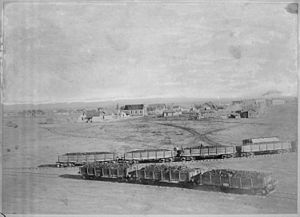
In the past, Winslow was a very important stop for steam trains. The Atchison, Topeka and Santa Fe Railway trains would stop there to get water and fuel. Passengers could get off and eat a meal. In the 1920s, many famous people traveled to Hollywood. When they stopped in Winslow, there was often a parade. The local newspaper would write about these special events.
Winslow also had a large train repair center. This center was for the Santa Fe railroad. Later, a new center in California took over. This caused Winslow to become less important for train maintenance. Many railroad workers moved away.
In 1949, the Shah of Iran visited America. He wanted to see the Grand Canyon. His plane landed at the Winslow airport. From there, he traveled by car to the canyon.
Media
Radio Stations
- KINO – 1230AM
Notable People
Many interesting people have connections to Winslow:
- Erika Alexander, an actress.
- Brad Carson, a former U.S. Under Secretary of the Army and congressman.
- Bill Engvall, a comedian who lived in Winslow in the early 1970s.
- Deb Haaland, the first Native American woman elected to Congress. She is also the 54th United States Secretary of the Interior.
- Michael Daly Hawkins, a U.S. Attorney and U.S. Circuit Judge.
- Nick Hysong, a gold medalist in pole vault at the 2000 Summer Olympic Games.
- Richard Kleindienst, who was the United States Attorney General under Richard Nixon.
- Vernon Lattin (born 1938), a president of Brooklyn College.
- Paul M. Lally, a producer, director, and writer for "Mister Rogers' Neighborhood." He lived in Winslow in the late 1950s.
- Tina Mion, an artist.
- Tommy Singer, a Navajo silversmith known for his chip-inlay jewelry.
- Jay R. Vargas, a Medal of Honor recipient from the Vietnam War.
Images for kids
See also
 In Spanish: Winslow (Arizona) para niños


