Yamsay Mountain facts for kids
Quick facts for kids Yamsay Mountain |
|
|---|---|

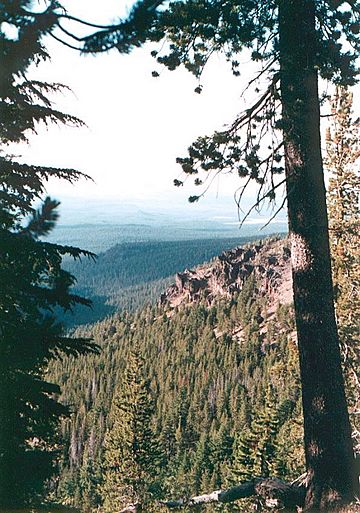
View from Yamsay Mountain
|
|
| Highest point | |
| Elevation | 8,200 ft (2,499 m) NAVD 88 |
| Prominence | 3,176 ft (968 m) |
| Geography | |
| Location | Klamath County, Oregon, U.S. |
| Parent range | Cascade Range |
| Topo map | USGS Yamsay Mountain |
| Geology | |
| Mountain type | Shield volcano |
| Climbing | |
| Easiest route | Trail (formerly a road) |
Yamsay Mountain is a huge shield volcano in south-central Oregon. It's part of the Cascade Range. This mountain is about 35 miles (56 km) east of Crater Lake. It sits on the border between Klamath County and Lake County.
Yamsay Mountain is part of the Cascade Volcanic Arc. This arc is a chain of volcanoes. It's located a bit behind the main Cascade mountains. Other famous volcanoes in this area include Newberry Volcano and Medicine Lake Volcano. Yamsay is the second tallest volcano in this eastern arc. It stands almost 300 feet (91 m) higher than Newberry and Medicine Lake.
This mountain is very important in the stories of the Klamath people. Today, you can enjoy activities like hiking and horseback riding there. For a long time, Native American tribes and settlers lived around the mountain. A fire lookout tower once stood on its top until the 1970s. You can still see parts of its foundation today.
Contents
Exploring Yamsay Mountain
How Yamsay Mountain Formed

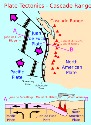
Like other volcanoes in the Cascade Range, Yamsay Mountain was created by plate tectonics. This happens when one of Earth's huge plates slides under another. Here, the oceanic Juan de Fuca Plate is sliding under the North American Plate. This movement still happens today, about 1.6 inches (4 cm) each year.
The Cascades are a major chain of volcanoes on the West Coast of North America. They have been active for about 36 million years. The rocks in the Cascades are even older, from 55 to 42 million years ago. Scientists divide these volcanoes into two groups. The "High Cascades" are the younger ones. The "Western Cascades" are the older volcanoes.
Yamsay Mountain is a shield volcano. This means it has a wide, gently sloping shape. It formed from many runny lava flows. Yamsay, along with other volcanoes like Newberry, are a bit east of the main Cascade Range. Their eruptions are a bit different from other Cascade volcanoes.
Types of Rocks and Eruptions
Volcanoes in the Cascades have erupted different types of rock. From 7 to 2 million years ago, they mostly produced basalt and basaltic andesite. These are dark, dense rocks. On the eastern side of the High Cascades, volcanoes also erupted dacite, andesite, and rhyolite. These rocks can be lighter in color.
These materials created different kinds of eruptions. Some formed lava flows, which are rivers of molten rock. Others created domes, which are rounded mounds of lava. Some eruptions also made pyroclastic flows. These are fast-moving clouds of hot gas and ash. More recently, volcanoes like the Three Sisters and Crater Lake have erupted basalt, andesite, and rhyolite.
Yamsay Mountain's Past
The Name and Native American History
The name Yamsay comes from the Klamath word Yamsi. This means "north wind." The Klamath believed this mountain was the home of Kmukamtch. He was the most important being in their stories.
Historically, the area around Yamsay Mountain was home to several Native American tribes. These included the Klamath, Modoc, and Yahooskin Bands. The Yahooskins lived east of Yamsay Mountain. Their group once lived on a huge area of land in Oregon and California.
Settlers and Development
Traders from the Hudson's Bay Company came to the area around 1825. They worked as trappers. Later, new routes opened up in 1846. Fort Klamath was built in 1863.
The city of Klamath Falls grew quickly in the 1920s. It is southwest of Yamsay. The Southern Pacific Railroad helped this growth. It was finished in 1909. This railroad opened the area for logging and timber businesses. These became very important for the local economy.
The Fire Lookout Tower
In 1929, the United States Forest Service built an 80-foot (24 m) steel fire lookout tower on Yamsay's summit. This tower helped spot forest fires. It was removed after the 1970s. Today, only parts of its foundation remain. A dirt road was built to reach the lookout. After the tower was gone, this road was no longer used. The top 3.5 miles (5.6 km) of the old road are now a hiking trail.
Nature Around Yamsay
Climate and Trees
The climate changes a lot from the west to the east side of the Cascade Range. The west side has thick forests. You can find Douglas firs, western hemlock, and Pacific silver firs there. East of the Cascades, where Yamsay Mountain is, the climate is much drier. It can even be like a desert.
There is less rain on the east side. The plants are also more spread out. You will see lodgepole pine, white fir, ponderosa pine, and juniper trees. Farther south, you might find chaparral plants. These include beargrass and bitterbrush.
Animals of the Cascades
Many different animals live in the Cascade Range. Some are endangered species, like Larch Mountain Salamanders and spotted owls. You can also find many amphibians, such as salamanders and frogs. Birds are common too.
Large mammals in the area include elk, mountain lions, deer, and black bears. The eastern Cascades also have unique fish. These include the Lost River sucker and short sucker. Both of these fish are endemic, meaning they are found only in this area.
Fun Things to Do
The Fremont National Recreation Trail goes through the Yamsay Mountain area. This trail offers amazing views of other Oregon Cascade landmarks. You can see Mount Bachelor, Mount Shasta, Three Sisters, and Mount Thielson.
You can go hiking and horseback riding up Yamsay Mountain. The recreation area starts at an elevation between 6,500 feet (1,981 m) and 8,196 feet (2,498 m). It's a great place to explore nature and enjoy the outdoors.
 | Sharif Bey |
 | Hale Woodruff |
 | Richmond Barthé |
 | Purvis Young |

