
Allier facts for kids
Quick facts for kids
Allier
|
|||
|---|---|---|---|

Prefecture building of the Allier department, in Moulins
|
|||
|
|||

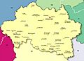
Location of Allier in France
|
|||
| Country | France | ||
| Region | Auvergne-Rhône-Alpes | ||
| Département | 4 March 1790 | ||
| Prefecture | Moulins | ||
| Subprefectures | Montluçon, Vichy | ||
| Area | |||
| • Total | 7,340.1 km2 (2,834.0 sq mi) | ||
| Population
(2014)
|
|||
| • Total | 343,062 | ||
| • Density | 46.7381/km2 (121.0510/sq mi) | ||
| Time zone | UTC+1 (CET) | ||
| • Summer (DST) | UTC+2 (CEST) | ||
| ISO 3166 code | FR-03 | ||
| Arrondissements | 3 | ||
| Cantons | 19 | ||
| Communes | 317 | ||
| Website | http://www.allier.fr | ||

.svg)
Allier is a department in the center of France. It is like a large county or region. It is part of the Auvergne-Rhône-Alpes region. The department is named after the river Allier, which is a smaller river that flows into the Loire. The main city and capital of Allier is Moulins.
Contents
History of Allier
Allier was one of the first 83 departments created during the French Revolution on March 4, 1790. Its capital was Moulins from the start. It was formed mostly from an old area called Bourbonnais. Only a small part of Bourbonnais, Saint-Amand-Montrond, did not become part of Allier.
At first, Allier was divided into seven smaller areas called districts. These were Cérilly, Moulins, Le Donjon, Cusset, Gannat, Montmarault, and Montluçon.
In 1800, these districts changed into four larger areas called arrondissements. These new areas were Moulins, Gannat, Lapalisse, and Montluçon.
Later, in 1926, the Gannat arrondissement was removed. In 1941, Vichy became the capital of an arrondissement instead of Lapalisse.
During World War II in 1940, the city of Vichy became the capital of a special government in France.
Geography of Allier
Allier is located in the Auvergne-Rhône-Alpes region of France. It covers an area of about 7,340 square kilometers (2,834 square miles).
The department is about 130 kilometers (81 miles) long from east to west. It is about 90 kilometers (56 miles) wide from north to south.
Allier shares its borders with six other departments:
- In the north: Nièvre
- In the east: Saône-et-Loire
- In the southeast: Loire
- In the south: Puy-de-Dôme
- In the west: Creuse
- In the northwest: Cher
Geographical Zones
Allier has four main types of landscapes:
- The Bourbonnais Bocage covers about one-third of the department. This area has many small fields, woods, and hedges. It is found in the western and central parts.
- The Bourbonnais Sologne is in the eastern part of Allier. It is located between the Allier River valley and the borders of the Nièvre and Saône-et-Loire departments.
- The Bourbonnais Mountains are in the southeast. Here, the departments of Allier, Puy-de-Dome, and Loire meet. The highest point in Allier is here, called Puy de Montoncel. It is 1,287 meters (4,222 feet) high.
- The Bourbonnais Limagne is also known as Val d'Allier (Valley of the Allier). This area is found on both sides of the Allier River, between Vichy and Saint-Pourçain-sur-Sioule.
Rivers in Allier
The main rivers flowing through Allier are:
- The Cher River in the western part.
- The Allier River and its smaller river, the Sioule, in the center.
- The Loire River and its smaller river, the Besbre, in the east.
Climate in Allier
The climate in Allier is an "Oceanic climate," which means it's like a mild, temperate climate. It has influences from the ocean.
Allier usually gets the most rain in June and October. The driest months are January and February. The average rainfall varies across the department. For example, Montluçon gets about 694 mm (27 inches) of rain each year. Moulins gets about 763 mm (30 inches), and Vichy gets about 778 mm (31 inches).
| Climate data for Vichy | |||||||||||||
|---|---|---|---|---|---|---|---|---|---|---|---|---|---|
| Month | Jan | Feb | Mar | Apr | May | Jun | Jul | Aug | Sep | Oct | Nov | Dec | Year |
| Mean daily maximum °C (°F) | 6.7 (44.1) |
8.7 (47.7) |
11.7 (53.1) |
14.8 (58.6) |
18.7 (65.7) |
22.4 (72.3) |
25.5 (77.9) |
24.7 (76.5) |
22.2 (72.0) |
17.1 (62.8) |
10.8 (51.4) |
7.1 (44.8) |
15.9 (60.6) |
| Daily mean °C (°F) | 2.9 (37.2) |
4.3 (39.7) |
6.4 (43.5) |
9.1 (48.4) |
12.8 (55.0) |
16.3 (61.3) |
18.8 (65.8) |
18.3 (64.9) |
15.8 (60.4) |
17.1 (62.8) |
10.8 (51.4) |
7.1 (44.8) |
15.9 (60.6) |
| Mean daily minimum °C (°F) | −0.9 (30.4) |
−0.2 (31.6) |
1.1 (34.0) |
3.4 (38.1) |
7.06 (44.71) |
10.2 (50.4) |
12.1 (53.8) |
11.8 (53.2) |
9.4 (48.9) |
6.4 (43.5) |
2.3 (36.1) |
−0.5 (31.1) |
5.2 (41.4) |
| Average precipitation mm (inches) | 52.1 (2.05) |
48.2 (1.90) |
51.0 (2.01) |
62.9 (2.48) |
107.6 (4.24) |
79.4 (3.13) |
60.6 (2.39) |
75.4 (2.97) |
77.0 (3.03) |
64.7 (2.55) |
56.9 (2.24) |
54.4 (2.14) |
790.2 (31.11) |
| Mean monthly sunshine hours | 66.1 | 88.1 | 136.6 | 170.9 | 197.1 | 232.6 | 270.7 | 237.8 | 197.9 | 135.9 | 82.3 | 64.2 | 1,880.2 |
| Source: Metereological data for Vichy-Charmeil, from 1961 to 1990 Dec 2014 | |||||||||||||
Administration of Allier
Allier is managed by the Departmental Council of Allier. This council is based in Moulins. The department is part of the Auvergne-Rhône-Alpes region.
Administrative Divisions
Allier is divided into smaller areas to help with its administration. There are:
- 3 arrondissements (which are like large districts)
- 19 cantons (smaller administrative areas)
- 317 communes (which are like towns or municipalities)
Here are the arrondissements of Allier:
| INSEE code |
Arrondissement | Capital | Population (2014) |
Area (km²) |
Density (Inh./km²) |
Communes |
|---|---|---|---|---|---|---|
| 031 | Montluçon | Montluçon | 114,756 | 2,327.9 | 49.3 | 89 |
| 032 | Moulins | Moulins | 106,039 | 2,996.2 | 35.4 | 109 |
| 033 | Vichy | Vichy | 122,267 | 2,016.0 | 60.6 | 119 |
Here is a list of the 19 cantons in Allier. These were updated in March 2015:
- Bellerive-sur-Allier (0301)
- Bourbon-l'Archambault (0302)
- Commentry (0303)
- Cusset (0304)
- Dompierre-sur-Besbre (0305)
- Gannat (0306)
- Huriel (0307)
- Lapalisse (0308)
- Montluçon-1 (0309)
- Montluçon-2 (0310)
- Montluçon-3 (0311)
- Montluçon-4 (0312)
- Moulins-1 (0313)
- Moulins-2 (0314)
- Saint-Pourçain-sur-Sioule (0315)
- Souvigny (0316)
- Vichy-1 (0317)
- Vichy-2 (0318)
- Yzeure (0319)
People of Allier (Demographics)
There isn't one official name for people who live in Allier. Some common names used are Alliérins, Bourbonnais, or simply habitants de l'Allier (which means "inhabitants of Allier").
The most common name used is Bourbonnais.
In 2014, Allier had a population of 343,062 people. This means there were about 46.7 people living in each square kilometer. The arrondissement of Vichy had the most people, with 122,267 inhabitants.
Here's how the population of Allier has changed over time:
Evolution of the population in Allier

Here are the 10 communes (towns or municipalities) in Allier with the most people:
| City | Population (2014) |
Arrondissement |
|---|---|---|
| Montluçon | 37,289 | Montluçon |
| Vichy | 25,279 | Vichy |
| Moulins | 19,762 | Moulins |
| Cusset | 13,386 | Vichy |
| Yzeure | 13,069 | Moulins |
| Domérat | 8,985 | Montluçon |
| Bellerive-sur-Allier | 8,533 | Vichy |
| Commentry | 6,395 | Montluçon |
| Gannat | 5,862 | Vichy |
| Saint-Pourçain-sur-Sioule | 5,039 | Moulins |
Gallery


Related pages
Images for kids
-
Map of Allier
-
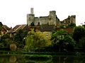
Château de Billy
-
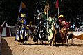
Medieval fair in Montluçon


.JPG)


See also
 In Spanish: Allier para niños
