Andover, Maine facts for kids
Quick facts for kids
Andover, Maine
|
||
|---|---|---|

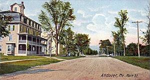
Main Street c. 1906
|
||
|
||
| Country | United States | |
| State | Maine | |
| County | Oxford | |
| Incorporated | 1804 | |
| Area | ||
| • Total | 57.46 sq mi (148.82 km2) | |
| • Land | 57.42 sq mi (148.72 km2) | |
| • Water | 0.04 sq mi (0.10 km2) | |
| Elevation | 669 ft (204 m) | |
| Population
(2020)
|
||
| • Total | 752 | |
| • Density | 14.3/sq mi (5.5/km2) | |
| Time zone | UTC-5 (Eastern (EST)) | |
| • Summer (DST) | UTC-4 (EDT) | |
| ZIP Codes |
04216 (Andover)
04226 (East Andover) |
|
| Area code(s) | 207 | |
| FIPS code | 23-01325 | |
| GNIS feature ID | 0582325 | |
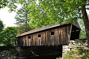
Andover is a small town in Oxford County, Maine, United States. It's surrounded by beautiful mountains. The famous Appalachian Trail even passes through it! In 2020, about 752 people lived here. Andover is known for its historic Lovejoy Covered Bridge and the Andover Earth Station, which played a big role in early satellite communication.
Contents
History of Andover
The land that became Andover was first bought in 1788. A group of people, mostly from Andover, Massachusetts, purchased it. The town was first settled in 1789 by Ezekiel Merrill and his family. They traveled there from Bethel, Maine in canoes. Local Pequawket tribe members helped them.
The first saw-mill was built in 1791 by Colonel Thomas Poor. It provided wood for the Merrill-Poor House, which still stands today. The town officially became a town on June 23, 1804. It was first called East Andover. In 1820, when Maine became its own state, the town was renamed Andover.
Early settlers in Andover mostly worked in farming and logging. As the town grew, factories started making things like doors, windows, and starch. They also made cheese, boots, shoes, and parts for carriages. There was even a place to make leather.
Andover is famous for its beautiful scenery. Its streams are full of trout. After the American Civil War, the town became a popular spot for sportsmen. Many fishermen came to visit the nearby Richardson Lakes. A hotel was built to welcome all the tourists.
In 1960, Andover was chosen for a very important project. The Andover Earth Station was built there and finished in 1962. This station was where the first live TV signal was sent across the Atlantic Ocean by a satellite called Telstar 1.
Geography of Andover
Andover covers about 57.46 square miles. Most of this area is land, with a small amount of water. The Appalachian Trail goes through the town. The Ellis River also flows through Andover. This river is a tributary of the Androscoggin River. It's a great place for fishing and seeing wildlife.
State routes 5 and 120 cross through the town. Andover shares its borders with several other towns. These include Roxbury, Byron, Rumford, and Newry.
Andover's Climate
Andover has a climate with big changes in temperature throughout the year. Summers are warm to hot and can be humid. Winters are cold, sometimes very cold. This type of weather is called a humid continental climate.
| Climate data for Andover 2, Maine 1991–2020 normals: 822ft (251m) | |||||||||||||
|---|---|---|---|---|---|---|---|---|---|---|---|---|---|
| Month | Jan | Feb | Mar | Apr | May | Jun | Jul | Aug | Sep | Oct | Nov | Dec | Year |
| Record high °F (°C) | 54 (12) |
68 (20) |
77 (25) |
89 (32) |
92 (33) |
95 (35) |
97 (36) |
94 (34) |
94 (34) |
83 (28) |
75 (24) |
59 (15) |
97 (36) |
| Mean maximum °F (°C) | 43 (6) |
46 (8) |
54 (12) |
75 (24) |
82 (28) |
87 (31) |
89 (32) |
87 (31) |
83 (28) |
72 (22) |
62 (17) |
48 (9) |
90 (32) |
| Mean daily maximum °F (°C) | 24.4 (−4.2) |
27.7 (−2.4) |
36.5 (2.5) |
49.9 (9.9) |
64.2 (17.9) |
72.3 (22.4) |
77.3 (25.2) |
76.6 (24.8) |
68.5 (20.3) |
54.8 (12.7) |
42.1 (5.6) |
30.3 (−0.9) |
52.0 (11.1) |
| Daily mean °F (°C) | 14.0 (−10.0) |
15.7 (−9.1) |
25.7 (−3.5) |
38.4 (3.6) |
51.5 (10.8) |
60.4 (15.8) |
65.6 (18.7) |
64.0 (17.8) |
56.3 (13.5) |
44.1 (6.7) |
33.1 (0.6) |
21.4 (−5.9) |
40.9 (4.9) |
| Mean daily minimum °F (°C) | 3.5 (−15.8) |
3.6 (−15.8) |
14.8 (−9.6) |
26.9 (−2.8) |
38.8 (3.8) |
48.5 (9.2) |
53.9 (12.2) |
51.3 (10.7) |
44.1 (6.7) |
33.4 (0.8) |
24.0 (−4.4) |
12.5 (−10.8) |
29.6 (−1.3) |
| Mean minimum °F (°C) | −12 (−24) |
−9 (−23) |
−6 (−21) |
17 (−8) |
28 (−2) |
37 (3) |
45 (7) |
42 (6) |
31 (−1) |
23 (−5) |
10 (−12) |
−4 (−20) |
−13 (−25) |
| Record low °F (°C) | −30 (−34) |
−20 (−29) |
−16 (−27) |
8 (−13) |
23 (−5) |
28 (−2) |
39 (4) |
35 (2) |
26 (−3) |
13 (−11) |
0 (−18) |
−17 (−27) |
−30 (−34) |
| Average precipitation inches (mm) | 3.41 (87) |
2.71 (69) |
3.48 (88) |
4.54 (115) |
4.37 (111) |
5.38 (137) |
4.75 (121) |
4.33 (110) |
4.02 (102) |
5.88 (149) |
4.48 (114) |
4.28 (109) |
51.63 (1,312) |
| Average snowfall inches (cm) | 22.50 (57.2) |
26.50 (67.3) |
17.60 (44.7) |
7.00 (17.8) |
0.20 (0.51) |
0.00 (0.00) |
0.00 (0.00) |
0.00 (0.00) |
0.00 (0.00) |
0.60 (1.5) |
8.30 (21.1) |
29.10 (73.9) |
111.8 (284.01) |
| Source 1: NOAA | |||||||||||||
| Source 2: XMACIS (temp records & monthly max/mins) | |||||||||||||
Andover's Population
| Historical population | |||
|---|---|---|---|
| Census | Pop. | %± | |
| 1810 | 271 | — | |
| 1820 | 368 | 35.8% | |
| 1830 | 399 | 8.4% | |
| 1840 | 551 | 38.1% | |
| 1850 | 710 | 28.9% | |
| 1860 | 814 | 14.6% | |
| 1870 | 757 | −7.0% | |
| 1880 | 780 | 3.0% | |
| 1890 | 740 | −5.1% | |
| 1900 | 727 | −1.8% | |
| 1910 | 757 | 4.1% | |
| 1920 | 767 | 1.3% | |
| 1930 | 788 | 2.7% | |
| 1940 | 757 | −3.9% | |
| 1950 | 756 | −0.1% | |
| 1960 | 762 | 0.8% | |
| 1970 | 791 | 3.8% | |
| 1980 | 850 | 7.5% | |
| 1990 | 953 | 12.1% | |
| 2000 | 864 | −9.3% | |
| 2010 | 821 | −5.0% | |
| 2020 | 752 | −8.4% | |
| U.S. Decennial Census | |||
Population in 2010
In 2010, about 821 people lived in Andover. There were 385 households, which are groups of people living together. The average number of people in each household was about 2.13. The average age of people in Andover was 51.1 years old. About 15.6% of the residents were under 18 years old. Also, about 23.9% of the people were 65 years or older.
Places to Visit in Andover
- Andover Earth Station
- Andover Elementary School
- Andover Hook and Ladder Company Building
- Andover Public Library
- East Andover
- Lovejoy Bridge
- Merrill-Poor House
Famous People from Andover
- Charlie Akers, an Olympic biathlete (someone who competes in skiing and shooting)
- Robert W. Duplessie, a politician
- Molly Ockett, an Abenaki healer
- John Orville Newton, a school principal and politician
- Henry Varnum Poor, a financial expert
- John A. Poor, a lawyer and businessman
See also
 In Spanish: Andover (Maine) para niños
 | Jessica Watkins |
 | Robert Henry Lawrence Jr. |
 | Mae Jemison |
 | Sian Proctor |
 | Guion Bluford |


