
Sierra Vista, Arizona facts for kids
Quick facts for kids
Sierra Vista
|
||
|---|---|---|
|
City
|
||

Sierra Vista, Arizona City Hall
|
||
|
||
| Nickname(s):
Hummingbird Capital of the United States
|
||

Location of Sierra Vista in Cochise County, Arizona
|
||

Sierra Vista, Arizona
Location in Arizona

Sierra Vista, Arizona
Location in the United States
|
||
| Country | United States | |
| State | Arizona | |
| County | Cochise | |
| Incorporated | 1956 | |
| Government | ||
| • Type | Council-manager government | |
| • Body | Sierra Vista City Council | |
| Area | ||
| • Total | 152.51 sq mi (395.00 km2) | |
| • Land | 152.25 sq mi (394.33 km2) | |
| • Water | 0.26 sq mi (0.68 km2) | |
| Elevation | 4,633 ft (1,412 m) | |
| Population
(2020)
|
||
| • Total | 45,308 | |
| • Density | 297.59/sq mi (114.90/km2) | |
| Time zone | UTC−7 (MST (no DST)) | |
| ZIP codes |
85613, 85635, 85636, 85650, 85670
|
|
| Area code | 520 | |
| FIPS code | 04-66820 | |

Sierra Vista (which means 'mountain view' in Spanish) is a city in Cochise County, Arizona, United States. In 2020, about 45,308 people lived there, making it the 27th largest city in Arizona. It is part of a bigger area called the Sierra Vista-Douglas Metropolitan Area.
Fort Huachuca, a U.S. Army base, is located in the northwest part of the city. Sierra Vista is near Huachuca City and Whetstone to the north. It is also close to Sierra Vista Southeast to the south.
Sierra Vista is about 75 miles (121 km) southeast of Tucson. It is the main place for shopping, culture, and fun in Cochise County. The city is on the southwestern side of Cochise County. It is about 15 miles (24 km) southwest of Tombstone and 20 miles (32 km) northwest of Bisbee. The border with Mexico is only 15 miles (24 km) away. The closest border crossing to Mexico is Naco, which is about 24 miles (39 km) southeast.
Sierra Vista is home to the University of Arizona, College of Applied Science and Technology. It also has Cochise College and Wick Communications, a company that publishes many newspapers.
Contents
History of Sierra Vista
After the Apache Wars ended, more people started moving to the San Pedro Valley. This was also helped by the protection from Fort Huachuca and the new railroads. Oliver Fry and his sons moved from Texas around 1901. They settled on about 320 acres (1.3 km2) of land near Fort Huachuca.
The first business near Fort Huachuca's east gate was a saloon, opened in 1892. Later, in 1911, Margaret Carmichael bought this property. In 1913, some farmers settled nearby and called their community Buena. Buena had a post office and a school for local children.
In 1917, another settlement called Overton was started. It was named after a company that wanted to build a town near Fort Huachuca. However, the plan did not work out.
By 1918, the Carmichaels changed their store's name to "Garden Canyon." This also became the name of the local post office. The Carmichaels built homes and 18 rock houses on Garden Avenue.
In 1955, people first tried to make the area an official city and give it a new name. This idea was not approved at first. In 1956, the vote failed. However, people who owned land outside Fry's property tried again. They successfully made Sierra Vista an official city on May 26, 1956.
Sierra Vista became a city in 1956. Today, it has over 43,000 people. It is the main business center for Cochise County and northern Sonora, Mexico. In 1971, Sierra Vista included Fort Huachuca, which is one of Arizona's largest employers.
Sierra Vista was also the location of the very first McDonald's drive-thru, which opened in 1975.
Geography and Climate
Sierra Vista is in southwestern Cochise County. It is next to Huachuca City to the northwest.
The city covers about 152.5 square miles (395.1 km2) of land and water. It is located 4,623 feet (1,409 m) above sea level. The Huachuca Mountains are to the southwest of the city. Miller Peak is 9,466 feet (2,885 m) tall, and Carr Peak is 9,236 feet (2,815 m) tall. Both are south of the city. You can reach the city using Arizona State Routes 90 and 92. The San Pedro River flows just east of the city.

Weather in Sierra Vista

Sierra Vista has a cold semi-arid climate. This means it is usually dry. Fall and spring are very dry seasons. Winters are cool or cold, with occasional frosts. Frosts usually stop by mid-to-late April.
Summers start dry but get wetter as the North American Monsoon season begins. This brings heavy rains in July and August. These two months can have almost half of the year's total rainfall. The city has a stable climate with low humidity.
Because of the dry climate and high elevation, winter low temperatures are usually between 20 to 30 °F (−6.7 to −1.1 °C). Sometimes, when warm air comes from the Gulf of California, it can reach 50 °F (10.0 °C). Snow is not common in Sierra Vista. Some years, the city gets several inches of snow, while other years it gets none. However, you can often see snow on Miller Peak and Carr Peak in the Huachuca Mountains for four to five months each year.
- The highest temperature ever recorded was 108 °F (42 °C) in 1989.
- The lowest temperature ever recorded was 3 °F (−16 °C) in 2011.
- The most rain usually falls in August.
| Climate data for Sierra Vista, Arizona | |||||||||||||
|---|---|---|---|---|---|---|---|---|---|---|---|---|---|
| Month | Jan | Feb | Mar | Apr | May | Jun | Jul | Aug | Sep | Oct | Nov | Dec | Year |
| Record high °F (°C) | 81 (27) |
84 (29) |
91 (33) |
97 (36) |
102 (39) |
107 (42) |
108 (42) |
102 (39) |
99 (37) |
96 (36) |
85 (29) |
80 (27) |
108 (42) |
| Mean daily maximum °F (°C) | 61.2 (16.2) |
64.4 (18.0) |
69.7 (20.9) |
76.9 (24.9) |
85.1 (29.5) |
92.9 (33.8) |
91.6 (33.1) |
88.7 (31.5) |
86.8 (30.4) |
78.8 (26.0) |
69.5 (20.8) |
61.6 (16.4) |
77.3 (25.2) |
| Mean daily minimum °F (°C) | 34.2 (1.2) |
37.2 (2.9) |
41.5 (5.3) |
47.1 (8.4) |
54.9 (12.7) |
63.3 (17.4) |
66.3 (19.1) |
64.9 (18.3) |
60.3 (15.7) |
51.0 (10.6) |
40.9 (4.9) |
33.9 (1.1) |
49.6 (9.8) |
| Record low °F (°C) | 12 (−11) |
3 (−16) |
23 (−5) |
28 (−2) |
38 (3) |
46 (8) |
51 (11) |
53 (12) |
45 (7) |
30 (−1) |
19 (−7) |
15 (−9) |
4 (−16) |
| Average rainfall inches (mm) | 0.98 (25) |
0.70 (18) |
0.52 (13) |
0.41 (10) |
0.30 (7.6) |
0.51 (13) |
3.11 (79) |
3.82 (97) |
1.45 (37) |
0.93 (24) |
0.44 (11) |
1.03 (26) |
14.2 (360.6) |
| Average snowfall inches (cm) | 0.3 (0.76) |
0.2 (0.51) |
0.2 (0.51) |
0.0 (0.0) |
0.0 (0.0) |
0.0 (0.0) |
0.0 (0.0) |
0.0 (0.0) |
0.0 (0.0) |
0.0 (0.0) |
0.0 (0.0) |
0.1 (0.25) |
0.8 (2.0) |
| Average rainy days (≥ 0.01 in) | 4 | 4 | 2 | 2 | 1 | 2 | 11 | 12 | 5 | 3 | 2 | 4 | 52 |
| Source: National Weather Service, Tucson | |||||||||||||
Parks and Outdoor Fun

Bird Watching in the Hummingbird Capital
Sierra Vista is known as the "Hummingbird Capital of the United States." People from all over the world come here to watch and photograph hundreds of different bird species. The nearby Ramsey Canyon Preserve and other canyons are great places for this.
Ramsey Canyon in the Huachuca Mountains is a top spot to see hummingbirds in the U.S. The mountains here trap rainfall, creating special areas with lots of different plants and animals. Ramsey Canyon is home to 15 types of hummingbirds. You can see beryline and violet-crowned hummingbirds, which usually breed in Central America.
Other outdoor places to visit include the San Pedro Riparian National Conservation Area and the Coronado National Memorial. Parker Canyon Lake is also nearby for outdoor activities. Sierra Vista's clear night sky makes it a popular place for amateur astronomy. There are many observatories, including one at the University of Arizona College of Applied Science & Technology.
Exploring Ramsey Canyon

Ramsey Canyon is named after Gardner Ramsey, who arrived in the 1880s. The Ramsey Canyon Preserve has two loop trails for bird watching. The shorter trail is about half a mile long, and the longer one is about a mile. You can see two old buildings along the trail: James Cabin (from 1902) and James House (from 1911).
The Ramsey Canyon Trail, also called Hamburg Trail, is longer (2.4 miles). It goes into the 20,000-acre Miller Peak Wilderness, which is part of the Coronado National Forest.
Carr Canyon Scenic Drive
Carr Canyon, named after James Carr, offers a scenic drive in the Coronado National Forest. The road is seven miles long, but only two miles are paved. It was built in 1881 and requires a vehicle with high ground clearance. Carr Canyon Road ends at the Reef Townsite, at an elevation of 7,400 feet (2,256 m). Near the entrance is the historic Carr House, built in 1932, which is now an information center.
City Parks for Fun
Sierra Vista has 17 different parks. Veterans Memorial Park is the largest, covering about 40 acres. It has an Aquatic Center called The Cove, playgrounds, sports fields, and picnic areas. Veterans Memorial Park hosts many big events like the Easter Eggstravaganza, Oktoberfest, and a weekly Farmers Market.
Other parks in Sierra Vista include Len Roberts Park, Hubert Tompkins Park, and Purple Heart Park.
The Cove Aquatic Center
The Sierra Vista Aquatic Center, known as "The Cove," is a huge 36,500-square-foot (3,390 m2) facility. It has over 575,000 US gallons (2,180,000 L; 479,000 imp gal) of water in its pools. The Cove has a "beach" entry, eight 25-yard lap lanes, and a wave machine for open swimming. It also has a warm water therapy pool, a children's lagoon with a slide, diving boards, and two enclosed water tube slides, including a 150-foot (46 m) long one.
Veterans Memorial Cemetery
Sierra Vista is home to one of Arizona's four Veterans Memorial Cemeteries. Over 7,000 burials have taken place here. Famous entertainer and World War II Navy veteran Emmett Kelly Jr. is buried here.
People of Sierra Vista
| Historical population | |||
|---|---|---|---|
| Census | Pop. | %± | |
| 1960 | 3,121 | — | |
| 1970 | 6,689 | 114.3% | |
| 1980 | 24,937 | 272.8% | |
| 1990 | 32,983 | 32.3% | |
| 2000 | 37,775 | 14.5% | |
| 2010 | 43,888 | 16.2% | |
| 2020 | 45,308 | 3.2% | |
| U.S. Decennial Census | |||
Sierra Vista is the biggest of seven cities in Cochise County. It has about one-third of the county's total population. In 2020, the population was 45,308, which was a small increase from 2010.
When you include the areas around Sierra Vista, like Sierra Vista Southeast and Huachuca City, the total population is about 75,000. This number is expected to grow to almost 100,000 by 2028.

In 2000, there were 14,196 households in Sierra Vista. About 34.9% of these households had children under 18. The average household had 2.48 people.
The median age in the city was 32 years old. About 25.8% of the population was under 18. For every 100 females, there were about 100.7 males.
The median income for a household was $38,427. About 10.5% of the population lived below the poverty line. This included 15.8% of those under 18.
Most adults in Sierra Vista have at least a high school diploma (91.5%). About 25.7% have a bachelor's degree or higher. Many residents have some college education, which helps the area's technology jobs.
Famous People from Sierra Vista

- Jessica Cox: The first licensed pilot and black belt in Taekwondo born without arms.
- Vice Admiral Glynn R. Donaho: A World War II submarine commander.
- Don Frye: A former mixed martial arts fighter and UFC champion.
- Darick Hall: A professional baseball player for the Philadelphia Phillies.
- Nicole Powell: A former basketball player for the WNBA and a college coach.
Economy and Jobs
Sierra Vista is the main business center for Cochise County and parts of northern Mexico. You can find many large stores and supermarkets here, along with smaller shops. The Mall at Sierra Vista is a large mall in the city.
Fort Huachuca is the biggest employer in Sierra Vista and a major part of the local economy. Because of contracts with the army, there are many jobs in professional, scientific, and technical services. Almost half of all jobs in Sierra Vista are government jobs.
Wick Communications, a company that publishes many newspapers, has its main office in Sierra Vista.
Jobs in Sierra Vista
In July 2021, about 19,019 people in Sierra Vista were working or looking for work. The unemployment rate was 4.8%.
The largest job types in Sierra Vista are:
- Management, Business, Science, and Arts (39.6%)
- Service (24.7%)
- Sales and Office (23%)
Main Industries
The biggest industry in Sierra Vista is public administration, mainly because of Fort Huachuca. The top industries by number of workers are:
- Educational services, health care, and social assistance (21.1%)
- Public administration (20.6%)
- Professional, scientific, and management services (16%)
- Retail trade (10.5%)
Education in Sierra Vista

The Sierra Vista Unified School District has one high school, Buena High School, one middle school, and six elementary schools. There are also other types of schools, like charter and private schools.
For higher education, students can attend the University of Arizona, College of Applied Science & Technology and Cochise Community College.
The city also has a large public library, which is about 31,000-square-foot (2,900 m2). It is located across from city hall.
Culture and Events

Sierra Vista offers many cultural and family-friendly activities throughout the year. Some popular events include:
- The Cochise Cowboy Poetry and Music Gathering in February.
- The Festival of the Southwest in the spring.
- An Independence Day celebration.
- The Southwest Wings Festival in August for bird watchers.
- Arizona's longest-running holiday parade in December.
During winter, the Sierra Vista Symphony Orchestra performs classical and popular music. The Art Discovery Series presents plays, concerts, and musicals. In the summer, there are band concerts at Veterans' Park. The Sierra Vista Public Library also hosts film series, lectures, and programs for children and adults. You can find Pictographs (ancient rock art) made by Native Americans in some areas of the Huachuca Mountains.
The Gray Hawk Nature Center offers nature education programs. It also has live reptile and invertebrate exhibits near the San Pedro River.
Media and News
Sierra Vista has its own newspaper, the Sierra Vista Herald, which has been published since 1955.
In 2016, a news group called Sierra Vista News Network (SVNN) started. They share news on social media, including local politics and live high school sports.
Television station KWBA-TV, channel 58, broadcasts from Sierra Vista. It is an affiliate of The CW network. Other TV stations include KFTU-DT, a Spanish-language channel, and K33CG, a community station.
Radio station KZMK (K-101) plays Top 40 hits for Sierra Vista and Cochise County. It also broadcasts live from local events. Its sister station, KTAN (1420 AM), offers News Talk Information. Both are owned by CCR-Sierra Vista IV, LLC. Another station, KWCD (92.3 FM), plays country music.
Radio station KWRB (90.9 MHz) is a Christian FM radio station.
Sports Teams
The Cochise County Cavaliers and the Bisbee Ironmen, both former football teams, have joined together. They now form the Cochise County Ironmen. The Ironmen started playing their first season in 2011.
Healthcare Services
Canyon Vista Medical Center (CVMC) and the Raymond W. Bliss Army Health Center (at Fort Huachuca) provide healthcare for the community. Many types of medical specialists are available in the area. The US Department of Veterans Affairs also opened a clinic in Sierra Vista. This clinic helps the many retired military people who live here.
Transportation and Travel

Sierra Vista has a public transportation system called Vista Transit. It is run by the city. Huachuca City Transit connects Huachuca City and Sierra Vista. The Cochise Connection bus runs between Douglas, Bisbee, and Sierra Vista.
Two highways, SR 90 and SR 92, connect Sierra Vista to nearby towns. The city also has the Sierra Vista Municipal Airport (FHU). This airport is shared with the U.S. Army as Libby Army Airfield. There are no commercial flights at this airport.
Main Highways
 State Route 90
 State Route 92
Sister Cities
Sierra Vista has a "Sister Cities" program that started in 1989. This program helps build relationships with other cities around the world.
Sierra Vista and Radebeul even have a student exchange program.
Images for kids
-
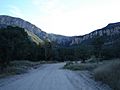
Carr Canyon in the Huachuca Mountains
-
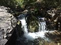
Ramsey Canyon
-
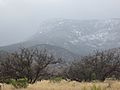
Snow-capped mountains outside Sierra Vista

.jpg)

See also
 In Spanish: Sierra Vista para niños
