
Aralar Range facts for kids
Quick facts for kids Aralar Range |
|
|---|---|

View of the Aralar mountains from Txindoki
|
|
| Highest point | |
| Peak | Irumugarrieta |
| Elevation | 1,431 m (4,695 ft) |
| Dimensions | |
| Area | 208 km2 (80 sq mi) |
| Geography | |
| Country | Spain |
| Range coordinates | 43°00′00″N 2°02′00″W / 43.000063°N 2.033398°W |
| Geology | |
| Type of rock | Karst |
The Aralar Range is a group of mountains in the Basque Mountains of northern Spain. Part of this range in Gipuzkoa became a special protected area called Aralar Natural Park in 1994. Besides its beautiful nature and fun activities, the Aralar Range is also famous for many old Basque stories and legends.
Contents
What's in a Name?
The name 'Aralar' might come from two Basque words: '(h)aran', meaning 'valley', and 'larre', meaning 'graze-land'. In Spanish, these mountains are also known as Sierra de Aralar.
Where is it?
The Aralar Range covers about 208 square kilometers (80 square miles). A large part of this, about 110 square kilometers (42 square miles), is a protected park. The mountains are in the northern part of Spain, right where the provinces of Gipuzkoa and Navarre meet. They act like a natural border between these two areas.
The city of Pamplona is about 40 kilometers (25 miles) to the southeast. The coast of the Cantabrian Sea (part of the Bay of Biscay) and the city of San Sebastian are about the same distance to the north. The border with France is about 50 kilometers (31 miles) to the northeast.
Small villages like Beasain, Arbizu, and Ataun are found at the foot of the mountains. At a place called Lizarrusti, you can find a visitor center. This center is the main entrance to the park.
Mountain Features
The Aralar Range is very mountainous. It has large limestone formations. These are typical of the Basque region. The mountains have a special look called "karst." This means that parts of the limestone rock have been dissolved by water. This creates unique shapes like rocky ridges, deep holes called sinkholes, caves, and even underground rivers.
An example of this is the Mendukillo cavern in the village of Astitz, which you can visit. This cracked and watery land has inspired many old myths and stories.
How the Mountains Formed
The main materials in the Aralar Range are clay, marl, sandstone, and limestone. Most of these rocks are very old, from the Jurassic and Cretaceous periods. The original limestone reefs make the mountains look rugged and strong. You can see this in peaks like Txindoki.
Water in the Mountains
Many streams start in the Aralar Range. Between the peaks, there are four large basins: Agauntza, Zaldibia, Ibiur, and Amezketa. Streams can form in these areas. Because of the karst landscape, some rivers flow underground. These waterways are important for the local economy, for example, by helping to make hydroelectric power.
Weather in Aralar
The Basque region usually has a mild, oceanic climate. The Aralar Range's weather is a mix of the wet climate from Gipuzkoa and the drier climate from Navarre. However, the mountains create their own special weather. They get more rain and have more clouds. Sometimes, thick mists can make hiking in the park a bit tricky.
A Look Back in Time
Very old stone structures, called megalithic monuments, show that people lived in the Aralar Range long ago. These include burial mounds, stone circles, and tall standing stones called menhirs. There are 17 of these on the Gipuzkoan side and 44 on the Navarrese side.
Archaeologists believe that people started raising animals here during the Neolithic period. For example, the old forests have been replaced by pastures for animals. Also, many local legends and folk tales grew from the unique landscape of these mountains.
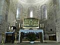
The Sanctuary of San Miguel

The Sanctuary of San Miguel in Excelsis is a very old Romanesque church. It is located in the southern part of the range, near the town of Uharte-Arakil. Records show the church existed as early as the 11th century (around 1032). It is an important part of Christian history in northern Spain. San Miguel is one of the oldest and most important saints for the Basques.
There was an even older church on this spot from the 9th century. After a fire in the 10th century, the church was rebuilt. Inside, the altar has a beautiful enameled front showing Our Lady. Nearby, in a cave, there is a 12th-century shrine to San Miguel.
There's a famous legend about the church. A knight named Teodosio of Goni accidentally killed his own parents. To make up for it, he chained himself to Mount Aralar. An angel, the archangel Michael, appeared and freed him. The angel left behind a special image.
What People Do Here
Hiking and Caving
The Aralar Range has many trails, famous spots, and unique places to explore. The karst landscape, with its caves and holes, is perfect for caving.
Farming and Animals

From May to November, animals graze in the park's pastures. These include latxa sheep, whose milk is used to make Idiazabal cheese, dairy cows, and a group of wild horses. Even though most of the range is empty, some people who live in Aralar move around with their animals. They tend their sheep in the higher parts of the mountains during summer. Shepherds have small huts there. In winter, the animals move closer to the villages.
Local Communities
About 5,112 people live in villages around the range. These villages include Abaltzisketa, Amezketa, Ataun, Zaldibia, and Bedaio. People here work in farming, in factories in bigger towns, and in tourism.
Animals of Aralar
.jpg)
Mammals
Animals living in the range include European minks, roe deer, wild boars, and smaller mammals like Pyrenean desmans and European snow voles.
Birds

Many types of birds live here. You can see griffons, Egyptian vultures, golden eagles, and bearded vultures. Other birds include Alpine choughs, wood pigeons, and black woodpeckers.
Plants of Aralar
The Aralar Range is well-known for its beautiful beech forests. Long ago, people used beech trees to make charcoal. You can also find groves of rowan and hawthorne trees, and Cantabrian holm oak.
Mountains of Aralar
The Dome of Ataun
This is a scenic flat area formed by several peaks. These include Jentilbaratza, Aizkoate, and Arastortz.
Txindoki

This is the most famous and visited peak in the range. It is sometimes called "Little Cervine" or the 'Basque Matterhorn'.
Intzeko Torrea
Also known as “Irumugarrieta”, this is the highest mountain in the Aralar Range.
Best Known Peaks
- Aldaon (1,411m)
- Artubi (1,262m)
- Artxueta (1,343m)
- Balerdi (1,195m)
- Beoain (1,359m)
- Ganboa (1,412m)
- Irumugarrieta (1,431m)
- Pardarri (1,393m)
- Putterri (1,299m)
- Uarrain (1,346m)
- Txindoki or Larrunarri (1,346 m)
Images for kids
-
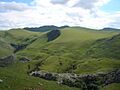
The Aralar fields from Txindoki
-
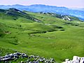
Alotza meadows and Aizkorri in the background
-
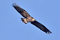
Golden eagle
-

European mink
-
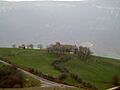
San Miguel de Aralar Sanctuary
-
Inside the apse of San Miguel de Aralar


See also
 In Spanish: Sierra de Aralar para niños
- The Aralar Party is named after the range.
