Averill, Vermont facts for kids
Quick facts for kids
Averill, Vermont
|
|
|---|---|

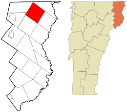
Location in Essex County and the state of Vermont.
|
|

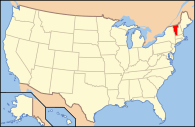
Location of Vermont with the U.S.A.
|
|
| Country | United States |
| State | Vermont |
| County | Essex County |
| Government | |
| • Type | Unincorporated town |
| Area | |
| • Total | 38.1 sq mi (98.6 km2) |
| • Land | 36.0 sq mi (93.3 km2) |
| • Water | 2.0 sq mi (5.3 km2) |
| Elevation | 1,697 ft (517 m) |
| Population
(2020)
|
|
| • Total | 21 |
| • Density | 0.5/sq mi (0.2/km2) |
| Time zone | UTC-5 (EST) |
| • Summer (DST) | UTC-4 (EDT) |
| ZIP codes |
05901 (Averill)
05907 (Norton) |
| FIPS code | 50-009-02125 |
| GNIS feature ID | 1462029 |
Averill is a very small, unincorporated town in Essex County, Vermont, United States. An unincorporated town means it does not have its own local government like most towns do. Instead, its affairs are managed by the Unified Towns & Gores of Essex County.
The town was named after Samuel Averill, who owned land there a long time ago. Averill has never had a large enough population to become a formally incorporated town. In 2020, only 21 people lived there. It is part of the Berlin, New Hampshire micropolitan area.
History
Averill was first planned out in 1762. This happened when Benning Wentworth, the Royal Governor of the Province of New Hampshire, approved its creation. Averill was set up with 23,040 acres of land. This land was divided into 70 equal parts.
There was a rule that people who received land had to farm at least a tenth of it within five years. Also, all large pine trees suitable for ship masts had to be saved for that purpose. The first people to settle in Averill arrived in the 1830s. By 1840, only 11 people lived in the town.
In the 1870s, a sawmill was built in the nearby town of Norton. This led to more people moving to Averill. By 1880, the population grew to 48 residents. The Averill Lumber Co. was started in the 1880s. It ran a mill near Great Averill Lake until the mill burned down in 1898.
Geography
Averill is located in the northern part of Essex County. It shares borders with several other towns. To the northeast is Canaan, and to the southeast is Lemington. Bloomfield is at its southernmost point.
To the southwest is Lewis, and to the west is Averys Gore. Norton is to the northwest. The very northern part of Averill is less than 0.5 miles (0.8 km) from the Canada–US border.
Vermont Route 114 goes through the northern tip of Averill. This road leads east 8 miles (13 km) to Canaan village. It also goes west 5 miles (8 km) to Norton.
The town covers a total area of 38.1 square miles (98.6 km2). About 36.0 square miles (93.3 km2) of this is land. The remaining 2.0 square miles (5.3 km2), or 5.40%, is water. Averill is home to three main bodies of water: Great Averill Pond, Little Averill Pond, and Forest Lake. The highest point in Averill is an unnamed mountain peak. It is 2,970-foot (910 m) tall and sits on the border with Lemington in the southeast.
Lakes in Averill
Averill has two main lakes: Big Averill Lake and Little Averill Lake. Big Averill Lake is also sometimes called Great Averill Pond on maps. It is a fairly large, rectangular lake. It measures about 2 miles long and 0.7 miles wide. One side of Big Averill Lake, along Cottage Road, has electricity. The other side, along Jackson Road, does not have power lines. Little Averill Lake is located about 1,000 yards southwest of Big Averill Lake.
Climate
Averill has a type of weather called a humid continental climate. This means it has warm, humid summers and cold, snowy winters. Because it is so far north and quite high up (about 1,699 ft (518 m)), Averill experiences some of the coldest weather in Vermont.
The average daily temperature stays below freezing for five months of the year. The town also gets a lot of snow. The climate here is very similar to nearby places like Island Pond and Connecticut Lakes.
| Climate data for Averill, Vermont, 1991–2020 normals, 2011–2023 extremes: 1699ft (518m) | |||||||||||||
|---|---|---|---|---|---|---|---|---|---|---|---|---|---|
| Month | Jan | Feb | Mar | Apr | May | Jun | Jul | Aug | Sep | Oct | Nov | Dec | Year |
| Record high °F (°C) | 51 (11) |
64 (18) |
76 (24) |
80 (27) |
92 (33) |
89 (32) |
90 (32) |
87 (31) |
88 (31) |
83 (28) |
70 (21) |
59 (15) |
92 (33) |
| Mean maximum °F (°C) | 43.5 (6.4) |
46.8 (8.2) |
54.3 (12.4) |
68.4 (20.2) |
83.3 (28.5) |
85.3 (29.6) |
86.6 (30.3) |
83.9 (28.8) |
81.9 (27.7) |
73.0 (22.8) |
61.7 (16.5) |
49.0 (9.4) |
85.9 (29.9) |
| Mean daily maximum °F (°C) | 21.5 (−5.8) |
24.9 (−3.9) |
34.0 (1.1) |
47.2 (8.4) |
62.2 (16.8) |
70.3 (21.3) |
75.5 (24.2) |
73.9 (23.3) |
66.4 (19.1) |
53.4 (11.9) |
39.6 (4.2) |
28.2 (−2.1) |
49.8 (9.9) |
| Daily mean °F (°C) | 10.9 (−11.7) |
13.6 (−10.2) |
22.8 (−5.1) |
36.9 (2.7) |
50.7 (10.4) |
59.3 (15.2) |
64.4 (18.0) |
62.6 (17.0) |
55.1 (12.8) |
43.1 (6.2) |
31.1 (−0.5) |
19.4 (−7.0) |
39.2 (4.0) |
| Mean daily minimum °F (°C) | 0.2 (−17.7) |
2.2 (−16.6) |
11.5 (−11.4) |
26.6 (−3.0) |
39.1 (3.9) |
48.3 (9.1) |
53.2 (11.8) |
51.2 (10.7) |
43.7 (6.5) |
32.7 (0.4) |
22.6 (−5.2) |
10.6 (−11.9) |
28.5 (−1.9) |
| Mean minimum °F (°C) | −20.3 (−29.1) |
−21.0 (−29.4) |
−13.3 (−25.2) |
10.0 (−12.2) |
24.6 (−4.1) |
32.3 (0.2) |
39.3 (4.1) |
38.3 (3.5) |
28.5 (−1.9) |
19.5 (−6.9) |
−0.3 (−17.9) |
−12.6 (−24.8) |
−25.1 (−31.7) |
| Record low °F (°C) | −30 (−34) |
−32 (−36) |
−25 (−32) |
1 (−17) |
21 (−6) |
28 (−2) |
35 (2) |
35 (2) |
23 (−5) |
11 (−12) |
−10 (−23) |
−29 (−34) |
−32 (−36) |
| Average precipitation inches (mm) | 2.57 (65) |
2.51 (64) |
3.31 (84) |
2.93 (74) |
4.00 (102) |
4.65 (118) |
4.12 (105) |
4.33 (110) |
3.75 (95) |
4.46 (113) |
3.26 (83) |
2.89 (73) |
42.78 (1,086) |
| Average snowfall inches (cm) | 33.5 (85) |
34.0 (86) |
29.2 (74) |
10.9 (28) |
2.0 (5.1) |
0.0 (0.0) |
0.0 (0.0) |
0.0 (0.0) |
0.0 (0.0) |
2.3 (5.8) |
20.8 (53) |
32.1 (82) |
164.8 (418.9) |
| Source 1: NOAA | |||||||||||||
| Source 2: XMACIS (extremes & 2012-2023 snowfall) | |||||||||||||
Demographics
Averill has always had a very small population. Here's how the number of residents has changed over the years:
| Historical population | |||
|---|---|---|---|
| Census | Pop. | %± | |
| 1830 | 1 | — | |
| 1840 | 11 | 1,000.0% | |
| 1850 | 7 | −36.4% | |
| 1860 | 12 | 71.4% | |
| 1870 | 14 | 16.7% | |
| 1880 | 48 | 242.9% | |
| 1890 | 43 | −10.4% | |
| 1900 | 18 | −58.1% | |
| 1910 | 15 | −16.7% | |
| 1920 | 4 | −73.3% | |
| 1930 | 9 | 125.0% | |
| 1940 | 12 | 33.3% | |
| 1950 | 20 | 66.7% | |
| 1960 | 16 | −20.0% | |
| 1970 | 8 | −50.0% | |
| 1980 | 15 | 87.5% | |
| 1990 | 7 | −53.3% | |
| 2000 | 8 | 14.3% | |
| 2010 | 24 | 200.0% | |
| 2020 | 21 | −12.5% | |
| U.S. Decennial Census | |||
In the year 2000, there were 8 people living in Averill. These 8 people made up 3 households and 2 families. The town had a very low population density. This means there were only about 0.2 people per square mile.
All the residents counted in 2000 were White. Also, about 11.1% of the people spoke French at home. This is likely because Averill is close to the Canadian province of Quebec, where French is widely spoken.
Out of the 3 households, one had children under 18 living there. Two households were married couples living together. One household was made up of a single person. The average household had 2.67 people. The average family had 3.50 people.
The population was spread out in terms of age. There were two people under 18 years old. One person was between 18 and 24. Two people were between 25 and 44. One person was between 45 and 64. Finally, two people were 65 years old or older. The average age of residents was 42 years. There were three males and five females in total.
See also
 In Spanish: Averill (Vermont) para niños
 | Jewel Prestage |
 | Ella Baker |
 | Fannie Lou Hamer |

