
Baca County, Colorado facts for kids
Quick facts for kids
Baca County
|
|
|---|---|

The Baca County Courthouse in Springfield.
|
|

Location within the U.S. state of Colorado
|
|
 Colorado's location within the U.S. |
|
| Country | |
| State | |
| Founded | April 16, 1889 |
| Named for | Felipe Baca |
| Seat | Springfield |
| Largest town | Springfield |
| Area | |
| • Total | 2,557 sq mi (6,620 km2) |
| • Land | 2,555 sq mi (6,620 km2) |
| • Water | 2.4 sq mi (6 km2) 0.09%% |
| Population
(2020)
|
|
| • Total | 3,506 |
| • Density | 1.4/sq mi (0.5/km2) |
| Time zone | UTC−7 (Mountain) |
| • Summer (DST) | UTC−6 (MDT) |
| Congressional district | 4th |
Baca County is a county in the southeastern part of Colorado, a state in the United States. In 2020, about 3,506 people lived here. The main town and county seat is Springfield. Baca County is special because it touches the borders of three other states: Kansas, New Mexico, and Oklahoma.
Contents
History of Baca County
Baca County was created by the Colorado government on April 16, 1889. It was formed from the eastern parts of Las Animas County. The county was named after Felipe Baca, an important pioneer and a lawmaker in Colorado's early days.
Early Days and Growth
Before the 1880s, not many people lived or worked in the county. The main activity was along the Santa Fe Trail, a famous old route that crossed the very southeastern corner. In the 1910s, there was more rain, which helped farming. People could also claim more land to farm, which is called "homesteading." World War I also made people need more farm products. When the Santa Fe Railroad arrived in 1926, new towns grew, and more people moved to the area.
The Dust Bowl Era
The 1930s brought the terrible Dust Bowl. Baca County was one of the places hit hardest by huge dust storms. This led the U.S. government to start programs to help save the soil. They bought farmland to turn it back into natural grasslands. Today, the U.S. Forest Service looks after about 220,000 acres of Comanche National Grassland. This land was bought during the 1930s to help the environment. Places like Carrizo Creek and Picture Canyon are part of these grasslands. Colorado Parks and Wildlife also takes care of fun outdoor areas at Two Buttes Lake and Turk's Pond.
Baca County Tornado
On May 18, 1977, a very strong tornado, called an F4 tornado, hit the southeastern part of Baca County. It caused about $2.5 million in damage. This tornado started in Keyes, Oklahoma. As of 2020, this was the only F4 or EF4 tornado ever recorded in Colorado since 1950.
Geography of Baca County
Baca County covers a total area of about 2,557 square miles. Most of this area, about 2,555 square miles, is land. Only a small part, about 2.4 square miles, is water.
Neighboring Counties
Baca County shares its borders with several other counties:
- Prowers County, Colorado (to the north)
- Stanton County, Kansas (to the east)
- Morton County, Kansas (to the east)
- Cimarron County, Oklahoma (to the south)
- Union County, New Mexico (to the southwest)
- Las Animas County, Colorado (to the west)
- Bent County, Colorado (to the northwest)
Main Roads
These are the major highways that run through Baca County:
 U.S. Highway 160
 U.S. Highway 385
 State Highway 116
Historic Trail
Population of Baca County
The number of people living in Baca County has changed over the years.
| Historical population | |||
|---|---|---|---|
| Census | Pop. | %± | |
| 1890 | 1,479 | — | |
| 1900 | 759 | −48.7% | |
| 1910 | 2,516 | 231.5% | |
| 1920 | 8,721 | 246.6% | |
| 1930 | 10,570 | 21.2% | |
| 1940 | 6,207 | −41.3% | |
| 1950 | 7,964 | 28.3% | |
| 1960 | 6,310 | −20.8% | |
| 1970 | 5,674 | −10.1% | |
| 1980 | 5,419 | −4.5% | |
| 1990 | 4,556 | −15.9% | |
| 2000 | 4,517 | −0.9% | |
| 2010 | 3,788 | −16.1% | |
| 2020 | 3,506 | −7.4% | |
| 2023 (est.) | 3,344 | −11.7% | |
| U.S. Decennial Census 1790-1960 1900-1990 1990-2000 2010-2020 |
|||
In 2000, there were 4,517 people living in the county. The population density was about 2 people per square mile. The median age of people in the county was 43 years old. About 24.5% of the population was under 18 years old.
Important Services
The Southeast Colorado Hospital serves the town of Springfield and the surrounding area. The Springfield Municipal Airport is located just north of Springfield.
Towns and Communities
Towns
- Campo
- Pritchett
- Springfield (This is the county seat, where the main government offices are)
- Two Buttes
- Vilas
- Walsh
Unincorporated Communities
These are smaller communities that are not officially organized as towns.
- Bartlett
- Deora
- Lycan
- Stuart
- Utleyville
Gallery
-
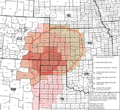
This map shows the areas affected by the Dust Bowl in the 1930s.
-
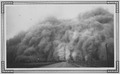
A dust storm in Baca County on Easter Sunday, 1935.
.svg)
See also
 In Spanish: Condado de Baca para niños
