
Bahía de Ponce facts for kids
Quick facts for kids Bahía de Ponce |
|
|---|---|
| Ponce Bay | |

Partial view of Bahia de Ponce, with Isla de Gatas on the left, Isla Cardona on the far background and Punta Peñoncillo on the right (photo taken looking WSW from La Guancha)
|
|

Bahía de Ponce
Location in Puerto Rico
|
|
| Location | Ponce, Puerto Rico |
| Coordinates | 17°58′28.5954″N 66°38′9.168″W / 17.974609833°N 66.63588000°W |
| Type | Bay |
| Etymology | Municipality of Ponce |
| Primary inflows | Rio Matilde |
| River sources | Rio Matilde |
| Ocean/sea sources | Caribbean Sea |
| Basin countries | Puerto Rico |
| Managing agency | Ponce Municipal Government |
| Max. length | 1.5 mi (2.4 km) |
| Max. width | 3.5 mi (5.6 km) |
| Surface area | 5.25 sq mi (13.6 km2) |
| Average depth | 36 ft (11 m) |
| Max. depth | 50 ft (15 m) |
| Salinity | 35.7 |
| Shore length1 | 4.0 mi (6.4 km) |
| Islands | Isla Cardona, Isla de Gatas |
| Settlements | Barrio Playa, Ponce |
| 1 Shore length is not a well-defined measure. | |
.png)
Bahía de Ponce, also known as Ponce Bay, is a beautiful bay located in Barrio Playa, Ponce, Puerto Rico. This bay is very important because it hosts the main commercial harbor on Puerto Rico's southern coast. It is also the second largest port in all of Puerto Rico. The Cardona Island Light stands in the bay, guiding ships safely into the harbor.
Bahía de Ponce is found in the southern part of Puerto Rico. It stretches about 3.5 miles (5.6 km) wide and 1.5 miles (2.4 km) long. The shoreline measures around 4.0 miles (6.4 km). The bay covers an area of about 5.25 square miles (13.6 km²). The water depth usually ranges from 20 to 40 feet (6 to 12 meters). However, near the main piers, it can reach up to 50 feet (15 meters) deep.
This bay offers many fun activities like recreation, sightseeing, and tourist attractions. It is also a hub for important business and industrial work. You can find the Rafael Cordero Santiago Port of the Americas here. Other popular spots include the La Guancha Recreational and Cultural Complex, the La Guancha Boardwalk, and Club Náutico de Ponce. Every September, the exciting Cruce a Nado Internacional swimming event takes place in this bay.
Contents
History of Ponce Bay

The story of Bahía de Ponce is closely linked to Barrio Playa. This community grew along the bay's shores. Since the bay was the main way for people to connect with the outside world, Barrio Playa's history is as old as the city of Ponce itself. This goes back to the 1500s.
In the 1600s and 1700s, the area faced challenges from the sea. There were attempts to attack the small port settlement of Playa. A lookout post was built on El Vigia Hill. This helped warn the city of Ponce if help was needed at the harbor. Despite these threats, the Port of Ponce began operating in February 1789. It quickly became Puerto Rico's most important port.
Threats from the sea continued. For example, in 1800 and 1801, British warships tried to capture the settlement. But the local guards and militia successfully defended it. The Port of Ponce was officially established in 1804 by the Spanish Crown. However, it wasn't until 1811 that Ramon Power y Giralt helped make this happen. The port was built using local funds. Unlike other ports in Puerto Rico, the Ponce Municipal Government manages it.
The waters of Bahía de Ponce also saw a lot of piracy during this time. In 1825, a famous pirate named Roberto Cofresí was caught here. Spanish ships and an American schooner worked together to find him.
By the 1830s, La Playa had one of Puerto Rico's best roads, now called Avenida Hostos. This road connected the port to the city. La Playa became the center of Ponce's business activities. Many new ideas and improvements often happened in La Playa first. For instance, it was the first area in Ponce to get a phone line. It also had the first railroad service from downtown Ponce.
In 1845, a large fire destroyed much of Barrio Playa. It also damaged the Spanish Customs House. This was one of the few buildings left standing. The fire burned down many important buildings at the "Marina de Ponce" (Ponce port).
Later, the Spanish government built lighthouses to help guide ships. The Caja de Muertos Light was built in 1887. The Cardona Island Light followed in 1889. Both lighthouses are on islands near the bay's entrance.


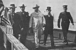
In 1898, Bahía de Ponce was where the United States forces entered Puerto Rico. This happened on July 27. The Port of Ponce had better facilities than other ports on the island. Its harbor could handle large ships. U.S. President Theodore Roosevelt also used the bay for his visit on November 21, 1906. A new pier was built for his visit, but it no longer exists.
By 1913, Playa was a busy neighborhood. It had a population of 5,169 people. The area had wooden houses, sugar cane farms, churches, schools, and hospitals. It also had local industries that created many jobs. Playa was even called "Puerto Rico's first planned suburban area."
As of 2009, Barrio Playa was a working-class neighborhood. It featured a modern shopping mall and a four-star hotel. There were also many parks and sports facilities. Its bay continued to be home to a very important commercial harbor.
Geography of the Bay
.jpg)
The Bahía de Ponce is bordered by Punta Cucharas to the west. To the east, it's bordered by Punta Carenero. The Caribbean Sea is to the south. To the north are Barrio Playa and Barrio Canas. In the past, both Río Portugués and Río Matilde flowed into the bay. Today, only Río Matilde does. El Tuque beach is just west of the bay. Isla de Gatas Inlet is right to the east.
Land areas like Punta Peñoncillo and Isla de Gatas protect the bay. They shield it from the strong east winds. However, the bay is open to the Caribbean Sea from the south. Isla Cardona is a small island in the middle of the bay's entrance. It is home to the Cardona Island Light, a lighthouse. Isla de Gatas is located south of the Port of Ponce piers. This island was once surrounded by water. But in the 1960s, a dike connected it to mainland Puerto Rico.
The construction of the Port of the Americas has added 70 acres of land to the bay area.
Water Features and Currents
,_Ponce,_PR_(DSC05629).jpg)
The seabed at Bahía de Ponce extends over 5 miles (8 km) wide. After this, it drops steeply into the deep Venezuelan Basin.
There are several underwater obstacles for ships entering the bay. These include areas like Bajo Tasmanian, Bajo Cardona, and Isla de Ratones. Bajo Tasmanian is a mile-long bank with shallow depths. Bajo Cardona extends from Isla de Cardona with depths of 12 to 16 feet (3.7 to 4.9 meters).
The main entrance to the bay is east of Isla de Cardona. It has a wide channel that is 36 feet (11 meters) deep. This channel leads to a turning basin for large ships. Smaller boats can use a narrower channel between Isla de Cardona and Las Hojitas.
Ocean Environment
.jpg)
Bahía de Ponce is located between Cabo Rojo Light to the west and Punta Tuna Light to the east. The bay is about 3.5 miles (5.6 km) wide and 1.5 miles (2.4 km) long. Its shoreline is approximately 4.0 miles (6.4 km) long. The total area is about 3300 acres (13.4 km²). Water depths typically range from 20 to 40 feet (6 to 12 meters). However, near the piers, depths can reach 50 feet (15 meters).
Winds in Bahía de Ponce usually come from the east. They often have a southeast direction towards the shore. The average wind speed is about 7.7 miles per hour (12.4 km/h) all year. March is usually the windiest month. The bay receives about 32 inches (81 cm) of rain each year. The average tide is about 1.1 feet (0.34 meters) high. Surface water currents generally flow northeast. The main flow of surface waters moves towards the shore in a northwest direction.
In the past, untreated wastewater entered the bay. To protect the environment, improvements were made. In the mid-1970s, a new pipe was built to discharge wastewater 5,000 feet (1,500 meters) into the sea. Further enhancements in 2001 extended this pipe even deeper. Studies showed that these changes helped keep the bay's water clean. A 2017 study also confirmed that wastewater discharges did not harm endangered species or their habitats in the bay.
Amazing Bay Wildlife


Many interesting animals call Bahía de Ponce home. You can often see brown pelicans, especially near La Guancha Boardwalk. Seagulls are also common. Among the fish, the Atlantic tarpon (Megalops atlanticus) is easy to spot at Paseo Tablado La Guancha.
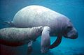
Two endangered species are also found here. The Antillean manatees feed in the bay. Most sightings happen near the Río Matilde estuary. Brown pelicans also feed and rest throughout the bay. They sometimes come ashore at La Guancha Boardwalk looking for food. These pelicans nest at Isla del Frío and rest at the Punta Cucharas end of the bay.
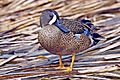
Other birds include the western sandpiper (Calidris mauri). It rests in the western part of the bay. You might also see the roseate tern (Sterna dougallii dougallii). The piping plover (Charadrius melodus) and the Puerto Rican nightjar (Caprimulgus noctitherus) are also present. The blue-winged teal (Anas discors) and the white-cheeked pintail (Anas bahamensis) visit the bay too.
At the Punta Cucharas end of the bay, you can find the Puerto Rican oriole (Icterus portoricensis). The peregrine falcon (Falco peregrinus) and the Puerto Rican vireo (Vireo latimeri) are also there.
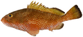
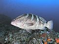
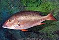
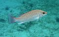
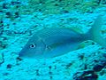
The bay's marine life is rich and diverse. It includes fish like coney (Epinephelus fulvus) and red hind (Epinephelus guttatus). You can also find Nassau grouper (Epinephelus striatus) and various snappers. These include mutton snapper (Lutjanus analis), schoolmaster snapper (Lutjanus apodus), gray snapper (Lutjanus griseus), silk snapper (Lutjanus vivanus), and yellowtail snapper (Ocyurus chrysurus).
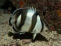
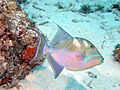
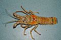
Other marine creatures include white grunt (Haemulon plumierii) and banded butterflyfish (Chaetodon striatus). There are also queen triggerfish (Balistes vetula) and squirrelfish (Holocentrus ascensionis). You might spot sand tilefish (Malacanthus plumieri) and redtail parrotfish (Sparisoma chrysopterum). Trunkfish (Lactophrys quadricomis) also live here. Important shellfish include spiny lobster (Panulirus argus) and queen conch (Strombus gigas).
Maritime Services

The Port of Ponce facilities are located on Punta Peñoncillo, in the eastern part of the bay. The Port of the Americas has a depth of 50 feet (15 meters). This makes it the deepest port in the Caribbean. The port has large cranes that can handle huge ships.
Government services in the bay area include the Ponce Customs House. The U.S. Coast Guard also has a presence here. Their office is in the old Spanish Capitania del Puerto building. There is also a local police precinct and the Maritime Unit of the Policia de Puerto Rico. These services work alongside the Puerto Rico Ports Authority.
Ships usually anchor northeast of Isla de Cardona. The water there is 30 to 50 feet (9 to 15 meters) deep. Smaller boats can anchor northeast of Las Hojitas. A safe spot for small boats is also northeast of the Club Nautico de Ponce yacht club. Bahía de Ponce is not a safe place to anchor during a hurricane. This is because it is open to the south. Sailors often go to other bays like Guayanilla or Guanica for hurricane protection.
Industrial Activities

The Port of Ponce supports many industries through its shipping activities. Several businesses have also set up near the bay. In the 1970s, a tuna fish packing plant operated here. However, it has since closed down.
Fun Recreational Activities

The bay is a great place for fun activities, including recreational fishing. You can take boat trips from La Guancha to Isla Cardona. Tourists enjoy visiting Isla Cardona for sunbathing, swimming, and hiking to its lighthouse. Isla Cardona is part of the Punta Cucharas Nature Reserve. Other boats take visitors to the nearby Caja de Muertos island.
More fun can be found at the La Guancha Recreational Complex. The members-only Club Náutico de Ponce also offers activities. Some cruise ship lines even make stops at the Port of Ponce.
The annual Cruce a Nado Internacional swimming event happens every September. Participants are taken to Isla Cardona. From there, they swim across the bay to the shore in front of Parque Enrique González park. This event follows international swimming rules.
Images for kids
Marine life
-
Antillean manatee (Trichechus manatus)
-
Red hind (Epinephelus guttatus)
-
Nassau grouper (Epinephelus striatus)
-
Mutton snapper (Lutjanus analis)
-
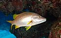
Schoolmaster snapper (Lutjanus apodus)
-
Gray snapper (Lutjanus griseus)
-
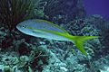
Yellowtail snapper (Ocyurus chrysurus)
-
White grunt (Haemulon plumierii)
-
Banded butterflyfish (Chaetodon striatus)
-
Queen triggerfish (Balistes vetula)
-

Redtail parrotfish (Sparisoma chrysopterum)
-
Caribbean spiny lobster (Panulirus argus)
-
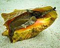
Queen conch (Strombus gigas)


.jpg)


.jpg)
Marine birds
-
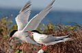
Roseate tern (Sterna dougallii dougallii)
-
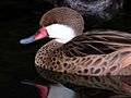
White-cheeked pintail (Anas bahamensis)
-
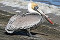
Brown pelican (Pelecanus occidentalis)
-
Blue-winged teal (Anas discors)
-
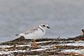
Piping plover (Charadrius melodus)
-
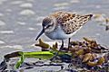
Western sandpiper (Calidris mauri)


.jpg)

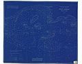
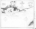
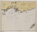
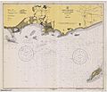
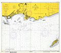
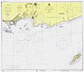
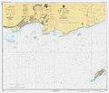
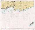
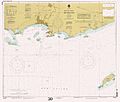
Maps
-
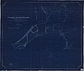
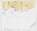
October 1898 map of Bahía de Ponce
-
March 1899 map of Bahía de Ponce
-
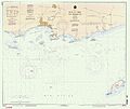
December 1903 map of Bahía de Ponce
-
December 1929 map of Bahía de Ponce
-
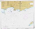
January 1940 map of Bahía de Ponce
-
July 1971 map of Bahía de Ponce
-
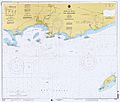
June 1975 map of Bahía de Ponce
-
March 1979 map of Bahía de Ponce
-
February 1984 map of Bahía de Ponce
-
December 1985 map of Bahía de Ponce
-
December 1991 map of Bahía de Ponce
-
September 1996 map of Bahía de Ponce
-
February 1998 map of Bahía de Ponce
-
November 2000 map of Bahía de Ponce
-
May 2003 map of Bahía de Ponce
-
October 2012 map of Bahía de Ponce
.jpg)
.jpg)
.jpg)
.jpg)
.jpg)
.jpg)
.jpg)
.jpg)
.jpg)
.jpg)
.jpg)
.jpg)
.jpg)
.jpg)
.jpg)
.jpg)
Other Views
-
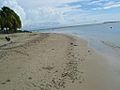
Beach at Bahía de Ponce (Club Náutico)
-
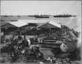
Ships at Bahía de Ponce in 1899
.jpg)
See also
- List of rivers of Ponce, Puerto Rico
- San Juan Bay
- Mayagüez Bay
