Barrow Island (Western Australia) facts for kids

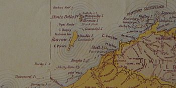
Barrow Island from an 1897 map, showing the Australian mainland on the bottom right (south-east) and the Montebello Islands to the north
|
|
| Lua error in Module:Location_map at line 416: Malformed coordinates value.
Barrow Island (Western Australia)
|
|
| Geography | |
|---|---|
| Location | Indian Ocean, off the Pilbara coast of Western Australia |
| Coordinates | Lua error in Module:Coordinates at line 614: attempt to index field 'wikibase' (a nil value). |
| Area | 202 km2 (78 sq mi) |
| Length | 27 km (16.8 mi) |
| Width | 11.5 km (7.15 mi) |
| Coastline | 72 km (44.7 mi) |
| Administration | |
|
Australia
|
|
| State | Western Australia |
Barrow Island is a large island located about 50 kilometers (31 miles) northwest of the Pilbara coast in Western Australia. It covers an area of 202 square kilometers (78 square miles). This makes it the second largest island in Western Australia, after Dirk Hartog Island.
Contents
Discovering Barrow Island's Past
Barrow Island has a long history. Indigenous Australians visited the island over 4,000 years ago. The island became separated from the mainland about 6,800 years ago. Stone tools and pieces of rock have been found on Barrow Island. These discoveries show that people lived there a very long time ago. Other nearby islands, like Thevenard Island, also show signs of early human visits.
European Explorers Arrive
European sailors first noticed the island in the early 1600s. In 1803, Nicholas Baudin saw it but thought it was part of the Australian mainland. Later, in 1816, Phillip Parker King officially named the island. He named it after Sir John Barrow, 1st Baronet, who was an important person in the British Navy and helped start the Royal Geographical Society.
Early Activities on the Island
From the early 1800s, whalers often visited the area. They used the island between 1842 and 1864. Later, in the 1870s, the island was used in connection with the pearling industry on the mainland.
In 1883, a valuable natural fertilizer called guano was found on Barrow Island. Mining for guano continued through the 1880s. It was then sold to markets in Perth.
Barrow Island's Amazing Environment
Barrow Island is famous for its flat spinifex grasslands. These grasslands are dotted with many termite mounds. The island's main landscape feature is its rolling limestone hills. Around the island, you'll find sandy beaches, rocky shores, low cliffs, sand dunes, salt flats, and reefs.
A Special Nature Reserve
Because it is far from the mainland, Barrow Island is a very important place for conservation. It is an "A-class" reserve. This is the highest level of protection for public land in Australia. This means it is very hard to get permission for mining or other big projects on the island. However, in 2003, a small part of the reserve was set aside for the Gorgon gas project.
Unique Wildlife on Barrow Island
The island is home to many different mammals. Some of these species are now rare or have disappeared from mainland Australia. There are 13 mammal species on the island, including:
- The spectacled hare-wallaby
- The burrowing bettong
- The golden bandicoot
- The black-flanked rock-wallaby
- The Barrow Island euro (a type of eastern wallaroo)
- The Barrow Island mouse
The island also has 43 types of reptiles. These include dragons, geckos, snakes, and monitors. The largest lizard on the island is the perentie. It is the island's top predator. Barrow Island is also an important nesting place for green sea turtles and flatback sea turtles.
Protecting the Island's Nature
While some non-native species like the American cockroach exist, most of the island's animals are still thriving. In 1990, black rats were found on the island, but they were successfully removed. Today, the main threats to the island's wildlife include:
- Invasive species like weeds and feral cats
- Land clearing for development
- Fires
- Diseases
Hidden Underground Worlds
Barrow Island has amazing limestone caves. These caves are home to unique underground creatures. Many of these species are found nowhere else in the world. They include tiny crustaceans and special cave fish. Some of these fish are blind, like the blind cave eel (Ophisternon candidum). There are also strange creatures called troglofauna in the caves. These include a spider-like creature called Draculoides bramstokeri. Scientists think that gases from a "Barrow fault" might help these underground communities survive.
Birds of Barrow Island
BirdLife International has named Barrow Island an Important Bird Area. This means it's a crucial spot for birds.
- The Barrow Island black-and-white fairy-wren is a special type of white-winged fairy-wren. It lives only on this island and is considered vulnerable.
- The island also supports over 1% of the world's population of several bird species. These include the grey-tailed tattler, red-necked stint, pied oystercatcher, and fairy tern.
- An isolated group of spinifexbirds also lives here.
Conservation Efforts
The Western Shield project is working to reduce the impact of introduced species in the region. Companies and the state government are working together. They are studying the island's unique underground animals, which are not well known.
Energy Resources on Barrow Island
Barrow Island is important for Australia's energy supply.
Oil Production
In 1964, oil was found on the island in large amounts. Soon after, the first oil field was set up. By 1995, there were 430 wells producing oil and natural gas on the southern part of the island. Barrow Island has been Australia's top oil producer.
Oil tankers are filled using a special underwater pipeline. This pipeline stretches 10 kilometers (6.2 miles) out into the ocean. There is also a 200-room apartment complex for workers on the island. A private airport was also built. It helps transport workers and equipment from Karratha and Perth.
Natural Gas Development
In December 2009, a group of companies (Chevron, ExxonMobil, and Shell) got permission to develop natural gas reserves. These reserves are located 60 kilometers (37 miles) north of the island. This huge project is called the Gorgon gas project. It was finished in 2017. It holds an estimated 40 trillion cubic feet of gas. This makes it one of Australia's largest energy projects.
Barrow Island's Climate
Barrow Island has a hot desert climate. Summers are very hot and humid, with rainfall that can vary a lot. Winters are warm and dry.
| Climate data for Barrow Island Airport (20º52'S, 115º25'E, 6 m AMSL) (1999-2024 and extremes) | |||||||||||||
|---|---|---|---|---|---|---|---|---|---|---|---|---|---|
| Month | Jan | Feb | Mar | Apr | May | Jun | Jul | Aug | Sep | Oct | Nov | Dec | Year |
| Record high °C (°F) | 45.0 (113.0) |
41.2 (106.2) |
40.3 (104.5) |
38.2 (100.8) |
33.8 (92.8) |
30.9 (87.6) |
29.2 (84.6) |
33.3 (91.9) |
36.0 (96.8) |
39.5 (103.1) |
40.0 (104.0) |
42.4 (108.3) |
45.0 (113.0) |
| Mean daily maximum °C (°F) | 33.2 (91.8) |
33.7 (92.7) |
33.5 (92.3) |
31.3 (88.3) |
27.5 (81.5) |
24.3 (75.7) |
23.8 (74.8) |
25.2 (77.4) |
27.2 (81.0) |
29.6 (85.3) |
30.6 (87.1) |
32.3 (90.1) |
29.4 (84.8) |
| Mean daily minimum °C (°F) | 25.8 (78.4) |
26.3 (79.3) |
26.6 (79.9) |
24.6 (76.3) |
21.3 (70.3) |
18.8 (65.8) |
17.5 (63.5) |
17.9 (64.2) |
19.7 (67.5) |
21.8 (71.2) |
23.0 (73.4) |
24.5 (76.1) |
22.3 (72.2) |
| Record low °C (°F) | 21.0 (69.8) |
21.5 (70.7) |
21.0 (69.8) |
19.0 (66.2) |
14.3 (57.7) |
12.8 (55.0) |
11.8 (53.2) |
12.2 (54.0) |
14.7 (58.5) |
16.0 (60.8) |
18.0 (64.4) |
19.8 (67.6) |
11.8 (53.2) |
| Average precipitation mm (inches) | 20.7 (0.81) |
43.2 (1.70) |
53.3 (2.10) |
34.1 (1.34) |
60.1 (2.37) |
34.7 (1.37) |
13.1 (0.52) |
3.5 (0.14) |
1.2 (0.05) |
1.6 (0.06) |
1.5 (0.06) |
6.1 (0.24) |
271.3 (10.68) |
| Average precipitation days (≥ 1.0 mm) | 2.0 | 2.3 | 2.4 | 1.5 | 2.6 | 1.9 | 1.0 | 0.6 | 0.2 | 0.2 | 0.2 | 0.6 | 15.5 |
| Average afternoon relative humidity (%) | 58 | 59 | 59 | 53 | 55 | 56 | 58 | 52 | 51 | 51 | 52 | 54 | 55 |
| Average dew point °C (°F) | 21.9 (71.4) |
22.7 (72.9) |
22.5 (72.5) |
18.8 (65.8) |
16.7 (62.1) |
14.3 (57.7) |
14.1 (57.4) |
13.4 (56.1) |
14.4 (57.9) |
16.2 (61.2) |
17.7 (63.9) |
19.8 (67.6) |
17.7 (63.9) |
| Source: Bureau of Meteorology | |||||||||||||
World Record Wind Speed
Barrow Island holds a world record! The World Meteorological Organization confirmed that the highest non-tornadic wind gust ever recorded happened here. On April 10, 1996, during Severe Tropical Cyclone Olivia, winds reached an incredible 408 kilometers per hour (254 mph). This broke the previous record set in 1934 in the United States.


