
Barton, Vermont facts for kids
Quick facts for kids
Barton, Vermont
|
|
|---|---|
|
Town
|
|

Aerial view of Barton
|
|

Located in Orleans County, Vermont
|
|

Location of Vermont with the U.S.A.
|
|
| Country | United States |
| State | Vermont |
| County | Orleans |
| Chartered | October 20, 1789 |
| Communities | |
| Area | |
| • Total | 44.9 sq mi (116.3 km2) |
| • Land | 43.7 sq mi (113.1 km2) |
| • Water | 1.3 sq mi (3.3 km2) |
| Elevation | 931 ft (353 m) |
| Population
(2020)
|
|
| • Total | 2,872 |
| • Density | 66/sq mi (25.4/km2) |
| • Households | 1,153 |
| • Families | 748 |
| Time zone | UTC−5 (EST) |
| • Summer (DST) | UTC−4 (EDT) |
| ZIP Codes | |
| Area code | 802 |
| FIPS code | 50-03550 |
| GNIS feature ID | 1462037 |
Barton is a small town in Orleans County, Vermont, United States. In 2020, about 2,872 people lived here. The town has two official villages: Barton and Orleans. About half of the town's people live in these villages. Barton is one of only five towns in Vermont with two official villages.
The Nulhegan Abenaki Tribe, a Native American group recognized by the state, has its main office in Barton.
Contents
History of Barton
Early Native American Life
The Abenaki people and their ancestors lived in this area for about 12,000 years. They were part of a larger group of Native American tribes called the Wabanaki confederacy. These tribes spoke similar languages and lived in areas that are now part of Canada. In 2011 and 2012, the state of Vermont officially recognized four Abenaki tribes, including the Nulhegan Abenaki Tribe.
Early European traders and settlers were mostly French. Later, in the 1700s, people from England and America began to arrive. Both groups often pushed the Abenaki off their lands. Many Native Americans also became sick and died from new diseases brought by the Europeans.
Settlement and Growth
Barton was officially created on October 20, 1789. The land was given to 60 soldiers who fought in the American Revolutionary War. They received land instead of pay. Famous people like Admiral John Paul Jones and General William Barton were among them. The town was named after General William Barton. Before it was officially named Barton, the area was called "Providence."
From 1791 to 1793, Timothy Hinman built a road, now known as the Hinman Settler Road. This road connected Barton to other towns like Greensboro and Derby, and even to Canada. Early settlers found many old wigwams (Native American homes) near Barton pond. This showed that the Abenaki often camped there. One Abenaki man, Foosah, said he hunted many moose, beaver, and otter near the pond in 1783–1784.
Major Events and Development
On June 6, 1810, a lake known as Runaway Pond suddenly flooded the Barton River Valley. This caused a lot of damage, and you can still see signs of it today. In 1824, the town decided to pay for schools for all children. A private school, which later became Barton Academy, opened in 1852.
The railroad reached Barton in 1858, and the first train arrived in 1863. The railroad helped the town grow, just like the interstate highway would later. Stagecoaches also used the new railroad stops.
Before the Civil War, a man named Fred Kimball helped people who had escaped slavery. He was part of the Underground Railroad, a secret network that helped people reach freedom in Vermont or Canada.
During the Civil War, 182 men from Barton volunteered to fight. Later, in 1863, the government started a draft to get more soldiers. People could pay $300 or find someone else to take their place.
Barton had seven granite quarries, which were very important for the town's economy. Around 1900, a quarry near Crystal Lake used steamboats to carry stone across the lake. In winter, they slid barges on the ice.
In 1907, when workers were digging for the new Barton Academy, they found an Abenaki burying ground. Sadly, there are no records of what happened to the items found there.
Barton's population grew steadily, reaching its highest point of 3,506 people in 1920. In 1921, the town celebrated its 125th birthday with a huge show. About 300 townspeople performed for 4,500 people, which was a record for the county! The area where the festival was held is now called Pageant Park.
During World War II, a crude oil pipeline was built through Barton in 1941. This pipeline carried oil from Portland, Maine, to Montreal, Canada. It was built to avoid the danger of German submarines attacking ships at sea.
The last one-room schools in Barton closed in the late 1950s. In 1967, the high schools in Barton and Orleans were too small. So, they became elementary schools, and a new high school, Lake Region Union High School, was built.
In February 2016, Barton experienced extremely cold weather. The temperature dropped to -20°F (-29°C). There wasn't enough snow to keep homes warm, and when the electricity went out for 12 hours, it became very dangerous, especially for older people. Many pipes froze and burst.
South Barton Village
The small village of South Barton, also called Kimball Station, no longer exists. It was located south of Crystal Lake. In 1858, Barton gained this area from Sheffield. South Barton had its own post office in 1861 and a train station in 1874. In the early 1930s, 30 students went to its one-room school.
Logging was the main business in South Barton. The village struggled because it did not get electricity, unlike the other two villages in town. By the early 1940s, South Barton was no longer a thriving place. Its post office closed in 1947. When the main factory moved away, many people left the village.
Geography of Barton
Barton covers about 44.9 square miles (116.3 km2). Most of this area is land, with a small part being water. The town is about 931 feet (284 meters) above sea level.
The main type of rock found here is calciferous mica schist. You can also find some granite and other rocks. Small amounts of iron and even traces of gold have been found.
The highest point in Barton is Barton Mountain, which is 2,235 feet (681 meters) high. May Hill is another peak, at 2,007 feet (612 meters).
Important rivers include the Barton and Willoughby rivers. Many smaller brooks also flow through the town. Each spring, rainbow trout swim up the Willoughby River to lay their eggs in Lake Willoughby.
Crystal Lake State Park is a beautiful park located in Barton.
Population of Barton
| Historical population | |||
|---|---|---|---|
| Census | Pop. | %± | |
| 1800 | 128 | — | |
| 1810 | 447 | 249.2% | |
| 1820 | 372 | −16.8% | |
| 1830 | 726 | 95.2% | |
| 1840 | 852 | 17.4% | |
| 1850 | 987 | 15.8% | |
| 1860 | 1,590 | 61.1% | |
| 1870 | 1,911 | 20.2% | |
| 1880 | 2,364 | 23.7% | |
| 1890 | 2,217 | −6.2% | |
| 1900 | 2,790 | 25.8% | |
| 1910 | 3,346 | 19.9% | |
| 1920 | 3,506 | 4.8% | |
| 1930 | 3,469 | −1.1% | |
| 1940 | 3,371 | −2.8% | |
| 1950 | 3,298 | −2.2% | |
| 1960 | 3,066 | −7.0% | |
| 1970 | 2,874 | −6.3% | |
| 1980 | 2,990 | 4.0% | |
| 1990 | 2,967 | −0.8% | |
| 2000 | 2,780 | −6.3% | |
| 2010 | 2,810 | 1.1% | |
| 2020 | 2,872 | 2.2% | |
| U.S. Decennial Census | |||
In 2000, there were 2,780 people living in Barton. There were 1,153 households, and 748 families. About 32% of households had children under 18. The average household had 2.33 people.
The population's age spread showed that 24.8% were under 18. About 18.4% were 65 years or older. The average age in town was 41 years old.
Economy and Jobs
Money and Tourism
In 2000, the average income for a household in Barton was about $28,797. For families, it was $33,872.
Many people own second homes in Barton, especially for summer visits. About 30% of homes are second homes. This means tourism is an important part of the town's economy.
Local Businesses
Ethan Allen Manufacturing, a furniture company in the village of Orleans, employs about 400 people. A nursing home in town also provides jobs for 70 people.
Services and Utilities
- Phone Service: Landline phones are provided by Consolidated Communications. Cell phone service is available from Verizon and AT&T.
- Electricity: The Barton side of town gets electricity from Barton Electric. This company uses water power to generate some of its electricity for about 2,100 homes. The Orleans side of town gets electricity from The Village of Orleans Electric.
- Water and Sewage: Water and sewage services are provided separately to homes in Barton and Orleans villages.
- Waste: In 2013, Barton produced about 2,000 tons of waste each year.
Getting Around Barton
Main Roads
The opening of Interstate 91 in 1972 (north) and 1978 (south) made it easier to connect with other towns. This led to more trade and new residents. This was similar to how the railroad helped the town grow a century earlier. In 1980, Barton saw its first population increase in 100 years.
Barton has many miles of roads, including paved state roads and dirt roads.
 Interstate 91 connects Barton to Derby.
 U.S. Route 5 also connects Barton to Derby.
 Vermont Route 16 goes from Barton to Westmore (east and north) and to Glover (south).
 Vermont Route 58 goes from Barton to Lowell (west) and to Westmore (east).
Local Transport
Rural Community Transportation offers rides for people who need medical appointments, disabled individuals, and older adults.
Railroads
The Washington County Railroad (part of the Vermont Railway System) runs through Barton about twice a day. However, it does not make regular stops for passengers. The railroad built a special facility in 2015 to transfer goods.
Media and News
- The Chronicle is a newspaper published every week in Barton.
- The Orleans County Monitor was another weekly newspaper published here from 1872 to 1953.
Culture and Fun
Barton has two libraries, one in Barton village and one in Orleans. Three areas in Barton village are listed on the National Register of Historic Places, meaning they are important historical sites.
The Orleans County Fair has been held in Barton almost every August since 1867. It's a big event with lots of fun activities. In 1912, Theodore Roosevelt even visited the fair when he was running for President!
For many years, the fair featured harness racing, which was very popular. In 2009, a state record for horse racing was broken at the fair.
In 2011, the fair set a Guinness World Record! 301 Cadillac cars were in a parade on the opening day. This was much more than the 103 cars needed to break the old record. The person who developed the Cadillac car was born in Barton. In 2013, 18,000 people paid to attend the fair.
Famous People from Barton
Many notable people have connections to Barton:
- Frederick W. Baldwin, a state senator.
- Colonel William Barton, a Revolutionary War officer and the town's namesake.
- Susan Dunklee, a biathlete who grew up in Barton.
- Lee E. Emerson, a former governor of Vermont.
- Josiah Grout, another former governor of Vermont.
- William W. Grout, a US congressman.
- Emory A. Hebard, a former Vermont State Treasurer.
- Stephen Perry Jocelyn, a US Army general.
- Henry M. Leland, an engineer who created the Cadillac and Lincoln car brands.
- Willard W. Miles, a judge on the Vermont Supreme Court.
- Major General Francis W. Nye, a military commander.
- Henry Alexander Stafford, a professional baseball player for the New York Giants.
- Frank D. Thompson, another judge on the Vermont Supreme Court.
Images for kids
-
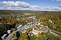
Aerial view of Barton
-
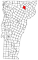
Located in Orleans County, Vermont
-
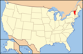
Location of Vermont within the U.S.A.
See also
 In Spanish: Barton (Vermont) para niños
