Bath, New Hampshire facts for kids
Quick facts for kids
Bath, New Hampshire
|
|
|---|---|
|
Town
|
|

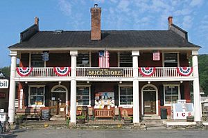
The Brick Store, built 1824
|
|
| Motto(s):
"Covered Bridge Capital of New England"
|
|

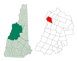
Location in Grafton County, New Hampshire
|
|
| Country | United States |
| State | New Hampshire |
| County | Grafton |
| Incorporated | 1761 |
| Villages | Bath Swiftwater Upper Village |
| Area | |
| • Total | 38.6 sq mi (99.9 km2) |
| • Land | 37.7 sq mi (97.7 km2) |
| • Water | 0.8 sq mi (2.2 km2) 2.23% |
| Elevation | 530 ft (162 m) |
| Population
(2020)
|
|
| • Total | 1,077 |
| • Density | 28/sq mi (11.0/km2) |
| Time zone | UTC-5 (Eastern) |
| • Summer (DST) | UTC-4 (Eastern) |
| ZIP codes |
03740 (Bath)
03785 (Woodsville) |
| Area code(s) | 603 |
| FIPS code | 33-03940 |
| GNIS feature ID | 0873540 |
Bath is a small town in Grafton County, New Hampshire, United States. In 2020, about 1,077 people lived there. Bath is known for its old buildings, like the Brick Store, and its three beautiful covered bridges. Many people visit Bath, and some also live there and travel to nearby Littleton for work. The town includes the village of Swiftwater and part of the area called Mountain Lakes.
Contents
History of Bath
Bath was officially created on September 10, 1761, by Governor Benning Wentworth. He named it after William Pulteney, who was the first Earl of Bath. The first settlers arrived in 1765. However, the original plans for the town weren't fully met, so Governor John Wentworth re-granted the town in 1769. By 1790, 493 people lived in Bath.
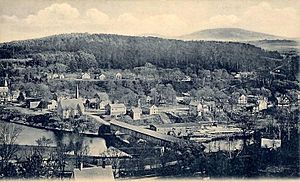
Bath was a very busy and successful village in northern New Hampshire. It was located at the "head of navigation" on the Connecticut River. This meant boats could travel up the river to Bath, making it a good place for trade. The town was also protected by the Green Mountains and White Mountains, which helped shield it from strong winds.
The land around Bath was great for farming, especially the "intervales," which are fertile river plains. The Ammonoosuc and Wild Ammonoosuc rivers provided "water power" for mills. This power helped run factories that made things. By 1830, the town had 1,627 people. Farmers raised many sheep, and people even mined for copper.
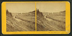
In 1853, the White Mountains Railroad opened. This train line helped Bath send its products, like lumber, potatoes, and livestock, to other places. The town had mills for grinding grain and cutting wood. Other businesses included a wool factory, a creamery (for dairy products), and factories that made starch.
On February 1, 1872, a large fire swept through Bath village. It destroyed the church, a hotel, and many homes. The church was rebuilt the next year. Even with the railroad, a nearby town called Woodsville grew into a major railroad hub. This meant that Woodsville became the main business center for the area, and Bath became quieter.
Because Bath's economy slowed down, many of its old buildings from the 1800s were saved. These buildings show off styles like "Federal" and "Greek Revival" architecture. The Brick Store, built in 1824, was a very important building in the town center for a long time.
Geography of Bath
Bath is located in the northwestern part of New Hampshire, in Grafton County. The town covers about 99.9 square kilometers (about 38.6 square miles). Most of this area is land, with a small part being water. The Connecticut River forms the western edge of the town. The Ammonoosuc and Wild Ammonoosuc rivers also flow through Bath. All the water in Bath eventually flows into the Connecticut River watershed. This means all the rain and river water in Bath ends up in the Connecticut River.
The highest points in Bath are on Gardner Mountain. These spots are a bit taller than 1980 feet (about 604 meters) above sea level. Sea level is the average height of the ocean's surface.
Bath is also located where an ancient lake, called Lake Hitchcock, used to be after the last ice age. This lake helped shape the Connecticut River valley.
You can travel through Bath using U.S. Route 302 and New Hampshire Route 112. The village of Swiftwater is found along Route 112, close to the border with Haverhill.
Population Information
| Historical population | |||
|---|---|---|---|
| Census | Pop. | %± | |
| 1790 | 498 | — | |
| 1800 | 825 | 65.7% | |
| 1810 | 1,316 | 59.5% | |
| 1820 | 1,498 | 13.8% | |
| 1830 | 1,627 | 8.6% | |
| 1840 | 1,591 | −2.2% | |
| 1850 | 1,574 | −1.1% | |
| 1860 | 1,366 | −13.2% | |
| 1870 | 1,168 | −14.5% | |
| 1880 | 1,032 | −11.6% | |
| 1890 | 935 | −9.4% | |
| 1900 | 1,006 | 7.6% | |
| 1910 | 978 | −2.8% | |
| 1920 | 838 | −14.3% | |
| 1930 | 785 | −6.3% | |
| 1940 | 686 | −12.6% | |
| 1950 | 706 | 2.9% | |
| 1960 | 604 | −14.4% | |
| 1970 | 607 | 0.5% | |
| 1980 | 761 | 25.4% | |
| 1990 | 784 | 3.0% | |
| 2000 | 893 | 13.9% | |
| 2010 | 1,077 | 20.6% | |
| 2020 | 1,077 | 0.0% | |
| U.S. Decennial Census | |||
In 2000, there were 893 people living in Bath. There were 350 households, and 253 of these were families. About 29.7% of households had children under 18 living with them. Most households (61.4%) were married couples.
The people in Bath were of different ages. About 24.3% were under 18 years old. The median age was 42 years. This means half the people were younger than 42, and half were older.
Places to See in Bath
Bath has several interesting historical sites:
- The Brick Store is listed on the National Register of Historic Places (NRHP). This means it's an important historical building.
- Covered bridges:
- Bath Covered Bridge (NRHP)
- Haverhill–Bath Covered Bridge (NRHP)
- Swiftwater Covered Bridge (NRHP)
- Goodall-Woods Law Office (NRHP)
- Jeremiah Hutchins Tavern (NRHP)
- There are also two New Hampshire Historical Markers in Bath, which are special signs that tell about important historical events or places.
Famous People from Bath
Some notable people who have lived in Bath include:
- Timothy Bedel (1737–1787), who owned mills and was a military leader.
- Raymond S. Burton (1939–2013), who served for a very long time on the Executive Council of New Hampshire.
- Henry Hancock (1822–1883), a lawyer and land surveyor.
- Harry Hibbard (1816–1872), who was a US congressman.
- James Hutchins Johnson (1802–1887), a businessman and US congressman.
- Patti Page (1927–2013), a famous singer.
- E. Carleton Sprague (1822–1895), a former New York state senator.
- Lillian Carpenter Streeter (1854–1935), a social reformer and writer.
See also
 In Spanish: Bath (Nuevo Hampshire) para niños


