Beaver, Pennsylvania facts for kids
Quick facts for kids
Beaver, Pennsylvania
|
|
|---|---|

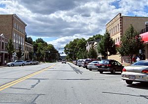
Third Street (Pennsylvania Route 68) within the Beaver Historic District
|
|

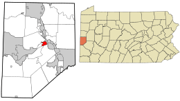
Location in Beaver County and the U.S. state of Pennsylvania.
|
|
| Country | United States |
| State | Pennsylvania |
| County | Beaver |
| Settled | 1792 |
| Incorporated | 1802 |
| Area | |
| • Total | 1.12 sq mi (2.91 km2) |
| • Land | 0.92 sq mi (2.37 km2) |
| • Water | 0.21 sq mi (0.54 km2) |
| Elevation | 791 ft (241 m) |
| Population
(2020)
|
|
| • Total | 4,438 |
| • Density | 4,845/sq mi (1,871/km2) |
| Time zone | UTC-5 (Eastern (EST)) |
| • Summer (DST) | UTC-4 (EDT) |
| Zip Code |
15009
|
| Area code(s) | 724 |
| FIPS code | 42-04688 |
| Website | http://www.beaverpa.us |
Beaver is a small town, called a borough, in Beaver County, Pennsylvania. It is the main town where the county government is located, known as the county seat. Beaver is special because it sits near where two rivers, the Beaver and Ohio Rivers, meet. This meeting point is called a confluence. It's about 30 miles (48 km) northwest of Pittsburgh. In 2020, about 4,438 people lived there.
Contents
History of Beaver
The land where Beaver is now was once home to Shawnee Indians. Later, other groups like the Mingoes and Lenape lived there. This area was part of the Ohio Country, which was fought over during the French and Indian War.
Beaver became important during the American Revolution. A fort called Fort McIntosh was built there. It was a frontier fort for the Patriot soldiers. After the war, the First American Regiment, the oldest active unit in the US Army, stayed at the fort. The fort was taken down in 1788 because it was no longer needed.
The community of Beaver was officially planned in 1792. In 1800, it became the county seat for the new Beaver County. The first county court opened in Beaver in 1804. The town grew steadily, and then much faster after 1879 when the Pittsburgh and Lake Erie Railroad arrived. In 1884, a big flood caused a lot of damage. In 1974, archaeologists dug up the site of Fort McIntosh to learn more about its past. In 1997, Beaver was named a Tree City USA community, which means it cares about its trees.
A man named Robert Linn was the mayor of Beaver for a very long time, 58 years! He served from 1946 to 2004. This made him one of the longest-serving mayors in the entire United States.
Geography of Beaver
Beaver covers about 1.1 square miles (2.9 square kilometers). Most of this area is land, and a small part is water.
Neighboring Towns
Beaver shares its borders with three other towns. To the north is Brighton Township. To the east is Bridgewater. To the west is Vanport Township.
Across the Ohio River to the south, Beaver is close to Monaca (southeast), Center Township (south), and Potter Township (southwest).
People of Beaver
| Historical population | |||
|---|---|---|---|
| Census | Pop. | %± | |
| 1820 | 361 | — | |
| 1830 | 914 | 153.2% | |
| 1840 | 551 | −39.7% | |
| 1850 | 2,054 | 272.8% | |
| 1860 | 817 | −60.2% | |
| 1870 | 1,120 | 37.1% | |
| 1880 | 1,178 | 5.2% | |
| 1890 | 1,552 | 31.7% | |
| 1900 | 2,348 | 51.3% | |
| 1910 | 3,456 | 47.2% | |
| 1920 | 4,135 | 19.6% | |
| 1930 | 5,665 | 37.0% | |
| 1940 | 5,641 | −0.4% | |
| 1950 | 6,360 | 12.7% | |
| 1960 | 6,160 | −3.1% | |
| 1970 | 6,100 | −1.0% | |
| 1980 | 5,441 | −10.8% | |
| 1990 | 5,028 | −7.6% | |
| 2000 | 4,775 | −5.0% | |
| 2010 | 4,529 | −5.2% | |
| 2020 | 4,438 | −2.0% | |
| 2021 (est.) | 4,698 | 3.7% | |
| Sources: | |||
In 2000, there were 4,775 people living in Beaver. There were 2,112 households, which are groups of people living together. About 23% of these households had children under 18. Many households were married couples.
The average age of people in Beaver was 43 years old. About 19% of the population was under 18. About 22% of the population was 65 or older.
The average yearly income for a household in Beaver was about $42,113. For families, it was about $57,208. The average income per person was about $24,003. A small number of families and people lived below the poverty line, which means they had very low incomes.
Arts and Culture
Beaver Historic District
In 1996, almost all of Beaver was listed on the National Register of Historic Places. This means it's a special area with important old buildings. It's called a historic district. The buildings in this district are mostly from the 1800s.
Some important buildings include five churches and the county courthouse. Many homes in the district are also very old. The district also includes the Matthew S. Quay House, which was the home of Senator Matthew Quay. The site of Fort McIntosh is also within this historic area.
Beaver Area Memorial Library
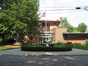
The Beaver Area Memorial Library started small in the 1940s. It was just a collection of books in a bank basement. Later, it moved to a former high school basement. In 1948, it officially became the Beaver Memorial Library.
In 1961, people raised money to build a new library. The new building opened on April 8, 1962. This building is still used as the public library today.
Education
Children living in Beaver go to schools in the Beaver Area School District. This district also serves students from Bridgewater, Brighton Township, and Vanport Township.
The schools in the district are:
- College Square Elementary School – for grades K-2
- Dutch Ridge Elementary School – for grades 3-6
- Beaver Area Middle School – for grades 7-8
- Beaver Area High School – for grades 9-12
Notable People
Many interesting people have come from Beaver:
- Daniel Agnew – A Chief Justice of the Supreme Court of Pennsylvania.
- John Allison – A lawyer and United States Congressman.
- Rudyerd Boulton – An ornithologist, someone who studies birds.
- Robert Linn – The mayor of Beaver for 58 years.
- Amber Mariano – A winner of the TV show Survivor: All-Stars.
- Nate Martin – Co-founder and CEO of Puzzle Break, the first American Escape Room company.
- Tom McCreery – A Major League Baseball player.
- Matthew Quay – A United States Senator.
- Harrison Holt Richardson – The youngest member of an expedition to Antarctica.
- Nina Chermak Rosenberg – An American costume designer.
- Ralph Francis Scalera – A judge for a U.S. District Court.
- Jeff Shaver – A former Major League Baseball player.
- John Skorupan – A former NFL Linebacker for the Buffalo Bills and the New York Giants.
- W. E. Clyde Todd – Another ornithologist who studied birds.
- Florence Wickham – A contralto opera singer.
See also
 In Spanish: Beaver (Pensilvania) para niños
 | Sharif Bey |
 | Hale Woodruff |
 | Richmond Barthé |
 | Purvis Young |


