
Beer, Devon facts for kids
Quick facts for kids Beer |
|
|---|---|
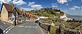
 Beach at Beer, with Beer Head behind (April 2006) |
|

Beer
|
|
| Area | 6.7 km2 (2.6 sq mi) |
| Population | 1,317 (2011) |
| • Density | 197/km2 (510/sq mi) |
| OS grid reference | SY2289 |
| Civil parish |
|
| District |
|
| Shire county | |
| Region | |
| Country | England |
| Sovereign state | United Kingdom |
| Post town | SEATON |
| Postcode district | EX12 |
| Dialling code | 01297 |
| Police | Devon and Cornwall |
| Fire | Devon and Somerset |
| Ambulance | South Western |
| EU Parliament | South West England |
| UK Parliament |
|
Beer is a lovely seaside village in Devon, England. It faces Lyme Bay and is part of the amazing Jurassic Coast World Heritage Site. The village is known for its beautiful cliffs, including Beer Head, which are part of the South West Coast Path.
In 2011, about 1,317 people lived in Beer.
Contents
History of Beer
Beer is a very old village, first mentioned in a famous book called the Domesday Book in 1086. Back then, it had 28 homes. The name "Beer" doesn't come from the drink! It comes from an old English word, bearu, which means "grove" or "wooded area." This tells us that the village was once surrounded by trees.
This coastal village grew up around a secret cove. Long ago, it was a popular spot for smuggling, where people would hide illegal goods in caves. Today, these caves are a fun part of visiting Beer.
Beer is also home to the Beer Quarry Caves. These are huge caves created from digging out "Beer stone." This special stone has been used since Roman times because it's easy to carve and turns a soft yellow color when exposed to air. Beer stone was used to build many famous places, like 24 cathedrals in the UK, including Exeter Cathedral, Westminster Abbey, and St. Paul's Cathedral. It was even used for a cathedral in St. Louis, USA!
About a mile inland, you can find Bovey House, an old Elizabethan manor house. For a long time, the main ways people in Beer made money were by fishing and making lace.
In 2008, something really cool happened: bacteria from Beer's cliffs were sent to the International Space Station! These tiny living things were still attached to small pieces of rock from the Jurassic Coast. After 553 days in space, many of them were still alive! Scientists are now studying these survivors. This experiment helps us learn how microbes can live in extreme conditions. They even found a new type of bacteria that could help future space settlements on the Moon and Mars by making oxygen and breaking down rocks.
What Beer Does Today
Today, Beer's main ways of making money are tourism and fishing. Many people visit the village to enjoy its beauty.
Beer is also home to Pecorama, a popular attraction run by the PECO model railway company. Pecorama has beautiful gardens and the Beer Heights Light Railway, which is a fun miniature train ride.
The special shape of Beer's coastline means that local sailors can go out fishing even when the weather is bad in other towns. This is because Beer Head and the chalk cliffs protect the village from strong winds. Since there isn't a harbor, boats are pulled up onto the beach using winches. You can often buy fresh fish right there! In the past, up to 20 men would operate a large manual capstan to pull the boats in, but now electric winches and tractors do the job.
Beer's Landscape
Many buildings in Beer are made with flint, a hard, shiny stone found in the local chalk rock. A small stream flows openly alongside the main road, winding its way down to the sea. Beer also has a steep pebble beach, perfect for relaxing by the water.
Getting Around Beer
Beer is located just off the A3052 road, which connects Exeter to the west and Lyme Regis to the east.
The closest train station to Beer is Axminster railway station, about 9 kilometers (6 miles) away. This station is on the train line that goes from Exeter to Waterloo. There's a bus that connects the train station to Beer.
Local buses, run by AVMT Buses, serve the village. They can take you to many nearby towns and villages, including Seaton, Axminster, Branscombe, Sidmouth, and Colyton.
Famous People from Beer
- William George Aston (1841–1911), an Irish diplomat and writer, passed away in Beer.
- Frederick T Durrant (1895–c. 1979), an organist, was born in Beer.
- Richard Gush (1789–1858), a settler who moved to South Africa in 1820, was born here.
- Rowland Molony (born 1946), a poet and novelist, lives in Beer.
- Charles William Peach (1800–1886), a naturalist and geologist, lived in Beer.
- Jack Rattenbury (1778–1844), a famous smuggler, was born in Beer.
- Innes FitzGerald (2006– ), an athlete, grew up in Beer.
Images for kids
-
Common Lane
-
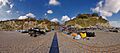
Beach
-
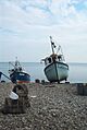
Boats beached at Beer
-
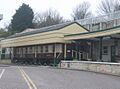
View at the entrance to the Pecorama Pleasure Gardens in Beer, including a restored Golden Arrow train Pullman railway carriage.


See also
 In Spanish: Beer (Devon) para niños
