
Bel Air, Los Angeles facts for kids
Quick facts for kids
Bel Air
|
|
|---|---|

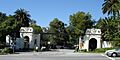
The Bel Air west gate at Sunset and Bellagio
|
|

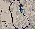
Boundaries of Bel Air as drawn by the Los Angeles Times
|
|

Bel Air
Location in Western Los Angeles
|
|
| Country | |
| State | |
| County | Los Angeles |
| City | Los Angeles |
| Time zone | Pacific |
Bel Air is a fancy neighborhood located in Los Angeles, California. It sits in the hills of the Santa Monica Mountains.
Bel Air is part of a famous group of neighborhoods called the "Platinum Triangle." This group also includes Beverly Hills and Holmby Hills. People sometimes call Bel Air, Beverly Hills, and Brentwood the "three Bs" because they are all very expensive areas on the west side of Los Angeles.
Contents
History of Bel Air

Bel Air was started in 1923 by a man named Alphonzo Bell. He made a lot of money when oil was found on his farm. With that money, he bought a big ranch in the area that is now Bel Air. He then divided the land into large plots for homes. A landscape architect named Mark Daniels helped plan how the community would look.
Alphonzo Bell also built the Bel-Air Bay Club and the Bel-Air Country Club. His wife picked Italian names for many of the streets. She also started the Bel-Air Garden Club in 1931.
Fires in Bel Air
Bel Air has faced some big fires over the years. On November 6, 1961, a large fire destroyed 484 homes in the area. Many years later, on December 6, 2017, another fire broke out in the same area, burning down six more homes.
Geography of Bel Air
Bel Air is about 12 miles (19 km) west of Downtown Los Angeles. It is completely within the Santa Monica Mountains. The neighborhood is right across Sunset Boulevard from the main campus of the University of California, Los Angeles (UCLA). In the middle of Bel Air, you'll find the Bel-Air Country Club and the Hotel Bel-Air.
Climate in Bel Air
Bel Air has warm and dry summers. This type of weather is known as a warm-summer Mediterranean climate. It means the area gets most of its rain in the cooler months, and summers are usually sunny and pleasant.
| Climate data for Bel-Air, Los Angeles | |||||||||||||
|---|---|---|---|---|---|---|---|---|---|---|---|---|---|
| Month | Jan | Feb | Mar | Apr | May | Jun | Jul | Aug | Sep | Oct | Nov | Dec | Year |
| Mean daily maximum °F (°C) | 67 (19) |
68 (20) |
69 (21) |
73 (23) |
74 (23) |
78 (26) |
83 (28) |
84 (29) |
82 (28) |
79 (26) |
72 (22) |
68 (20) |
75 (24) |
| Mean daily minimum °F (°C) | 47 (8) |
48 (9) |
49 (9) |
51 (11) |
54 (12) |
58 (14) |
61 (16) |
62 (17) |
61 (16) |
57 (14) |
51 (11) |
47 (8) |
54 (12) |
| Average precipitation inches (mm) | 4.27 (108) |
4.91 (125) |
3.75 (95) |
0.92 (23) |
0.34 (8.6) |
0.10 (2.5) |
0.02 (0.51) |
0.17 (4.3) |
0.31 (7.9) |
0.61 (15) |
1.43 (36) |
2.38 (60) |
19.20 (488) |
People in Bel Air
In 2000, about 7,691 people lived in Bel Air. This means it has one of the lowest population densities in Los Angeles, with fewer people living in each square mile compared to other areas. By 2008, the population had grown to about 8,253.
The average age of residents in Bel Air in 2000 was 46, which is older than many other neighborhoods in the city. Most people in Bel Air own their homes (about 85.5%), while a smaller number rent (about 14.5%). The average household size is about 2.4 people.
Bel Air is mostly made up of white residents, with smaller groups of Asian, Latino, and African American people. Many residents were born outside the United States, with a good number coming from Iran and South Africa.
Neighborhoods within Bel Air
Bel Air has a few main entrances. The two biggest are the East Gate at Beverly Glen and Sunset Boulevards, and the West Gate at Bellagio Way and Sunset Boulevard, which is across from UCLA.
Bel Air is divided into three main parts:
- East Gate Old Bel Air
- West Gate Bel Air
- Upper Bel Air
The very first part of Bel Air, called Bel Air Estates, is generally bordered by Nimes Road to the north, Sunset Boulevard to the south, Beverly Glen Boulevard to the east, and both sides of Bel Air Road to the west.
Fun Places to Visit
The Hannah Carter Japanese Garden is a beautiful spot in Bel Air. It was designed to look like the famous gardens in Kyoto, Japan. Many parts of the garden, like the main gate, bridges, and a five-tiered pagoda, were actually built in Japan and then put back together here. It also has old stone carvings and lanterns from Japan.
Emergency Services
Fire Department
The Los Angeles Fire Department has a station (Station 71) in the Bel Air area, ready to help in emergencies.
Police Department
The Los Angeles Police Department serves Bel Air from its West Los Angeles Community Police Station.
Education in Bel Air

Many adults in Bel Air (about two-thirds) have a college degree, which is a high percentage for the area. The schools in Bel Air are part of the Los Angeles Unified School District.
Schools in Bel Air
Here are some of the schools located in or serving Bel Air:
Public Schools
- Roscomare Road Elementary School, at 2425 Roscomare Road.
- Community Magnet Charter Elementary School, at 11301 Bellagio Road. Even though it's in Bel Air, kids living nearby don't usually go here because of its special admissions system.
Children in Bel Air usually attend Roscomare Road Elementary School or Warner Avenue Elementary School in Westwood. For middle school, they go to Emerson Middle School in Westwood, and for high school, they attend University High School in West Los Angeles.
The building that now houses Community Magnet Charter Elementary School used to be called Bellagio Road School. In the 1980s, there was talk about closing it because fewer students were attending. After some discussions, the school was eventually closed for a while. Later, it became home to the Bellagio Road Newcomer School, which helped immigrant students from many countries learn English and adjust to a new school.
Private Schools
- Marymount High School, 10643 Sunset Boulevard
- Stephen S. Wise Temple Elementary School/Milken Community Schools, 15500 Stephen S. Wise Drive (for K-12 students)
- John Thomas Dye School, 11414 Chalon Road (for K-6 students)
- The Mirman School
- Westland School, 16200 Mulholland Drive. This school was founded in 1949 and moved to its current spot in 1965.
Universities
Bel Air is home to the American Jewish University. Also, the large campus of the University of California, Los Angeles (UCLA) is right next to Bel Air.
Famous People from Bel Air
Many well-known people have lived in Bel Air, including:
- Jennifer Aniston, actress
- Jack Benny, comedian
- Beyoncé and Jay-Z, musicians
- Wilt Chamberlain, basketball legend
- Clint Eastwood, actor and director
- Zsa Zsa Gabor, socialite and actress
- Alfred Hitchcock, film director
- Joni Mitchell, singer-songwriter
- Steven Mnuchin, former U.S. Secretary of the Treasury
- Leonard Nimoy, actor (Spock from Star Trek)
- Chris Paul, basketball player
- President Ronald Reagan and First Lady Nancy Reagan
- Sydney Sweeney, actress
- Elizabeth Taylor, actress
- The Weeknd, singer-songwriter
- Quincy Jones, music producer
Images for kids
-
The Bel Air west gate at Sunset and Bellagio
-
Boundaries of Bel Air as drawn by the Los Angeles Times
See also
 In Spanish: Bel-Air (Los Ángeles) para niños
