Biggin Hill facts for kids
Quick facts for kids Biggin Hill |
|
|---|---|
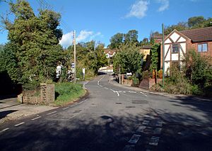
 Polesteeple Hill, Biggin Hill |
|
| Population | 10,817 |
| OS grid reference | TQ418590 |
| • Charing Cross | 15.2 mi (24.5 km) NNW |
| London borough | |
| Ceremonial county | Greater London |
| Region | |
| Country | England |
| Sovereign state | United Kingdom |
| Post town | WESTERHAM |
| Postcode district | TN16 |
| Dialling code | 01959 |
| Police | Metropolitan |
| Fire | London |
| Ambulance | London |
| EU Parliament | London |
| UK Parliament |
|
| London Assembly |
|
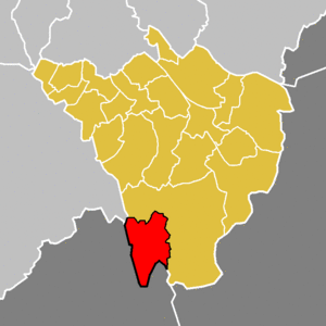
Biggin Hill is a town located in South East London, England. It's part of the London Borough of Bromley. The town is about 15.2 miles (24.5 km) south-southeast of Charing Cross, which is often seen as the center of London. Biggin Hill is right next to the border of Greater London with the counties of Kent and Surrey. Before 1965, when Greater London was created, Biggin Hill was part of Kent. In 2011, about 9,951 people lived there.
Biggin Hill is one of the highest places in Greater London, reaching over 210 metres (690 ft) (about 689 feet) above sea level. The airport in Biggin Hill uses land that was once RAF Biggin Hill. This was a very important air base during the Battle of Britain, helping to protect London from German bombers.
Contents
History of Biggin Hill
What's in a Name?
Long ago, the area we now call Biggin Hill was known by a different name: Aperfield.
Important Buildings in Biggin Hill
The most interesting building in Biggin Hill, from an architectural point of view, is St Mark's Church on Church Road. It's sometimes called 'the moving church'. This church was built in the 1950s using parts from another church, All Saints Church in North Peckham, which had been taken apart. Many volunteers helped build it, and Reverend Vivian Symons did a lot of the decorating himself.
Biggin Hill Airport
Biggin Hill has a special airport called London Biggin Hill Airport. It's more than just a place for planes to land; it has a terminal building and customs services. Much of the airport sits on land that used to be RAF Biggin Hill. This was a famous air base during the Battle of Britain in World War II. During the war, it was also the control center for defending against V-1 flying bombs, which were a type of German missile.
The old "west camp" part of the airport is now owned by Bernie Ecclestone. Many of the buildings in this area are considered historically important, known as Grade II listed buildings. A small part of the airport is still looked after by the RAF. The historic chapel there, which is also a Grade II listed building, is open to visitors. It's guarded by models of famous World War II planes: a Hawker Hurricane and a Supermarine Spitfire.
Some people say that ghosts are often seen at the old World War II air base.
The old "south camp" is now home to the Biggin Hill Business Park, an industrial estate, and several private flying clubs. There are also more businesses, airplane hangars, and a helicopter ride and pilot training center to the east of the main runway.
The airport handles many private and business jets. These can be as large as a Boeing 737. The airport has been made bigger and better in the 21st century, and there were plans for even more growth around 2020.
A special area for model aircraft also operates within the airport's air traffic zone. These are large model planes. In 2009, some model aircraft were seen, and one report was made about a plane getting too close to another aircraft.
Biggin Hill is also home to a special navigation beacon called "BIG." This beacon helps guide planes flying into London Heathrow Airport.
The airport used to host the Biggin Hill International Air Fair. This was an annual airshow that usually happened in late June. The first airshow was in 1963, but it was stopped permanently in 2010 after 48 events.
Schools in Biggin Hill
Biggin Hill has several schools. Charles Darwin School is a secondary school located within three miles of the town center.
There are two main primary schools in the area: Oaklands Primary School and Biggin Hill Primary School. Just outside of Biggin Hill, you can find Cudham CoE Primary School, Tatsfield Primary in Tatsfield, and Downe Primary in Downe village.
People and Population
The area of Biggin Hill is represented by the Biggin Hill ward. In 2011, this ward had a population of 9,951 people. This means there were about 12 people living in each hectare of land. The census also showed that 93% of the people living there were White British. The average age of the people was 42. The most common type of home was a detached house or a bungalow.
Where is Biggin Hill?
 |
New Addington | Leaves Green | Downe |  |
| Biggin Hill Valley | Berry's Green & Cudham | |||
| Tatsfield | Tatsfield East | Aperfield |
Biggin Hill is on the edge of the London Borough of Bromley. The A233 road is the only main road that goes through the area, running from north to south. Most of the places around Biggin Hill are smaller towns and villages. Biggin Hill's postcode is TN16, and its post town is Westerham, even though Westerham itself is outside Greater London.
Getting Around Biggin Hill
Biggin Hill is part of the Transport for London area. This means it has several London Buses services. There is also one bus route run by Southdown PSV. These buses connect Biggin Hill to places like Bromley, Keston, Hayes, Bromley, Westerham, Downham, Catford, Oxted, Locksbottom, New Addington, Tatsfield, Orpington and Green Street Green.
The closest train stations for national rail services are Hayes station (about 5 miles away), Oxted station in Surrey, and Bromley South station and Orpington station. The nearest Tramlink stop, which is for trams, is New Addington, about 4 miles away.
Images for kids
See also
 In Spanish: Biggin Hill para niños
 | Delilah Pierce |
 | Gordon Parks |
 | Augusta Savage |
 | Charles Ethan Porter |


