Boone County, Arkansas facts for kids
Quick facts for kids
Boone County
|
|||
---|---|---|---|
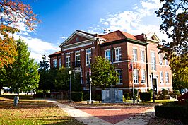
Clockwise from top: Boone County Courthouse in Harrison, Buffalo National River, Lake Harrison Park, Overlook from Gaither Mountain in the Ozarks, Harrison Courthouse Square
|
|||
|
|||
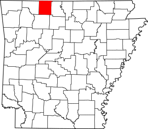
Location within the U.S. state of Arkansas
|
|||
Arkansas's location within the U.S. |
|||
Country | United States | ||
State | Arkansas | ||
Founded | April 9, 1869 | ||
Seat | Harrison | ||
Largest city | Harrison | ||
Area | |||
• Total | 602 sq mi (1,560 km2) | ||
• Land | 590 sq mi (1,500 km2) | ||
• Water | 12 sq mi (30 km2) 1.9% | ||
Population
(2020)
|
|||
• Total | 37,373 | ||
• Density | 62.08/sq mi (23.970/km2) | ||
Time zone | UTC−6 (Central) | ||
• Summer (DST) | UTC−5 (CDT) | ||
Congressional district | 1st |
Boone County is a county located in the U.S. state of Arkansas, along the Missouri border. As of the 2020 census, the population was 37,373. The county seat is Harrison. It is Arkansas's 62nd county, formed on April 9, 1869.
Boone County is part of the Harrison, AR Micropolitan Statistical Area.
Contents
History
Boone County was formed from the eastern portion of Carroll County. Contrary to popular belief, it was not named for frontiersman Daniel Boone. It was originally called Boon, since the residents believed it would be a "boon" to all who settled there. The county's first newspaper, begun in 1870, was the Boon County Advocate. However, when Governor Powell Clayton signed the act, creating the county 1869 it was titled An Act to Organize and Establish the County of Boone and for Other Purposes. So for whatever reason an "'e'" was added. In 1905 and 1909, race riots were conducted to drive African-Americans out of the area. It was marketed as an all-white sundown town into the 1920s. Today, it is known as a center of white supremacist activity, including the national headquarters of the Knights of the Ku Klux Klan in Zinc. In 2017, Boone County Judge Robert Hathaway signed proclamations recognizing June as Confederate Heritage and History Month, and issued a similar proclamation for April 2019.
Geography
According to the U.S. Census Bureau, the county has a total area of 602 square miles (1,560 km2), of which 590 sq mi (1,500 km2) is land and 12 sq mi (31 km2) (1.9%) is water. The county is located in the northwest portion of the state, and borders Missouri to the north.
The county lies entirely within the Ozark Mountains. Rolling hills of the Springfield and Salem Plateaus characterize the majority of the topography, with the more rugged Boston Mountains lying just to the south. Isolated peaks of the Boston Mountain range are found in the south, including Boat Mountain, Pilot's Knob, and Gaither Mountain. Portions of Bull Shoals Lake and Table Rock Lake lie in the northeast and northwest corners, respectively. The Corps of Engineers operates and maintains popular campsites on the lakes at Lead Hill and Cricket Creek. Crooked Creek, popular with bass fishermen, winds through the county from south to east.
Major highways
- US 62
- US 412
- U.S. Route 65
- U.S. Route 65B
- Highway 7
- Highway 14
- Highway 43
- Highway 123
- Highway 206
- Highway 281
- Highway 392
- Highway 396
- Highway 397
- Highway 980
Adjacent counties
- Taney County, Missouri (north)
- Marion County (east)
- Searcy County (southeast)
- Newton County (south)
- Carroll County (west)
Demographics
Historical population | |||
---|---|---|---|
Census | Pop. | %± | |
1870 | 7,032 | — | |
1880 | 12,146 | 72.7% | |
1890 | 15,816 | 30.2% | |
1900 | 16,396 | 3.7% | |
1910 | 14,318 | −12.7% | |
1920 | 16,098 | 12.4% | |
1930 | 14,937 | −7.2% | |
1940 | 15,860 | 6.2% | |
1950 | 16,260 | 2.5% | |
1960 | 16,116 | −0.9% | |
1970 | 19,073 | 18.3% | |
1980 | 26,067 | 36.7% | |
1990 | 28,297 | 8.6% | |
2000 | 33,948 | 20.0% | |
2010 | 36,903 | 8.7% | |
2020 | 37,373 | 1.3% | |
2023 (est.) | 38,530 | 4.4% | |
U.S. Decennial Census 1790–1960 1900–1990 1990–2000 2010–2020 |
2020 census
Race | Number | Percentage |
---|---|---|
White (non-Hispanic) | 33,753 | 90.31% |
Black or African American (non-Hispanic) | 96 | 0.26% |
Native American | 265 | 0.71% |
Asian | 233 | 0.62% |
Pacific Islander | 82 | 0.22% |
Other/Mixed | 2,026 | 5.42% |
Hispanic or Latino | 973 | 2.6% |
As of the 2020 census , there were 37,373 people, 15,034 households, and 10,455 families residing in the county. The population density was 62 inhabitants per square mile (24/km2). There were 17,368 housing units at an average density of 29 per square mile (11/km2). The racial makeup of the county was 91.32% White, 0.29% Black or African American, 0.74% Native American, 0.66% Asian, 0.07% Pacific Islander, 0.69% from other races, and 6.23% from two or more races. 2.60% of the population were Hispanic or Latino of any race.
There were 15,455 households, out of which 27.9% had children under the age of 18 living with them, 50.5% were married couples living together, 26.3% had a female householder with no spouse or partner present, 17.7% had a male household with no spouse or partner present, and 5.4% were cohabitating couples. 28.9% of all households were made up of individuals, and 14.1% were 65 years of age or older living alone. The average household size was 2.42.
Of all individuals living in the county, 22.2% under the age of 18 and 21.7% were age 65 or older. The median age was 43 years. For every 100 females, there were 96.02 males. For every 100 females age 18 and over, there were 93.02 males.
Education
Public school districts
- Alpena
- Bergman
- Harrison
- Lead Hill
- Omaha
- Valley Springs
Higher education
- North Arkansas College
Communities
Cities
- Diamond City
- Harrison (county seat)
Towns
- Alpena (portions are also in Carroll County)
- Bellefonte
- Bergman
- Everton
- Lead Hill
- Omaha
- South Lead Hill
- Valley Springs
- Zinc
Unincorporated communities
- Batavia
- Bear Creek Springs
- Capps
- Hopewell
- Little Arkansaw
- Self
Historic communities
- Elixir was a town in the vicinity of many springs. It was nearby present day Bergman. Heavy rains flooded the town in 1883, which was a major factor in its decline by 1892. In the 1880s, both Lead Hill and Elixir were expecting a railroad but none materialized. This also helped the town's decline. Although the town is gone, the township of Elixir remains and currently contains Bergman.
- Keener was a town around one mile south of present-day Bergman. Keener was strong in the 1880s and had a population of about 1,000 people. But, Keener began to decline fast by 1892.
Townships
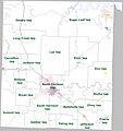
Townships in Arkansas are the divisions of a county. Each township includes unincorporated areas; some may have incorporated cities or towns within part of their boundaries. Arkansas townships have limited purposes in modern times. However, the United States Census does list Arkansas population based on townships (sometimes referred to as "county subdivisions" or "minor civil divisions"). Townships are also of value for historical purposes in terms of genealogical research. Each town or city is within one or more townships in an Arkansas county based on census maps and publications. The townships of Boone County are listed below; listed in parentheses are the cities, towns, and/or census-designated places that are fully or partially inside the township.
Former townships include Bear Creek, Crooked Creek, Elmwood, Harrison, Washington, and Young.
Township | FIPS code | ANSI code (GNIS ID) |
Population center(s) |
Pop. (2010) |
Pop. density (/mi2) |
Pop. density (/km2) |
Land area (mi2) |
Land area (km2) |
Water area (mi2) |
Water area (km2) |
Geographic coordinates |
---|---|---|---|---|---|---|---|---|---|---|---|
Batavia | 05-90144 | 00069604 | 911 | 85.48 | 33 | 10.658 | 27.60 | 0.027 | 0.06993 | 36°15′39″N 93°14′07″W / 36.260817°N 93.235402°W | |
Bellefonte | 05-90219 | 00069605 | Bellefonte, Harrison | 2380 | 93.94 | 36.27 | 25.334 | 65.61 | 0.047 | 0.1217 | 36°12′09″N 93°01′57″W / 36.202472°N 93.032619°W |
Blythe | 05-90375 | 00069606 | 245 | 20.76 | 8.01 | 11.803 | 30.57 | 0.054 | 0.1399 | 36°13′00″N 92°56′33″W / 36.216733°N 92.942489°W | |
Bryan | 05-90507 | 00069607 | Harrison | 1018 | 57.03 | 22.02 | 17.621 | 45.64 | 0.018 | 0.04662 | 36°12′21″N 93°12′17″W / 36.205811°N 93.204652°W |
Carrollton | 05-90678 | 00069608 | Alpena | 843 | 32.5 | 12.55 | 25.935 | 67.17 | 0.214 | 0.5543 | 36°18′01″N 93°16′23″W / 36.300254°N 93.273003°W |
Elixir | 05-91224 | 00069609 | Bergman | 2802 | 53.88 | 20.80 | 52.002 | 134.7 | 0.051 | 0.1321 | 36°19′06″N 93°00′29″W / 36.318389°N 93.008130°W |
Ewing | 05-91260 | 00069610 | 458 | 37.55 | 14.50 | 12.196 | 31.59 | 0.006 | 0.01554 | 36°08′15″N 93°03′12″W / 36.137467°N 93.053462°W | |
Gaither | 05-91404 | 00069611 | 676 | 32.20 | 12.43 | 20.991 | 54.37 | 0.014 | 0.03626 | 36°08′53″N 93°09′28″W / 36.147993°N 93.157690°W | |
Jackson | 05-91848 | 00069612 | Harrison | 1340 | 61.64 | 23.80 | 21.739 | 56.30 | 0.006 | 0.01554 | 36°18′19″N 93°11′24″W / 36.305402°N 93.190094°W |
Jefferson | 05-91914 | 00069613 | Valley Springs | 1202 | 77.16 | 29.79 | 15.579 | 40.35 | 0.002 | 0.005180 | 36°08′36″N 92°58′11″W / 36.143199°N 92.969805°W |
Lee | 05-92133 | 00069614 | 1867 | 40.73 | 15.73 | 45.837 | 118.7 | 0.004 | 0.01036 | 36°19′36″N 93°06′21″W / 36.326795°N 93.105766°W | |
Long Creek | 05-92268 | 00069615 | 902 | 22.75 | 8.78 | 39.655 | 102.7 | 0.071 | 0.1839 | 36°22′46″N 93°12′51″W / 36.379488°N 93.214209°W | |
North Harrison | 05-92715 | 00069616 | Harrison | 8057 | 475.82 | 183.70 | 16.933 | 43.86 | 0.055 | 0.1424 | 36°15′01″N 93°06′08″W / 36.250321°N 93.102318°W |
Olvey | 05-92757 | 00069617 | 440 | 37.27 | 14.39 | 11.807 | 30.58 | 0.013 | 0.03367 | 36°11′55″N 92°57′36″W / 36.198738°N 92.959986°W | |
Omaha | 05-92760 | 00069618 | Omaha | 2267 | 29.07 | 11.22 | 77.985 | 202.0 | 1.001 | 2.593 | 36°27′48″N 93°10′24″W / 36.463258°N 93.173287°W |
Prairie | 05-92979 | 00069619 | Everton | 444 | 27.36 | 10.54 | 16.266 | 42.13 | 0.006 | 0.01554 | 36°09′19″N 92°54′55″W / 36.155294°N 92.915207°W |
South Harrison | 05-93435 | 00069620 | Harrison | 7590 | 280.06 | 108.14 | 27.101 | 70.19 | 0.074 | 0.1917 | 36°11′26″N 93°08′04″W / 36.190474°N 93.134539°W |
Sugar Loaf | 05-93522 | 00069621 | Diamond City, Lead Hill, South Lead Hill | 2320 | 27.61 | 10.66 | 84.026 | 217.6 | 9.806 | 25.40 | 36°24′53″N 92°58′03″W / 36.414687°N 92.967603°W |
Summit | 05-93552 | 00069622 | 556 | 17.27 | 6.59 | 32.201 | 83.40 | 0.076 | 0.1968 | 36°10′12″N 93°15′03″W / 36.170125°N 93.250788°W | |
Zinc | 05-94134 | 00069623 | Zinc | 585 | 23.82 | 9.20 | 24.563 | 63.62 | 0.055 | 0.1424 | 36°16′19″N 92°55′22″W / 36.272049°N 92.922813°W |
Source: U.S. Census Bureau |
Chronic Wasting Disease
Chronic Wasting Disease has been found in Boone county, as well as Benton, Carroll, Johnson, Madison, Marion, Newton, Pope, Searcy, Sebastian, Scott, and Washington counties.
See also
In Spanish: Condado de Boone (Arkansas) para niños