
Bradford Island facts for kids

United States Geological Survey aerial imagery of Bradford Island
|
|

Bradford Island
Location in Sacramento-San Joaquin River Delta

Bradford Island
Location in San Francisco Bay Area

Bradford Island
Location in California

Bradford Island
Location in the United States
|
|
| Geography | |
|---|---|
| Location | Northern California |
| Coordinates | 38°04′38″N 121°39′48″W / 38.07722°N 121.66333°W |
| Adjacent bodies of water | Sacramento–San Joaquin River Delta |
| Area | 2,172 acres (879 ha) |
| Highest elevation | −10 ft (-3.05 m) |
| Administration | |
| State | |
| County | Contra Costa |
| Demographics | |
| Population | approx. 48 (as of 2020) |
Bradford Island is an island in California, United States. It covers about 2,172 acres. The island is part of the Sacramento–San Joaquin River Delta in Contra Costa County.
You can't drive to Bradford Island. You have to take a ferry across the False River from nearby Jersey Island. Around 48 people live on the island. People also use the land for growing wheat, raising cattle, and getting natural gas.
Bradford Island was once a wet, marshy area called a peat wetland. It has been drained and protected. Since it is lower than the sea, strong walls called levees protect it from floods. A group called Reclamation District 2059, started in 1921, manages these levees, along with pumps and canals that drain water. The levees have broken several times, causing the island to flood. Bradford Island is one of eight islands in the Delta that are very important for keeping the region's water clean.
Contents
Exploring Bradford Island's Nature
.jpg)
Bradford Island is located at 38°04′38″N 121°39′48″W / 38.07722°N 121.66333°W. It sits in the lower part of the San Joaquin River delta. The San Joaquin River separates it from Sherman Island to the west and Twitchell Island to the north. To the east, Fisherman's Cut separates it from the Webb Tract.
As mentioned, there are no bridges to the island. The only way to get there is by a ferry from Jersey Island to the south. From Bradford Island, you can see Mount Diablo to the southwest.
Land Use and Environment
Since Bradford Island was once a marsh, it has special, rich peat soil. This soil is great for growing wheat and for raising cattle. Some parts of the island are also used for homes. Because Bradford Island is above part of the Rio Vista Gas Field, there are also natural gas wells on the island.
The islands in the Sacramento–San Joaquin River Delta help stop salty ocean water from mixing with the fresh river water. Fresh water flows into the Delta from the Sacramento and San Joaquin rivers. But salty water also comes in from the Pacific Ocean through San Francisco Bay. The Delta islands slow down this salty water. Bradford Island is one of eight islands that are very important for keeping the Delta's water clean.
The island is below sea level, and its levees protect it from floods. In 1981, it was thought to be at sea level. But by 2015, it was found to be about 5 to 15 feet (1.5 to 4.6 meters) below sea level.
Wildlife and Plants
Many birds, like ducks, cranes, swans, and geese, feed in the marshes of Bradford Island. You might also see Swainson's hawks, Cooper's hawks, and red-tailed hawks flying over the island. In 2014, the Reclamation District approved a plan to remove harmful plants like Himalayan blackberry from the island.
Bradford Island's Past


In 1986, a retired minesweeper ship called the USS Lucid was brought to Bradford Island. The ship was used as a storage building. Later, in 2005, the ship was given to a Navy veteran who started to restore it. In 2011, the ship was moved to the Stockton Maritime Museum to become a museum ship.
In 2010, a large fire burned hundreds of acres on the island. It also set fire to the peat soil. At that time, Bradford Island was not part of any fire department. So, the fire was not put out quickly. It caused a lot of damage.
The number of people living on Bradford Island has changed over the years. In 2000, about 48 people lived there. In 2009, some reports said around 100 people lived on the island. Other reports from 2009 and 2010 said the population was closer to 63 or 48. By 2013, it was reported that only 13 people lived there, and in 2017, there were 8 full-time residents. A 2020 report from the Reclamation District stated the population was about 48 again.
Managing the Island: Reclamation District 2059
Reclamation District 2059 is the group that manages Bradford Island. It was started on November 21, 1921. Its main job is to take care of the levees and the water drainage systems on the island.
What the District Does
As of 2021, the District is in charge of maintaining about 7.4 miles (11.9 km) of levees around the island. They also manage one pump station and over 7 miles (11 km) of internal canals that drain water.
The District gets its money from state and federal grants, fees for the ferry service, and yearly payments from landowners. Landowners pay based on how much land they own.
The ferry, called Victory II, costs $7.50 for a round trip. But landowners and their families can get passes to ride for free. The District shares the cost of running the ferry with the nearby Webb Tract. The District has a few part-time and contract employees who help with its operations.
How the District is Run
The District follows a set of rules that were updated in May 2018. It is managed by a board of five Trustees. These Trustees are elected by the island's landowners. They serve four-year terms, and they hold regular meetings every month.
In 2008, the Board of Trustees realized they didn't have enough money for some important maintenance, like the ferry and replacing a pump station. In 2010, landowners voted to change how they paid their yearly fees. Instead of paying based on the value of their land, they started paying based on how much their land benefited from the District's services. This new way of paying was set to end in May 2015.
Protecting the Island: Levees

The Reclamation District is responsible for keeping the levees in good condition. It costs about $2,500 per mile ($1,553 per kilometer) each year to maintain them. The levees have broken and failed many times, causing the island to flood.
Past Floods and Accidents
On December 9, 1983, a storm caused a 600-foot (180 m) break in the levees. This flooded the entire island. People living there had to leave by ferry, and most did not come back.
On August 27, 2009, a large cargo ship called the Tasman Resolution hit the north side of the island. The ship was 570 feet (170 m) long. This accident damaged the levee, causing a 150-foot (46 m) section to wash away. The repairs cost $800,000. While officials planned to evacuate 100 people, only nine were found, and eight of them chose to stay.
Levee Improvements
In 2014, big improvements were made to the levee system. They added rocks, made the back slopes stronger, and raised the tops of the levees. After these improvements, most of the levees met safety standards. Only a small section along the San Joaquin River still needed work.
In July 2014, a special barrier was placed across the False River to help with drought conditions. In 2015, a "Muscle Wall" was put on the lower parts of the levees just before a very high tide.
Levee Challenges
In 2015, during a levee check, goats were seen running around on the levees. Goats can cause erosion, which means they can wear away the soil. The District does not allow goats on the levees and asked landowners to report any sightings.
In August 2018, the Reclamation District declared an emergency because water was leaking through a 25-foot (7.6 m) section of the levee. They made emergency repairs by fixing holes with steel sheets. This was a temporary fix that cost about $200,000.
Images for kids
-
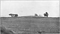
An approximately 20 ft (6.1 m) high shellmound on the western end of Bradford Island in 1909.
-
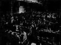
Asparagus packers at the Meek farm, 1915
-
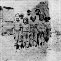
Asparagus field workers from Bradford Island in 1921
-
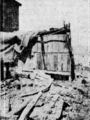
A hut where a family of four lived


.png)
