Bradley County, Arkansas facts for kids
Quick facts for kids
Bradley County
|
|
|---|---|

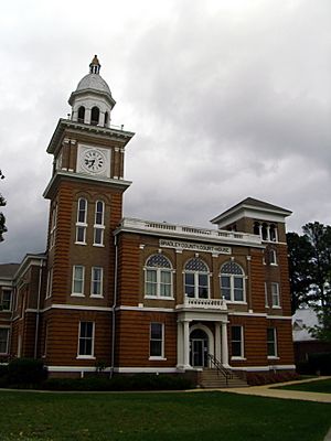
Bradley County Courthouse
|
|

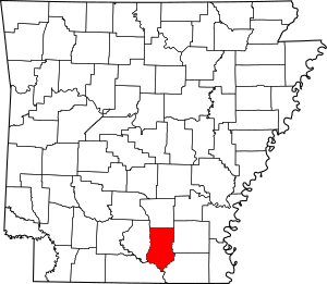
Location within the U.S. state of Arkansas
|
|
 Arkansas's location within the U.S. |
|
| Country | |
| State | |
| Founded | December 18, 1840 |
| Named for | Hugh Bradley |
| Seat | Warren |
| Largest city | Warren |
| Area | |
| • Total | 653 sq mi (1,690 km2) |
| • Land | 649 sq mi (1,680 km2) |
| • Water | 3.7 sq mi (10 km2) 0.6%% |
| Population
(2020)
|
|
| • Total | 10,545 |
| • Density | 16.149/sq mi (6.235/km2) |
| Time zone | UTC−6 (Central) |
| • Summer (DST) | UTC−5 (CDT) |
| Congressional district | 4th |
Bradley County is a county in the U.S. state of Arkansas. In 2020, about 10,545 people lived there. The main town, or county seat, is Warren.
Bradley County became Arkansas's 43rd county on December 18, 1840. It was named after Captain Hugh Bradley, who was a soldier in the War of 1812.
Bradley County is known as a dry county. This means that selling alcoholic drinks is usually not allowed. However, some towns inside the county, like Warren and Hermitage, might have their own rules that let them sell alcohol.
History
For thousands of years, different groups of Indigenous peoples lived along the rivers in Arkansas. They built amazing societies. The Mississippian culture people, for example, built huge earthwork mounds along the Ouachita River. They started doing this around the year 1000.
Caddo Tribe
The Felsenthal refuge is in the southern part of Bradley County. It has over 200 old Native American sites. Most of these sites are from the Caddo tribe. The Caddo lived in this area as far back as 5,000 years ago.
These sites show where they had seasonal fishing camps. There are also places for ceremonies, temple mounds, and large villages. Some villages had as many as 200 buildings.
European Control
After Hernando de Soto explored the Mississippi Valley in the 1540s, Europeans didn't visit the Ouachita River valley much until the late 1600s.
French and Spanish Rule
France and Spain both controlled the Louisiana area at different times. The French were the first Europeans to explore the Ouachita River valley. They were hunters, trappers, and traders.
Later, French settlers moved north from southern French Louisiana. They named many of the bayous (slow-moving streams).
Spain took control of Louisiana in the late 1760s. They wanted to create a strong buffer zone between the American states and their land. So, in 1781, Spain created the "Poste d'Ouachita." Jean-Baptist Filhiol was put in charge. He helped Spain keep control of the area until 1804.
The Louisiana Purchase
In 1800, Napoleon Bonaparte secretly gave Louisiana back to France from Spain. But it stayed under Spanish control for a few more years.
The Louisiana Purchase happened in 1803. The United States bought a huge amount of land from France. This land was France's claim to the Louisiana territory. It was about 828,800 square miles (2,146,400 square kilometers). This purchase greatly expanded the size of the United States.
Name Origins
Many places in Bradley County have names that tell a story:
- L'Aigles Creek: Means "Eagle Creek" in French.
- Felsenthal: A German word meaning "hills and valleys" or "rocky valleys."
- Moreau Bayou: Moreau is a common French surname.
Early American Settlers
Between 1837 and 1861, many settlers came to Bradley County. They came from states like Mississippi, Alabama, Tennessee, and Georgia. These settlers often traveled up the Ouachita River to reach the good farmland.
Geography
Bradley County covers a total area of 653 square miles (1,690 square kilometers). Most of this is land, about 649 square miles (1,680 square kilometers). Only a small part, about 3.7 square miles (9.6 square kilometers), is water.
The Mississippi Embayment reaches the Saline River valley in the east and southeast of the county. The Ouachita River flows along the southwest edge. The Saline River runs along most of the east side. The L'Aigle Creek drains most of the county's area.
Major Highways
Neighboring Counties
Bradley County shares borders with these counties:
- Cleveland County (north)
- Drew County (east)
- Ashley County (southeast)
- Union County (southwest)
- Calhoun County (west)
Protected Area
Part of the Felsenthal National Wildlife Refuge is located in Bradley County. This refuge protects wildlife and their habitats.
People of Bradley County
| Historical population | |||
|---|---|---|---|
| Census | Pop. | %± | |
| 1850 | 3,829 | — | |
| 1860 | 8,388 | 119.1% | |
| 1870 | 8,646 | 3.1% | |
| 1880 | 6,285 | −27.3% | |
| 1890 | 7,972 | 26.8% | |
| 1900 | 9,651 | 21.1% | |
| 1910 | 14,518 | 50.4% | |
| 1920 | 15,970 | 10.0% | |
| 1930 | 17,494 | 9.5% | |
| 1940 | 18,097 | 3.4% | |
| 1950 | 15,987 | −11.7% | |
| 1960 | 14,029 | −12.2% | |
| 1970 | 12,778 | −8.9% | |
| 1980 | 13,803 | 8.0% | |
| 1990 | 11,793 | −14.6% | |
| 2000 | 12,600 | 6.8% | |
| 2010 | 11,508 | −8.7% | |
| 2020 | 10,545 | −8.4% | |
| 2023 (est.) | 10,104 | −12.2% | |
| U.S. Decennial Census 1790–1960 1900–1990 1990–2000 2010–2016 |
|||
2020 Census Information
In 2020, the 2020 United States census counted 10,545 people living in Bradley County. There were 4,419 households and 2,827 families.
The population was made up of different groups:
- About 54% were White (not Hispanic).
- About 28% were Black or African American (not Hispanic).
- About 15% were Hispanic or Latino (of any race).
- Smaller groups included Native American, Asian, and people of two or more races.
Communities
Cities
Town
Unincorporated Communities
These are smaller places that are not officially cities or towns:
Townships
Townships in Arkansas are the divisions of a county. Each township includes unincorporated areas; some may have incorporated cities or towns within part of their boundaries. Arkansas townships have limited purposes in modern times. However, the United States Census does list Arkansas population based on townships (sometimes referred to as "county subdivisions" or "minor civil divisions"). Townships are also of value for historical purposes in terms of genealogical research. Each town or city is within one or more townships in an Arkansas county based on census maps and publications. The townships of Bradley County are listed below; listed in parentheses are the cities, towns, and/or census-designated places that are fully or partially inside the township. Townships are smaller areas within a county. Bradley County has several:
- Clay (Banks)
- Eagle
- Marion
- Moro
- Ouachita
- Palestine
- Pennington (Warren)
- River
- Sumpter
- Washington (Hermitage)
Piney Woods
Bradley County is part of the Arkansas Timberlands region. This area is also known as the Piney Woods, because it has many pine forests.
See also

- In Spanish: Condado de Bradley (Arkansas) para niños
 | Valerie Thomas |
 | Frederick McKinley Jones |
 | George Edward Alcorn Jr. |
 | Thomas Mensah |


