
Bridgton, Maine facts for kids
Quick facts for kids
Bridgton, Maine
|
|
|---|---|

Bird's eye view of 1888 Bridgton
|
|

Location in Cumberland County and the state of Maine.
|
|
| Country | United States |
| State | Maine |
| County | Cumberland |
| Incorporated | 1794 |
| Villages | Bridgton North Bridgton South Bridgton West Bridgton Sandy Creek |
| Area | |
| • Total | 64.24 sq mi (166.38 km2) |
| • Land | 56.79 sq mi (147.09 km2) |
| • Water | 7.45 sq mi (19.30 km2) |
| Elevation | 400 ft (100 m) |
| Population
(2020)
|
|
| • Total | 5,418 |
| • Density | 95/sq mi (36.8/km2) |
| Time zone | UTC-5 (Eastern (EST)) |
| • Summer (DST) | UTC-4 (EDT) |
| ZIP Codes |
04009 (Bridgton)
04057 (North Bridgton) |
| Area code(s) | 207 |
Bridgton is a town in Cumberland County, Maine, United States. About 5,418 people lived there in 2020. It's a popular place for vacations in Maine's Lakes Region. Bridgton is home to Bridgton Academy, a special school, and a fun event called the Four on the Fourth Road Race. The town is also part of the larger Portland area.
Contents
History of Bridgton
Long ago, this area was called Pondicherry. In 1768, a group led by Moody Bridges got the land. People started settling here in 1770 in what is now North Bridgton. They even built a tavern.
The community became Bridgetown Plantation in 1779, named after Moody Bridges. Later, on February 7, 1794, it officially became the town of Bridgton.
How Water Power Helped Bridgton Grow
Stevens Brook is a small stream, but it was very important. It provided water power for 12 different mills. This helped Bridgton become an industrial center. There were sawmills, gristmills, and mills that made woolen fabric. Other factories made leather, shoes, and bricks.
Later, a plant was built to pack corn and vegetables. There was also a metal factory, a machine shop, and even a shop that made coffins.
Transportation and Tourism
The town grew even more when the Cumberland and Oxford Canal opened in 1832. This canal allowed goods made in Bridgton to be sent to Portland. By the mid-1800s, about 3,000 people lived in the town.
When the main railway bypassed Bridgton, the town built its own smaller railway. This was the Bridgton and Saco River Railroad, which connected to the bigger rail network in 1883.
Summer visitors started arriving by train and steamboat. After 1919, more tourists came by car when the Theodore Roosevelt International Highway was created. This road is now U.S. Route 302. Because of cars, the canal steamboats stopped in 1932, and the narrow-gauge railroad closed in 1941.
Today, Bridgton is still a popular place for vacations. Many children's summer camps are located along the beautiful lakes. Pleasant Mountain Ski Area (once called Shawnee Peak) is a ski resort in the western part of town.
Villages and Neighborhoods in Bridgton
Bridgton has several smaller areas, or neighborhoods, within the town.
- Bridgton is the main downtown area. It's located on Route 302, near Highland Lake. This area has shops, offices, and a movie theater. You'll also find Stevens Brook Elementary School and Pondicherry Park here. Pondicherry Park is a large natural area with forests and trails.
- North Bridgton is located near the towns of Waterford and Harrison. The main feature here is Bridgton Academy. This area offers amazing views of Long Lake.
- South Bridgton is to the south of the main town. It's mostly off Route 107, near Sebago. The South Bridgton Congregational Church is a central spot in this area.
- Sandy Creek is a smaller part of South Bridgton. It's located around Denmark Road, close to Woods Pond Beach. This area has many summer camps and is mostly homes.
- West Bridgton is next to Denmark and Fryeburg. The main part of this area is on Route 302, stretching from the West Bridgton Fire Station to Shawnee Peak. Moose Pond is also here, and Camp Winona has been operating in West Bridgton for over 100 years.
Geography of Bridgton
Bridgton covers about 64 square miles (166 square kilometers). Most of this is land, but about 7.45 square miles (19.30 square kilometers) is water.
Lakes and Streams
To the east of Bridgton is Long Lake. This lake eventually flows into Sebago Lake and then into the Atlantic Ocean. Long Lake gets some of its water from Stevens Brook. Stevens Brook starts at Highland Lake, which is just west of downtown Bridgton.
In West Bridgton, part of Pleasant Mountain rises, which includes the Shawnee Peak Ski Area. At the bottom of Pleasant Mountain is Moose Pond. This is a man-made lake that touches parts of Bridgton, Denmark, and Sweden. Moose Pond eventually drains into the Saco River.
Highland Lake
| Highland Lake | |
|---|---|

Highland Lake
Location in Maine
|
|
| Coordinates | 44°05′N 70°44′W / 44.083°N 70.733°W |
| Primary outflows | Stevens Brook |
| Basin countries | United States |
| Max. length | 4 mi (6.4 km) |
| Surface area | 1,334 acres (540 ha) |
| Max. depth | 44 feet (13 m) |
| Water volume | 24,904 acre⋅ft (30,719,000 m3) |
| Surface elevation | 423 ft (129 m) |
Highland Lake stretches north from downtown Bridgton to the border with Sweden. Water flows into the north end of the lake from other ponds. The south end of the lake flows into Stevens Brook, which helped power early mills in Bridgton. Many homes and cabins are built along the lake's shore. You can launch boats at a town ramp at the south end of the lake.
Climate in Bridgton
Bridgton has a climate with big changes in temperature throughout the year. Summers are warm to hot and often humid. Winters are cold, sometimes very cold. This type of climate is called a humid continental climate. The highest temperature ever recorded in Maine was 105 degrees Fahrenheit, and it happened in North Bridgton.
Population of Bridgton
| Historical population | |||
|---|---|---|---|
| Census | Pop. | %± | |
| 1790 | 329 | — | |
| 1800 | 646 | 96.4% | |
| 1810 | 882 | 36.5% | |
| 1820 | 1,160 | 31.5% | |
| 1830 | 1,541 | 32.8% | |
| 1840 | 1,987 | 28.9% | |
| 1850 | 2,710 | 36.4% | |
| 1860 | 2,556 | −5.7% | |
| 1870 | 2,685 | 5.0% | |
| 1880 | 2,863 | 6.6% | |
| 1890 | 2,605 | −9.0% | |
| 1900 | 2,868 | 10.1% | |
| 1910 | 2,660 | −7.3% | |
| 1920 | 2,546 | −4.3% | |
| 1930 | 2,659 | 4.4% | |
| 1940 | 3,035 | 14.1% | |
| 1950 | 2,950 | −2.8% | |
| 1960 | 2,707 | −8.2% | |
| 1970 | 2,967 | 9.6% | |
| 1980 | 3,528 | 18.9% | |
| 1990 | 4,307 | 22.1% | |
| 2000 | 4,883 | 13.4% | |
| 2010 | 5,210 | 6.7% | |
| 2020 | 5,418 | 4.0% | |
| U.S. Decennial Census | |||
In 2010, about 5,210 people lived in Bridgton. There were 2,240 households, and 1,431 families. The town had about 91.7 people per square mile. Most of the people (96.6%) were White.
About 24.5% of households had children under 18. Many households (48.7%) were married couples living together. The average age in Bridgton was 46.8 years old.
Interesting Places to Visit in Bridgton
- Benjamin Cleaves House
- Dalton Holmes Davis Memorial Library
- Lt. Robert Andrews House
- Narramissic (Peabody-Fitch Farm) & Bridgton Historical Society Museum
- Rufus Porter Museum
- Shawnee Peak Ski Area
- South Bridgton Congregational Church
- Spratt-Mead Museum
- Stone House
- Wales and Hamblen Store
- Walker Memorial Hall
- William F. Perry House
- Bridgton Hospital
- Pondicherry Park
Famous People from Bridgton
- William Pitt Fessenden, who worked for President Abraham Lincoln
- John Ripley Freeman, an engineer
- Olive Fremstad, an opera singer
- Marsden Hartley, an artist
- Ian Harvie, a comedian and actor
- Stephen King, a famous author
- George D. Libby, a soldier
- Nathaniel Littlefield, a congressman
- Lois Lowry, an author
- Jim Mains, a baseball player
- Willard Mains, a baseball player
- Luther F. McKinney, a minister and congressman
- David Nolan, an author and historian
- Rufus Porter, an artist and founder of Scientific American magazine
- Karl L. Rankin, an ambassador
- William P. Rounds, a politician
- Seba Smith, an author
- Sarah Katherine Taylor, an evangelist and newspaper editor
Images for kids
-
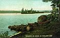
Highland Lake in 1908
-
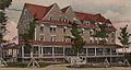
Bridgton House in 1906
-
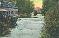
Dam and falls around 1910


See also
 In Spanish: Bridgton (Maine) para niños
