Bromborough facts for kids
Quick facts for kids Bromborough |
|
|---|---|
| Town | |
 Bromborough Cross |
|
| Population | 14,850 (2011 census) |
| OS grid reference | SJ349825 |
| • London | 175 mi (282 km) SE |
| Metropolitan borough | |
| Metropolitan county | |
| Region | |
| Country | England |
| Sovereign state | United Kingdom |
| Post town | WIRRAL |
| Postcode district | CH62 and CH63 |
| Dialling code | 0151 |
| ISO 3166 code | GB-WRL |
| Police | Merseyside |
| Fire | Merseyside |
| Ambulance | North West |
| EU Parliament | North West England |
| UK Parliament |
|
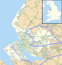
Bromborough is a town located in Merseyside, England. It's found on the Wirral Peninsula, a piece of land that sticks out into the sea. Bromborough is southeast of Bebington and north of Eastham. In 2011, about 14,850 people lived here.
Contents
Bromborough's Past: A Look at History
The name Bromborough might come from an old English word, Brunanburh. This means "Bruna's fortification" or "Bruna's fort." Some historians think Bromborough was the site of a huge battle in 937. This battle, called the Battle of Brunanburh, helped make England a single, united kingdom.
However, not everyone agrees. Some experts suggest the name means "the brown fort." This would refer to a stone-built fort. An old Anglo-Saxon cross, put back together from pieces, stands in the churchyard of St Barnabas. Bromborough isn't mentioned in the very old Domesday Survey. Its name first appears in records around the 1100s.
Bromborough's Old Market and Mills
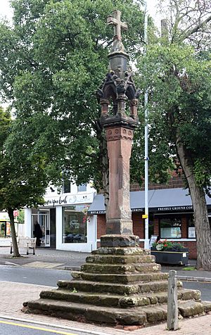
In 1278, King Edward I gave permission for Bromborough to hold a market every Monday. This market was for the monks of St. Werburgh's Abbey. The market cross was the heart of the village. It was also a meeting spot for farm workers looking for jobs. The bottom steps of the cross are from the original 13th-century monument. The top part of the cross is newer, given to the town by the Bromborough Society.
Bromborough also had an old watermill on the River Dibbin. It was likely the oldest mill on the Wirral. This mill worked until 1940 and was taken down in 1949. Today, a children's nursery is on that spot. There was also a windmill built in 1777 on higher ground nearby. It stopped being used and was destroyed around 1878.
In the 1930s, Bromborough changed a lot. More cars and people were passing through. Bromborough Hall, built in 1617, was taken down in 1932. This made way for a new road. Many old farmhouses and cottages near Bromborough Cross were replaced with shops.
How Bromborough's Government Changed
Bromborough was once a small area called a township and parish. In 1866, it became a civil parish. From 1894, it was also an urban district. These local government areas were removed on April 1, 1922. Bromborough then joined with nearby areas to form Bebington cum Bromborough. In 1921, about 2,652 people lived in the parish. Later, in 1974, Bromborough moved from Cheshire county to the new county of Merseyside.
Bromborough's Location and Surroundings
Bromborough is on the eastern side of the Wirral Peninsula. It sits next to the western side of the River Mersey. The town is about 12.5 km (7.8 mi) south-southeast of the Irish Sea. It's also about 8 km (5.0 mi) east-northeast of the Dee Estuary. Bromborough Cross, in the town center, is about 32 m (105 ft) above sea level.
 |
Bebington | Spital Dibbinsdale |
Aigburth (across River Mersey) |
 |
| Clatterbridge Raby Mere |
Speke (across River Mersey) |
|||
| Willaston | Eastham | Eastham |
Bromborough's Government and Local Leaders
Bromborough is part of the Wirral South area for national elections. The current Member of Parliament (MP) for this area is Alison McGovern. She is a member of the Labour party.
For local government, Bromborough is a ward within the Metropolitan Borough of Wirral. This means it has its own local councillors. As of 2024, the ward's borders are generally Stanley Road to the north and Acre Lane to the south. The River Mersey is to the east, and the railway line is to the west. Bromborough has three councillors who represent the town on the Wirral Council. The most recent local elections were on May 2, 2019.
Important Places in Bromborough: Landmarks
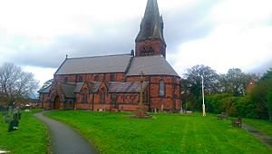
The Bromborough Cross, in the old part of the village, is a very important historical site. It is a Grade II* listed building, meaning it's protected. St Barnabas' Church was designed by George Gilbert Scott. It was built in the 1860s to replace an older, smaller church. This church is also a Grade II* listed building.
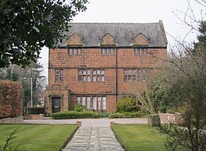
Other old buildings still standing include Stanhope House and Pear Tree Cottage. These are Grade II listed buildings. They are from the late 1600s.
Life in Bromborough: Community and Green Spaces
West of the A41 New Chester Road, Bromborough is mostly homes. These homes started being built in the 1930s. The area is centered around the old village with its market cross.
Bromborough has several pubs. These include 'The Bromborough,' the 'Royal Oak,' and the Bromborough Social Club. 'The Archers' pub closed down by 2013. On the edge of town, near Eastham, are 'The Merebrook' and 'The Dibbinsdale'. You can also find a Pesto restaurant there.
For outdoor fun, Bromborough has green spaces. These include Brotherton Park and Dibbinsdale Local Nature Reserve, which is along the River Dibbin. There's also Marfords Park to the southwest of town. Local news can be found in the Bromborough and Bebington News and the Wirral Globe newspapers.
Bromborough's Work and Businesses: Economy
East of the A41 road, closer to the River Mersey, you'll find industrial areas. This includes Bromborough Pool, an early "model village" built between 1853 and 1858 by Price's Candles. Some of the businesses here are connected to the old Bromborough Dock. There's a warehouse for fertilizer and the main landfill site for the Wirral. This landfill is now a walking path with river views.
Cereal Partners has a factory here. They employ 340 people and make breakfast cereals like Cheerios and Corn Flakes. This factory used to be owned by Viota. Another big business is Sun Valley Snacks Ltd, which processes peanuts. The Croft Retail & Leisure Park opened in March 1990. It's a shopping and entertainment area located off the A41.
Getting Around Bromborough: Transport
Roads in Bromborough
The main road through Bromborough is the A41 New Chester Road. The B5137 Spital Road also joins the A41 in Bromborough. Two exits of the M53 motorway are about 3 km (1.9 mi) from Bromborough. Junction 4 is to the west, and Junction 5 is to the south.
Bus Services
Many local bus services serve Bromborough. Most are run by Stagecoach Merseyside. The Stagecoach Gold service 1 offers direct, comfortable trips. You can go north to Liverpool and Birkenhead. Or you can go south to Chester, Chester Zoo, and Ellesmere Port.
Train Travel
Bromborough and Bromborough Rake train stations are both on the Wirral line of the Merseyrail network. Trains run every 15 minutes to Chester. They run every 30 minutes to Ellesmere Port. There are also six trains per hour to Liverpool Central.
 | Jessica Watkins |
 | Robert Henry Lawrence Jr. |
 | Mae Jemison |
 | Sian Proctor |
 | Guion Bluford |


