
California Historical Landmarks in San Mateo County facts for kids
California is full of amazing historical places, and San Mateo County has many of them! These special spots are called California Historical Landmarks. They are important because they help us remember cool stories and events from the past.
Imagine exploring places where famous explorers camped, where important buildings stood, or where big events happened. That's what these landmarks are all about! They teach us about the people and moments that shaped California.
Historic Places in San Mateo County
Let's take a look at some of the interesting California Historical Landmarks you can find in San Mateo County.
Early Explorers and Camps
Many landmarks in San Mateo County are linked to early explorers, especially the Portolá Expedition. This group was the first European land expedition to explore California in 1769.
Anza Expedition Camps
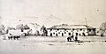
- Anza Expedition Camp (San Mateo) (CHL 47): This camp was located on the banks of San Mateo Creek in San Mateo. It was a stop for the Anza Expedition, another important Spanish exploration group.
- Anza Expedition Camp (Burlingame) (CHL 48): Another camp from the Anza Expedition was found near El Camino Real and Ralston in Burlingame.
Portolá Expedition Trail
The Portolá Expedition traveled through many parts of San Mateo County. Several landmarks mark their journey, often called the Ohlone-Portolá Heritage Trail, honoring both the explorers and the Ohlone Native Americans who lived here.
- Ohlone-Portolá Heritage Trail, Purisíma Creek (CHL 22): This spot is at the mouth of Purisíma Creek in Half Moon Bay.
- Ohlone-Portolá Heritage Trail at Gazos Creek (CHL 23): You can find this landmark at the mouth of Gazos Creek in Pescadero.
- Portolá Expedition Camp (Pacifica) (CHL 24): This camp was at the mouth of San Pedro Creek in Pacifica.
- Ohlone-Portolá Heritage Trail at Montara Mountain (CHL 25): This site is at the foot of Montara Mountain in Montara.
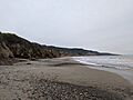
- Portolá Expedition Camp (San Gregorio) (CHL 26): Another camp was located at San Gregorio State Beach in San Gregorio.
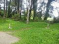
- Portolá Expedition Camp (Millbrae) (CHL 27): This camp was near San Andreas Lake in Millbrae.
- Ohlone-Portolá Heritage Trail at Cañada de Reymundo (CHL 92): This camp was near the Pulgas Water Temple in Woodside.
- Ohlone-Portolá Heritage Trail at Laguna Grande (CHL 94): This spot is north of the Pulgas Water Temple, under the Crystal Springs Reservoir in Woodside.
- Portolá Journey's End (CHL 2): This landmark marks the end of the Portolá journey in Menlo Park, near E. Creek Drive and Alma Street.
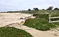
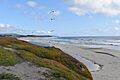
- Ohlone-Portolá Heritage Trail at Tunitas Beach (CHL 375): This site is at the mouth of Tunitas Creek at Tunitas Beach in Half Moon Bay.
- Ohlone-Portolá Heritage Trail at Año Nuevo (CHL 1058): This landmark is located at Año Nuevo State Park in Pescadero.
- Ohlone-Portolá Heritage Trail at Bean Hollow (CHL 1059): You can find this spot at Bean Hollow State Beach in Pescadero.
- Ohlone-Portolá Heritage Trail at Pilarcitos Creek (CHL 21): This landmark is near the mouth of Pilarcitos Creek at Half Moon Bay State Beach in Half Moon Bay.
San Francisco Bay Discovery Site
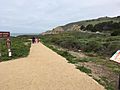
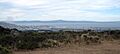
- San Francisco Bay Discovery Site (CHL 394): This important site is on Sweeney Ridge in Pacifica. It's where the Portolá expedition first saw San Francisco Bay, a huge moment in California's history. It's also on the NRHP list.
Historic Buildings and Sites
San Mateo County is also home to many historic buildings, from grand mansions to simple churches and old stores.
Famous Homes and Estates
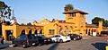
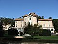
- Carolands (CHL 886): Located in Hillsborough, Carolands is a beautiful and very large mansion. It's also listed on the NRHP.
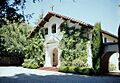
- Filoli (CHL 907): This stunning country estate is in Woodside. It features a grand house and beautiful gardens, often used for movies and TV shows.
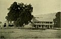
- Ralston Hall (CHL 856): Found at the College of Notre Dame in Belmont, Ralston Hall is a historic building that was once a grand home. It's also on the NRHP list.
Historic Churches
- First Congregational Church of Pescadero (CHL 949): This historic church is on San Gregorio Street in Pescadero.
- Our Lady of the Wayside Church (CHL 909): This charming church is located on Portola Road in Portola Valley.
Other Notable Buildings
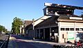
- Burlingame Station (CHL 846): This historic train station is at 290 California Drive in Burlingame. It's also on the NRHP list.
- Casa de Tableta (CHL 825): Also known as Alpine Inn, this historic spot is on Alpine Road in Portola Valley. It's also on the NRHP list.
- Menlo Park Station (CHL 955): This train station at 1120 Merrill Street in Menlo Park is another historical landmark. It's also on the NRHP list.
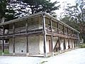
- Sánchez Adobe (CHL 391): Located in Sánchez Adobe Park in Pacifica, this adobe building has a long history. It's also on the NRHP list and part of the Ohlone-Portolá Heritage Trail.
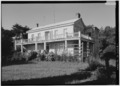
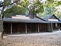
- Woodside Store (CHL 93): This old store at 471 Kings Mountain Road in Woodside tells a story of early life in the area.
Sites That No Longer Exist
Some landmarks mark places where important buildings once stood, even if they are gone now.
- Capidro (CHL 939-8): This was a unique folk art display on a home in Menlo Park that no longer exists.
- Mission Hospice (CHL 393): This site in San Mateo was once Mission San Mateo, an outpost of Mission San Francisco de Asis. The buildings were later used as an inn but are no longer standing.
- Old Store at La Honda (CHL 343): This building, once at the corner of La Honda Road and Sears Ranch Road in La Honda, no longer exists.
Other Historical Sites
- Broderick-Terry Dueling Place (CHL 19): This site at 1100 Lake Merced Boulevard in Daly City marks the location of a famous duel.
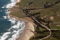
- Pigeon Point Lighthouse (CHL 930): This tall lighthouse is a well-known landmark near Davenport.
- San Mateo County's first sawmill (CHL 478): This historic site on Portola Road in Woodside marks where the first sawmill in the county was located.
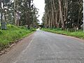
- Searsville (CHL 474): This was the site of a former village located within the Jasper Ridge Biological Preserve in Woodside.
- Steele Brothers Dairy Ranches (CHL 906): These historic dairy ranches are located within Año Nuevo State Reserve in Pescadero.
- Tanforan Assembly Center (CHL 934): This site, now the Tanforan Shopping Center in San Bruno, was once a temporary camp during World War II.
- Union Cemetery (CHL 816): This historic cemetery at El Camino Real and Woodside Road in Redwood City is also on the NRHP list.
These landmarks help us connect with the past and understand the rich history of San Mateo County!
Images for kids
-
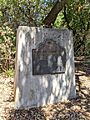
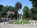
Anza Expedition Camp in San Mateo
-
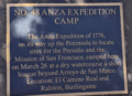
Anza Expedition Camp in Burlingame
-
Broderick-Terry Dueling Place
-
Burlingame Station
-

Carolands
-
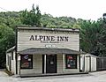
Casa de Tableta (Alpine Inn)
-
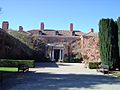
Filoli
-
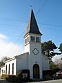
First Congregational Church of Pescadero
-
Menlo Park Station
-
Mission San Mateo (former site of Mission Hospice)
-
Our Lady of the Wayside Church
-

Pigeon Point Lighthouse
-
Ohlone-Portolá Heritage Trail, Purisíma Creek
-
Ohlone-Portolá Heritage Trail at Gazos Creek
-
Ohlone-Portolá Heritage Trail at Montara Mountain
-
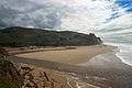
Portolá Expedition Camp at San Gregorio State Beach
-
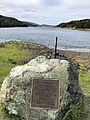
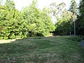
Portolá Expedition Camp at San Andreas Lake
-
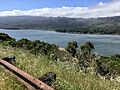
Ohlone-Portolá Heritage Trail at Laguna Grande
-
Portolá Journey's End
-
Ralston Hall
-
Sánchez Adobe
-
San Francisco Bay Discovery Site
-
Searsville
-
Steele Brothers Dairy Ranches
-
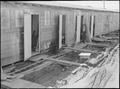
Tanforan Assembly Center
-
Ohlone-Portolá Heritage Trail at Tunitas Beach
-
Union Cemetery
-
Woodside Store
-
Ohlone-Portolá Heritage Trail at Año Nuevo
-
Ohlone-Portolá Heritage Trail at Bean Hollow
-
Ohlone-Portolá Heritage Trail at Pilarcitos Creek
.jpg)


_(14597215937).jpg)

.JPG)


