California Valley, California facts for kids
Quick facts for kids
California Valley
|
|
|---|---|
| Country | United States |
| State | California |
| County | San Luis Obispo |
| Area | |
| • Total | 37.6 sq mi (97.5 km2) |
| Elevation | 1,970 ft (600 m) |
| Population
(2020)
|
|
| • Total | 2,414 |
| • Density | 64.13/sq mi (24.759/km2) |
| Time zone | UTC-8 (Pacific (PST)) |
| • Summer (DST) | UTC-7 (PDT) |
| ZIP codes |
93453
|
| Area code(s) | 805/820 |
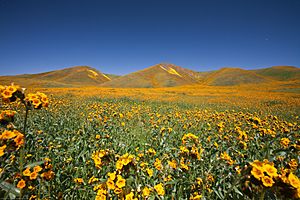
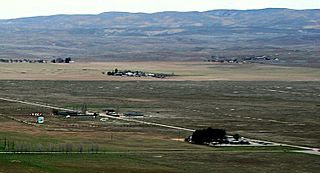
California Valley (in Spanish: Valle de California) is a small, undeveloped community. It is located in the eastern part of San Luis Obispo County, California. You can find it in the northern area of the Carrizo Plain.
Contents
Geography and Landscape
California Valley covers about 97.5 square kilometers (24,083 acres). It sits about 600 meters (1,970 feet) above sea level. The valley floor is very flat. Mountains, part of the Los Padres National Forest, border it to the west. To the east, you'll find the famous San Andreas Fault, which is part of the Temblor Range.
Just south of California Valley is Soda Lake. This lake is part of the Carrizo Plain National Monument.
Who Lives Here? (Demographics)
As of the 2020 Census, 2,414 people lived in California Valley. There were 1,206 households in total. Most residents, about 95%, were White. About 4.2% were African American, and 3.7% were Native American. Around 3.7% of people identified with two or more races. About 7.1% of the population was Hispanic or Latino.
The average household income was $50,893. About 12.3% of households lived below the poverty level.
A Look Back in Time (History)
Native Americans likely visited California Valley long ago. They probably passed through on their way to a special place called Painted Rock. However, no permanent Native American settlements were here. This was mainly because it was hard to find easy access to water.
Later, California Valley became a Spanish land grant called the El Chicote Ranch. It was used to raise cattle during certain seasons.
Local newspapers suggest that outlaws sometimes hid in California Valley until the 1930s. In 1960, land developers divided the Spanish land grant into over 7,200 small sections. Each section was about 2.5 acres (10,000 square meters). The developers hoped that the California State Water Project would bring water to the area.
However, the water project chose a different route. Many land buyers then lost interest, and many properties were left empty. The developers eventually went bankrupt. A few ranches and other places built dirt or gravel airstrips. One paved runway was even built and appeared on flight maps for a time.
Since then, a few hundred people have built homes in this quiet area. But the big growth that was once promised never happened. A Community Services District (CSD) was created to help residents. This district provides services like trash collection, road improvements, and takes care of a Community Center with a small public library.
Between 1960 and 2000, a lot of trash and old cars were dumped in the California Valley. This caused serious environmental issues. In 2006, several groups worked together to clean up the area. These included the California Highway Patrol and San Luis Obispo County Code Enforcement.
Getting Around (Infrastructure)
California Valley is located on Soda Lake Road. It's about 3 kilometers (two miles) south of State Route 58. A small general store and a restaurant that used to be popular are now closed.
The community has a school and a community center with a library. The library is open only on Wednesdays. Besides State Route 58 and Bitterwater Road, you can mostly access the area through the Carrizo Plain. This is done using Soda Lake Road. South of Soda Lake, this road is an improved dirt road that can be used seasonally. There are no regular bus routes or train lines serving the community.
Private Airport
The private California Valley Airport has a paved runway that is about 4,200 feet (1,280 meters) long. It extends south from the community center. This runway is not marked on current flight maps. It has a white "X" painted at the south end, meaning it's closed. However, it can be used if you get permission beforehand.
Community Services
The California Valley Community Service District (CSD) provides services to the community. These include road maintenance and limited trash collection. The Community Center has a fire station, a small library, and a hall for community gatherings. You can find it at 13084 Soda Lake Road.
Water, a portable toilet, and a pay phone are available at the Community Center. There has been some debate about the quality of the water. Many residents believe it is safe to drink, but signs have been posted in the past saying otherwise.
Electricity is available in some parts of California Valley. Telephone service is provided by SBC. The local phone numbers start with (805) 475-XXXX. There is good analog mobile phone coverage and some GSM mobile phone coverage. Verizon Wireless also has a tower that covers much of the valley.
The local zip code is 93453. Mail is delivered to drop boxes at the Community Center. Main roads like Belmont Trail, Soda Lake Road, and Seven Mile Road are partly paved. Other roads are made of packed dirt or decomposed granite. Only roads with homes on them are regularly maintained.
Signs that say "No Services" are posted at major intersections leading into California Valley. There are no gas stations in the area. The closest gas stations are in Taft/Maricopa, Atascadero/Santa Margarita, and near Paso Robles. This has caused travelers to get stranded sometimes. Tow truck service is available but might take several hours to arrive.
Law enforcement is handled by the County Sheriff. However, there is no local office or assigned unit. The California Highway Patrol patrols Highway 58 sometimes. There are no medical services (doctors, clinics, hospitals) in California Valley. Fire and rescue services are provided by San Luis Obispo County Fire Station #42. This station is located at the Community Center and is staffed 24 hours a day, every day. Helicopter MEDEVAC service from Santa Maria and Bakersfield is available, if the weather allows.
Schools in the Area
The local school is Carrisa Plains Elementary School. It was built in 1953 and has about 46 students. The few high school students are bused to Atascadero, California. Atascadero used to have one of the last high school dormitories in California until the 1990s for their use. The nearest community college is in Taft. The closest four-year university is California Polytechnic State University, San Luis Obispo.
Nearby Communities
The even smaller community of Simmler is about 3 kilometers (two miles) northeast along Highway 58. The Bureau of Land Management runs the Carrizo Plain National Monument Guy L. Goodwin Education Center. This center is about 19 kilometers (12 miles) south on Soda Lake Road. It's open for limited hours during certain months of the year.
Nature and Weather
California Valley is part of the Carrizo Plain, which is a dry grassland. There is only a limited amount of drinkable groundwater available. Nearby Soda Lake is an alkali lake, meaning its water is not safe to drink. The San Luis Obispo County General Plan states that "The future development of California Valley is anticipated to be limited by water availability." The soil is also alkaline, which makes it hard for farming.
The Carrizo Plain National Monument is managed by the United States Bureau of Land Management. It was created to protect the area's natural history and undeveloped environment.
What People Do Here (Industry and Uses)
Most residents in California Valley are retired or have other sources of income from outside the area. Nearby ranches raise cattle. Some of the empty residential lands are used for sheep grazing through agreements with the Community Service District.
Other interesting activities in California Valley include an Indian sweat lodge, hot air ballooning, bird-watching, and astronomy. The skies are very clear here, with almost no light pollution. Highway 58 is also a popular route for car and motorcycle touring fans. This is because it has very little traffic and winding roads.
Because of the area's sunny weather, solar energy companies have looked at California Valley for building solar power plants. Several large solar facilities are already built or being planned. Two major solar plants, California Valley Solar Ranch (250MW by SunPower) and Topaz Solar Farm (550MW by First Solar/MidAmerican), are now providing power to the state. The Topaz Solar Farm is one of the largest solar power plants in the world.
These two projects are about 16 kilometers (10 miles) apart. They are also two of the biggest solar power contracts for Pacific Gas & Electric Company. This company needs to get 33% of its electricity from renewable sources by 2020.
Images for kids
See also
 In Spanish: California Valley para niños
 | Janet Taylor Pickett |
 | Synthia Saint James |
 | Howardena Pindell |
 | Faith Ringgold |


