
Cat Creek, Montana facts for kids
Quick facts for kids
Cat Creek
|
|
|---|---|

Cat Creek
Location in Montana
|
|
| Country | United States |
| State | Montana |
| County | Petroleum |
| Elevation | 2,907 ft (886 m) |
| Time zone | UTC-7 (Mountain (MST)) |
| • Summer (DST) | UTC-6 (MDT) |
| ZIP codes |
59087
|
| Area code(s) | 406 |
| GNIS feature ID | 805516 |
Cat Creek, also known as Frantz or Frantzville, is a small community in eastern Montana, USA. It's not an official town, but a group of homes and businesses.
It's found in a rich valley called Cat Creek Basin, which is about 6 miles (9.7 km) long and 4 miles (6.4 km) wide. This area is east of Winnett, which is the main town and county seat of Petroleum County.
Contents
Exploring Cat Creek's Landscape

The Cat Creek Basin has many different types of land. You can find flat plains and rugged badlands. The land goes from about 4,100 feet (1,200 m) high on gravel hills to 2,200 feet (670 m) low near the Musselshell River. The average height is 2,907 feet (886 m).
Near the Musselshell and Missouri Rivers, the land is rough with sandstone cliffs. Other areas have smooth, grassy gravel hills or bumpy plains covered in sagebrush. You'll also see many small valleys and streams. There are also interesting rock formations like hogbacks and small, dome-shaped hills made of igneous rock.
Weather and Water
Cat Creek has a semi-arid climate, which means it doesn't get much rain. On average, it rains about 12 inches (300 mm) each year. Even though there are big rivers nearby, most smaller streams only have water all year if they start in the Big Snowy Mountains. The temperature can change a lot, with differences of over 120 °F between the hottest and coldest days.
Plants and Animals
The Cat Creek area has many different plants. On the plains, you'll find buffalo grass, black sage, and greasewood. On the northern bluffs, there are bull pine trees. Along the banks of larger streams, you can see blue joint grass, bull pine, Douglas fir, and scrub cedar. Cottonwood and willow trees grow in the low-lying areas near rivers and creeks.
The area is home to many animals, including deer, antelope, coyotes, and mountain lions. You can also find smaller animals like sage hens and jackrabbits.
What People Do for Work
For a long time, people in Cat Creek mainly did dryland farming and raised cattle. In the early 1900s, there were more farms. With irrigation, people could grow many crops like alfalfa, grain, vegetables, berries, and even fruits like apples and cherries. Today, cattle ranching is still the main job.
Cat Creek also had a long history of finding and producing oil. Over 54 years, about 24 million barrels of oil were taken from 150 oil wells. By 1975, the "oil boom" slowed down, and by the 1990s, most oil production had stopped because it wasn't profitable anymore.
Recently, people have been looking for natural gas. In 2002, the Chesapeake Energy Corporation found a lot of natural gas at a well called Cat Creek 1-19. In just one day, this well produced 17 million cubic feet of natural gas! In 2012, more oil exploration happened in the Heath shale. Companies drilled 18 wells up to 10,000 feet (3,000 m) deep. They are trying different ways to get the oil out, like hydraulic fracturing, and are still studying the results.
A Look Back in Time
The Cat Creek area was mostly empty until the 1860s. However, River Crow and Ventre Indian hunters and trappers traveled through the region. A trading post called Fort Musselshell was built nearby in Mosby, Montana, on the Missouri River. In the 1860s and 1870s, this fort was a place for "woodchoppers" who worked for steamboats, and a trading post for hunters and trappers. It had a wild history, with attacks from Assiniboine and Sioux Indians. It was even a hangout for cattle rustlers for a short time.
How Cat Creek Got its Name
A local story says that a cowboy once caught a mountain lion with a rope in a creek that flowed into the Musselshell River. This is how the name Cat Creek supposedly came about. Over time, maps showed different creeks with this name until 1900, when the current Cat Creek Basin location was officially confirmed.
From 1910 to 1920, the area was also called the Shay community. This was named after an early homesteader who gave land for a school and cemetery.
The Oil Discovery
In late 1919, the Frantz Corporation started looking for oil near Winnett, Montana. The first big commercial oil field found in Montana was at the West Dome of the Cat Creek field. Oil was found at a depth of 1,015 feet (309 m). This oil was thought to be "the highest grade of oil known to any oil fields." The first well, called "Antelope No. 1," started showing oil in November 1919 and was fully working by February 19, 1920.

John S. "Curley" Meek, one of the first drillers, said that there was no place to store the oil at first. So, it was collected in a small valley and given away to ranchers and farmers to use as sheep and cow dip. People even used it in their cars! Because the oil was so good, tractors and Ford Model T cars could run on it straight from the ground.
Soon, storage tanks were built. In the summer of 1920, the Frantz Corporation built a 2 inches (51 mm) pipeline to carry the oil to Winnett.
Growth and Change
The discovery of oil brought a lot of excitement. The United States Geological Survey studied the area in 1920 and 1921. Their report helped the government manage oil leasing and develop the new oil fields.
The Cat Creek area was very isolated. Supplies were brought from Winnett, which was the closest large settlement, about 20 miles (32 km) west of the oil field. Winnett had a train connection, so it became the main supply point. Oil was pumped through a 4 inches (100 mm) pipe to the train station in Winnett and then shipped to refineries in Wyoming.
By May 1920, one well was producing up to 200 barrels of oil a day. By April 1921, 30 wells were working, owned by six different companies. Cat Creek became a busy oil camp. About 300 men lived there in small tar paper shacks with their families, or in company bunkhouses for single men. There was a company cook house and a recreation hall. The town that grew up had a post office, church, school, and cemetery. A post office opened in Cat Creek in 1922 and stayed open until 1996.
As the oil fields grew and more people moved to the area, the Montana Legislature decided to create a new county. On November 24, 1924, they voted to form Petroleum County from parts of Fergus County and Garfield County. Petroleum County officially became Montana's 56th and final county in February 1925. Winnett, with about 2,000 people in 1923, became the county seat.
Later, the Elk Basin Consolidated Petroleum Company sold the Cat Creek field in 1924 to Mutual Oil Company. Then, Mutual Oil sold it to Continental Oil in 1938. After the oil wells stopped producing much oil in 1975, the community of Cat Creek began to shrink as jobs disappeared. In 2010, Petroleum County had only about 494 residents.
Images for kids
-
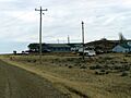
Cat Creek, Montana, around 2005
-
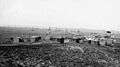
"Tar Shack city" at Cat Creek, 1921
