Cerro del Azufre facts for kids
Quick facts for kids Cerro del Azufre |
|
|---|---|

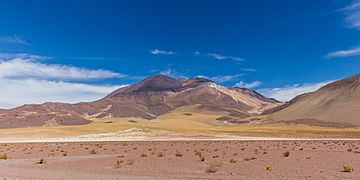
Cerro del Azufre.
|
|
| Highest point | |
| Elevation | 5,846 m (19,180 ft) |
| Geography | |
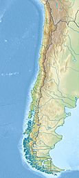
| Location | Chile |
| Parent range | Andes |
| Geology | |
| Mountain type | Stratovolcano |
| Last eruption | Unknown |
Cerro del Azufre is a large stratovolcano in Chile. It is found in the El Loa Province of the Antofagasta Region. This volcano is part of a group of volcanoes that separate two important basins: the Upper Loa River basin and the Salar de Ascotán basin.
To the west of Cerro del Azufre, there is a lava dome called Chanka or Pabellón. Other tall volcanoes, San Pedro and San Pablo, are located to its southwest. They are both about 6,000 meters high.
Contents
Where is Cerro del Azufre?
Cerro del Azufre is in northern Chile. It is very close to the border with Bolivia. The volcano is also south of a large salt flat called Salar de Ascotan.
A major highway (Route 21-CH) passes northwest of the volcano. This road connects the city of Calama to the town of Ollagüe. In the past, people used to mine sulfur on Cerro del Azufre.
What does Cerro del Azufre look like?
Cerro del Azufre is one of the biggest volcanoes in its area. It is about 14 kilometers wide. The volcano reaches a height of 5,846 meters (about 19,179 feet).
It is actually made of two volcanoes that overlap. The northern part has two openings, and the southern part has three. Each part has a summit crater at its top. There might even be lakes inside these craters.
The two parts of the volcano are separated by about 2 kilometers. This area shows signs of being changed by hot water, and there are three old mining spots here.
The northern part of the volcano once had a large sector collapse. This means a big piece of the volcano broke off and slid down, creating a debris avalanche to the north. Later, new lava flows covered this area.
The southern part of the volcano has signs of moraines. These are piles of rocks and dirt left behind by glaciers. There are also deep gorges formed by water erosion. You can also see traces of rock glaciers, which are slow-moving masses of rock and ice.
Two lava domes, Chac-Inca and Cerro Chanka, are located between the two main parts of Cerro del Azufre.
Nearby Volcanoes
The area around Cerro del Azufre has many volcanoes. Many of them are taller than 5,000 meters (about 16,400 feet). These volcanoes formed over millions of years.
Some nearby volcanoes include:
- San Pedro and San Pablo to the south.
- Carasilla to the northwest.
- The Apacheta-Aguilucho volcanic complex to the east. This complex is sometimes considered part of the same group as Cerro del Azufre.
Cerro del Azufre and other volcanoes to its southeast form a chain called the Azufre-Inacaliri volcanic chain. This chain is mostly made of lava flows. The lava can be different types, from basaltic andesite to rhyolite.
How Cerro del Azufre Formed
Cerro del Azufre sits on top of older rocks. These rocks were formed by huge caldera eruptions over the last 10 million years. These eruptions came from a large area called the Altiplano-Puna volcanic complex (APVC).
The APVC is connected to a huge body of partly melted rock deep underground. This body of rock is called the Altiplano-Puna Magma Body. It is about 500,000 cubic kilometers in size. This magma body is likely the source of heat for hot springs and the magma that formed lava domes in the area.
Cracks in the Earth's crust, called strike-slip faults, run through this volcanic area. These cracks seem to have affected where volcanoes formed and where valuable minerals are found. Cerro del Azufre is part of one of these lines of cracks, called the Azufre-Inacaliri lineament.
Scientists have used seismic tomography to study the ground under Cerro del Azufre. They found areas where seismic waves travel slowly. This might mean there are magma chambers (pools of melted rock) under the volcano.
What is Cerro del Azufre made of?
The rocks from Cerro del Azufre are mostly andesite and dacite. These rocks contain crystals called plagioclase phenocrysts.
Hot water has changed some of the rocks around the volcano. This process, called hydrothermal alteration, has created minerals like alunite, gypsum, hematite, kaolinite, and sulfur.
Scientists study the chemical makeup of the rocks. They think the magma that formed Cerro del Azufre came from different sources deep underground. The magma was likely stored at two different levels before eruptions happened.
When did Cerro del Azufre erupt?
Cerro del Azufre had four main periods of volcanic activity:
- First Stage: The oldest lava flows are found on the southern side of the volcano. They are about 1.1 million years old.
- Second Stage: This stage happened between 0.7 and 0.5 million years ago. It formed parts of the western and northern sides of the volcano. This stage included lava flows and thin pyroclastic flows (fast-moving currents of hot gas and volcanic debris). The large sector collapse might have happened during this time.
- Third Stage: This stage formed the southern part of the volcano between 0.5 and 0.3 million years ago. It created lava flows and a lava dome at the summit.
- Fourth Stage: This stage formed the northern part of the volcano. It is not precisely dated, but scientists think it happened between 0.3 and 0.12 million years ago.
The volcano grew at a typical rate for volcanoes in this region. Several lava domes, like Chac-Inca, Pabellón, and Chanca, grew around the main volcano.
Even though some parts of the volcano look young, none of its features are less than 80,000 years old. Because of this, Cerro del Azufre is considered an extinct volcano. This means it is not expected to erupt again.
Hot Springs and Geothermal Energy
Cerro del Azufre does not have active fumaroles (vents that release volcanic gases). However, there are signs of old ones on the western side of the northern part of the volcano.
There are also active hot springs at the northern base of Cerro del Azufre. The water in these springs is about 42 degrees Celsius (107 degrees Fahrenheit).
The area is known for its geothermal fields. These are places where heat from deep inside the Earth comes close to the surface. Cerro Pabellón is one of these fields. As of 2022, it is the only place in this part of the Andes where geothermal power is being produced. This means they are using the Earth's heat to make electricity! The geothermal field might extend over a large area underground, about 25 square kilometers.
See also
 In Spanish: Cerro del Azufre para niños
- List of volcanoes in Chile
- Ollagüe
- Cerro Paniri
- San Pedro de Inacaliri River
 | Chris Smalls |
 | Fred Hampton |
 | Ralph Abernathy |


