
Cline Buttes facts for kids
Quick facts for kids Cline Buttes |
|
|---|---|

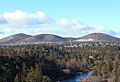
Cline Buttes viewed from the east
|
|
| Highest point | |
| Elevation | 4,117 ft (1,255 m) |
| Geography | |

Cline Buttes
Location in Oregon
|
|
| Location | Deschutes County, Oregon |
| Topo map | USGS Cline Falls, Oregon (44121C3) |
| Geology | |
| Age of rock | late Oligocene or early Miocene epoch |
| Mountain type | Volcanic |
| Climbing | |
| Easiest route | Rough dirt road |
| Normal route | Hiking or biking trails |
The Cline Buttes are a group of three mountains in central Oregon. They were formed by volcanoes a very long time ago. These dome-shaped peaks are found in Deschutes County. They are part of the eastern foothills of the Cascade Range.
The land around the buttes is managed by the Bureau of Land Management. You'll find parts of the Eagle Crest Resort on both sides of the buttes. On the highest peak, there's a special site for the Federal Aviation Administration. It has a beacon that helps airplanes navigate. The Cline Buttes are also a popular spot for hiking and mountain biking.
Contents
What are Cline Buttes?
Where are the Cline Buttes located?
The Cline Buttes are three rounded mountains. They are some of the easternmost foothills of the Cascade mountain range. You can find them near the northwest part of Oregon's high desert. The mountains are in Deschutes County, about 7 miles (11 km) west of Redmond.
The southern peak is the tallest of the three. Its top is 4,117 feet (1,255 meters) above sea level. The Cline Buttes stand alone, with the next taller mountain about 12 miles (19 km) to the south. The buttes have gentle slopes and peaks that look like cones.
How were the Cline Buttes formed?
The Cline Buttes were formed by volcanoes. They were active about 25 million years ago. This happened during a time called the late Oligocene or early Miocene epoch. Their lava flows cover an area of about 5 square miles (13 square kilometers).
The main rock that makes up the mountains is called rhyolite. There is also some basalt. Rhyolite is usually white or light gray. It formed when hot, melted rock (called magma) cooled down inside the Earth. Then, it erupted onto the surface. Over millions of years, the Cline Buttes have been worn down by weather. This is why they have their rounded, dome shape with three separate peaks.
Plants and Animals at Cline Buttes
What kind of plants grow here?
To the west of the Cline Buttes, you'll find forests. These forests have western juniper trees. As you go further, you'll see ponderosa pine, lodgepole pine, and fir trees. This forest stretches towards the high peaks of the Cascade Mountains.
South and east of the mountains, the land is drier. This area is typical of Oregon's high desert. It is mostly covered with juniper trees and sagebrush. The slopes of the Cline Buttes have old juniper trees. Underneath them, you'll find low sagebrush and Rabbitbrush. Other small plants like Granite Gilia and bunch grass also grow here.
What animals live at Cline Buttes?
The Cline Buttes area is home to many different animals. Large mammals include black-tailed deer, elk, coyotes, black bears, bobcats, and cougars.
Smaller animals you might see are American badgers, striped skunks, and different types of rabbits and squirrels. These include black-tailed jackrabbits, white-tailed jackrabbits, mountain cottontails, Belding's ground squirrels, golden-mantled ground squirrels, and least chipmunks.
Many birds also live in the Cline Buttes area. You might spot mountain chickadees, American goldfinches, mountain bluebirds, and Steller's jays. Birds of prey, like golden eagles, red-tailed hawks, and prairie falcons, also fly overhead. Prairie falcons are special because they have a native breeding population here. To protect these birds, some parts of the Cline Buttes are closed to people during certain months of the year.
People and the Cline Buttes
How did Cline Buttes get its name?

The Cline Buttes are named after Doctor Cass A. Cline (1850–1926). He was a dentist and an early land developer in central Oregon. A nearby waterfall on the Deschutes River is also named after him.
Dr. Cline moved to Oregon in 1853. In 1886, he claimed land along the Deschutes River, close to the buttes and falls. Later, he tried to start a town called Cline Falls near the river. At one point, the town had a post office, a school, stores, hotels, and a newspaper. But the town failed because the railroad was built on the other side of the river, through the town of Redmond.
In 1904, gold was found on the Cline Buttes. Over 50 mining claims were quickly made. However, the gold was too expensive to dig out, so mining never really started.
What is the Cline Buttes Recreation Area?
Today, the Bureau of Land Management takes care of the Cline Buttes and the land around them. They have created the Cline Buttes Recreation Area. This area is about 32,000 acres (130 square kilometers) and is being developed for many outdoor activities.
A service road goes up the south side of the mountain to the main summit. This road leads to the Federal Aviation Administration facility. This facility has a radio beacon that helps airplanes navigate. There is also a road on the east side of the mountain that goes to a rock quarry.
What can you do for fun at Cline Buttes?

In the summer, you can enjoy hiking, horseback riding, mountain biking, bird watching, and enjoying the views. There are separate trails for hikers, mountain bikers, and horseback riders. In the winter, you can often still do some activities because there isn't usually too much snow.
The Cline Buttes are especially famous for their mountain bike trails. Some trails are narrow paths that follow the slopes to amazing viewpoints. There are also two downhill trails from the top of the highest peak. These are very challenging and have steep, rocky parts, so they are only for expert bikers. Many lower trails are good for bikers with intermediate skills.
From the top of the Cline Buttes, you can see amazing views. To the west, you can see the Cascade peaks, including the Three Sisters. You can see as far north as Mount Hood and as far south as Mount Bachelor. To the northeast is Smith Rock State Park. To the east, you can see the Powell Buttes and the Ochoco Mountains. Looking south, you'll see parts of the Cline Buttes Recreation Area and Pilot Butte and Paulina Peak in the distance.
Images for kids
-
Cline Buttes viewed from the east
-
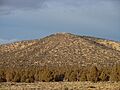
Navigation beacon on south peak
-
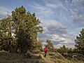
Mountain bike trail on Cline Buttes
