
Crown Point Road facts for kids
Quick facts for kids |
|
|
Historic Crown Point Road
|
|
 |
|

Location in Vermont
|
|
| Location | Off VT 131, Weathersfield, Vermont |
|---|---|
| Area | 4.5 acres (1.8 ha) |
| NRHP reference No. | 74000270 |
| Added to NRHP | December 2, 1974 |
The Crown Point Road was a very important historic road built a long time ago, between 1759 and 1760. Most of this road was in what is now the state of Vermont. The British Army and colonial soldiers built it. Their goal was to connect Fort Crown Point on Lake Champlain to the Fort at Number 4 in Charlestown, New Hampshire.
This road was the first big road in Vermont. It helped new towns and settlements grow after the French and Indian War. Today, you can still see parts of the old road. Some sections look much like they did back then. Others have been paved over, and some have disappeared into the forest. Parts of the road in Weathersfield are even listed on the National Register of Historic Places. This means they are protected as important historical sites.
Contents
Where Did the Crown Point Road Go?
The Crown Point Road started at the Fort at Number 4. This spot is now roughly the center of Charlestown, New Hampshire. It was on the east side of the Connecticut River. The road generally went north. It crossed the river near the mouth of Beaver Brook.
Once in Vermont, the road went north-northwest. It passed through areas that are now Springfield and Weathersfield. Then it turned west across Cavendish. In the middle of Cavendish, it turned more to the north again. It then went west between Plymouth and Ludlow towards Shrewsbury.
The road reached Otter Creek in Clarendon. It then followed that valley north. It went through Rutland, Proctor, and Pittsford. After that, it turned northwest across the hills south of Brandon.
Near where Vermont Routes 30 and 73 meet in northern Sudbury, a side road branched off. This spur went west toward Fort Ticonderoga. It passed through what is now Orwell. The main road kept going northwest. It went through Whiting, Shoreham, and Bridport. Finally, it reached Lake Champlain. It ended across from Fort Crown Point in what is now Addison.
Why Was This Road Built?
In 1759, British forces captured Fort Ticonderoga from the French. This happened during the later parts of the French and Indian War. General Jeffery Amherst led the British. He wanted to make sure Britain controlled the southern end of Lake Champlain.
So, General Amherst ordered two big projects. First, he commanded his troops to build Fort Crown Point. Second, he ordered the construction of the road. This road would connect the new fort to the Fort at Number 4. Fort at Number 4 was the northernmost British outpost on the Connecticut River at that time.
The new road followed an old Native American trail. It ran alongside the Black River in the south. In the north, it followed Otter Creek. Colonial soldiers, led by Colonel John Stark, did the early work. They had to clear trees and stumps. They also built bridges over small streams. In swampy areas, they built "corduroy" sections. This meant laying logs side-by-side to create a stable path.
What Happened to the Road Later?
After the French and Indian War ended, the Crown Point Road became very important. It was a main route for people settling in central southern Vermont. As more and better roads were built, some parts of the Crown Point Road were used less. These sections were eventually abandoned. Other parts continued to be used and were improved over time.
In the late 1800s, people started to remember the road's history. Efforts were made to mark and celebrate its route. This led to placing special markers along or near the road. Some of these markers can still be seen today. In some towns, parts of the original road are still called "Crown Point Road" or "Old Crown Point Road."
A section of the road near Stoughton Pond in northern Springfield is still in good condition. It looks much like it did when it was built. This part, along with other nearby sections in Springfield and Weathersfield, was added to the National Register of Historic Places in 1974. This helps protect these important historical pieces of the road for the future.
Images for kids
-
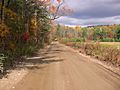
Crown Point Road (now Branch Brook Road) near Weathersfield, Vermont
-
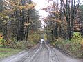
Crown Point Road (now Branch Brook Road) near Weathersfield, Vermont


