
Dhegihan migration facts for kids
| Languages | |
|---|---|
| Omaha-Ponca, Kaw-Osage, Quapaw | |
| Related ethnic groups | |
| Omaha, Ponca, Kaw, Osage, Quapaw |
The Dhegiha people are a group of Native American tribes who share a common history and language. They include the Omaha, Ponca, Kaw (also called Kansa), Osage, and Quapaw tribes. These tribes all speak a similar Dhegiha Siouan language.
Long ago, these tribes were part of one large group called the Hoga. They lived in an area that is now Illinois and Kentucky. Over time, the Hoga people began a long journey on foot, moving across the land. As they traveled, they slowly separated into the five different tribes we know today. Each group became its own independent tribe, settling in different parts of North America, from Nebraska to Arkansas.
Contents
The Hoga: One People Long Ago
_migration_story_according_to_oral_tradition._(Map_improved_2018).png)
The Quapaw, Ponca, Omaha, Osage, and Kaw tribes all have a shared oral tradition. This means they tell stories passed down through generations that say they were once one people. This idea is supported because their tribal groups are organized in similar ways, with family groups called clans. Also, their languages are very much alike, even though the tribes later lived far apart. For example, the Ponca and Omaha settled in Nebraska, the Kaw in Kansas, the Osage in Missouri, and the Quapaw in Arkansas.
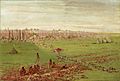
The original tribe called themselves the Hoga. This name means "leaders" or "ancestors." The Hoga people lived in villages. Their homes were made of bark. They made pottery, hunted animals, gathered wild plants, and grew a small amount of corn. According to stories collected by people like James Owen Dorsey and Omaha Indian Francis La Flesche, the early Dhegiha people lived near the lower Ohio River.
For a long time, some experts didn't believe these shared stories. But in more recent years, new studies have shown that the oral histories of these tribes match up with what archaeologists have found. This suggests that the tribes really did come from a common group.
The Great Journey Begins
For reasons that are not fully clear, the Hoga tribe started a long journey down the Ohio River before the year 1673. This move might have happened because their old way of life was changing. It could also have been due to changes in the weather that made it hard to grow corn, or because of sicknesses, or even fights with other Native American groups like the Iroquois and Algonquin Indians.
As they traveled, the Hoga people lived in tents. The bottom edges of their tent covers were held down with stones. Since the Hoga were moving into new areas, their journey sometimes meant they were entering lands where other tribes already lived.
Historians have different ideas about exactly when this journey happened. Some think that parts of the group might have moved into the Missouri/Cahokia area as early as AD 500. Then, the rest of the people might have followed later, perhaps drawn by the large city of Cahokia. The breakup of Cahokia around 1250, or pressure from tribes in the east, could have pushed the Dhegiha people to cross the Mississippi River for good and continue their moves.
First Split: Downstream and Upstream People
When the Hoga reached the mouth of the Ohio River, they began to cross the mighty Mississippi River in boats made of animal skins. This was where the first big separation happened.
Some of the people either followed the Mississippi River south along the eastern shore, or they simply drifted away with the river's current. These people became the Quapaw, which means "Downstream People."
Those who went against the current of the river on the western shore became the Omaha, or "Upstream People."
It is possible that the Iowa Indians joined the Hoga and crossed the Mississippi with them. Other stories say the Iowa first met and joined the Hoga later, either on the Lower Missouri River or at a place on the Des Moines River.
Moving Upstream: Osage, Kaw, Omaha, and Ponca
The main group of the Hoga continued their journey north along the Mississippi River. This large group would later separate into the Osage, Kaw, Omaha, and Ponca tribes.
One story says this large group reached the mouth of the Missouri River and followed it. For a while, they lived in the area of what is now Gasconade County and Osage County, Missouri. Eventually, they continued their journey and reached the Osage River. Here, the group split again. This division happened because of disagreements, possibly over how to share animal sinews, which were used for threads and strings.
Some decided to explore the unknown land by following the Osage River. These people became the Osage Indians and the Kaw (or Kansa) Indians. The Kaws may have then turned back and followed the Missouri River north to the Kansas River, where they settled.
Later, the Osage and the Quapaw, who were once one people, became enemies. The Omaha in Nebraska also came to be seen as enemies by the Osage.
The Omaha, feeling upset, left the Osage/Kaw group and continued traveling along the southern banks of the Missouri River. They crossed to the other side at the mouth of the Chariton River.
There are different ideas about how the people reached the pipestone quarry in Minnesota. One story says they followed the Chariton River and then the Des Moines River (the green route on the map). Another version says they traveled up the Missouri River and later the Big Sioux River (the orange route on the map). A third story says they went up the Mississippi River instead of the Missouri (the yellow route on the map). From the Des Moines River, they followed a tributary to its source and found the quarry.
Settling Near the Pipestone Quarry

The people found red, soft stone called catlinite in this area. They used a large piece of it to make the bowl for a sacred pipe. This pipe later became an important part of the Ponca tribe's traditions. (The Ponca finished their long migration to northeastern Nebraska before they finally made the stem for the pipe).
The people built a village near the Big Sioux River, possibly at the Blood Run Site in northwestern Iowa. However, they were attacked by different groups of Sioux (Dakota) and had to leave their settlement after a major battle. A historical record from the Yanktonai Sioux says that in 1685, the Santee Dakota fought with the Omaha tribe. Many who died in this battle were buried in a large mound near the village.
In 1879, Yankton Sioux chief Strikes-the-Ree said that this war was caused by both sides claiming ownership of the pipestone quarry.
Moving Again
_and_Les_Maha_Nation_errente.png)
After the battle, the people moved south. Then, they seemed to head north again, following the Missouri River upstream. They cut wood for a sacred pole at a lake. Some Omahas believed this was Lake Andes in South Dakota. This might have happened in the late 1600s.
The people probably moved back to a place near the mouth of the Big Sioux River. Living east of the Missouri, they bothered the Arikara Indians who lived on the western side. Over time, the Omaha settled in a new village on the Big Sioux and made peace with the Arikara (and also the Cheyenne and the Oto). The Arikara women taught the Omaha how to build earth lodges.
The village on the Big Sioux River was attacked by other tribes. The Omaha, still followed by the Iowa, left this dangerous area for good. All their travel was still on foot.
A French explorer named Pierre-Charles Le Sueur wrote things that suggest the Omaha were somewhere on the Upper Big Sioux River before the end of the 1600s. After 1714, French records show the Omaha Indians in other places.
The Ponca Become a Tribe
The Upstream People (Omaha and Iowa) went north again and crossed the Missouri River at the mouth of White River in South Dakota. There is some evidence that they paused their journey here for a while. It seems that the Ponca clan, which was part of the Omaha, started to become more independent in this new area. While the Ponca explored the land to the west, either as a clan or as a separate tribe, the rest of the Omahas and the Iowa stayed near the White River.
The Ponca traveled all the way to the Black Hills. They then returned to the Omaha and the Iowa, and the three groups began a joint journey down the Missouri River.
The Ponca eventually settled near the city of Niobrara, Nebraska. The Omaha and the Iowa continued downstream, but they stayed within the area that would later become the state of Nebraska. This final and lasting split between the Ponca and Omaha may have happened between 1714 and 1718.
The Ponca would make long journeys from their villages to the Black Hills and even further west. On one trip to the Black Hills, they fought with the "Padouca" – who were either Plains Apache or Comanche Indians. Later, they made a truce, and the Ponca received their first horses from the Padouca.
The first time white people mentioned the Ponca tribe was in 1785. A Spanish document correctly described the Ponca homeland as the northeastern corner of Nebraska.
Images for kids
-
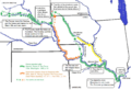
The migration story of the Quapaw, Omaha, Osage, Kansa (Kaw) and Ponca according to oral traditions
-
The Omaha battled with different Dakotas for ownership to the pipestone quarry in present Minnesota
-
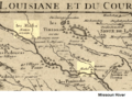
Detail of French cartographer De L'isle 1718 map. It shows the villages of "Maha" (the Omaha Indians) along the "R[iviere] du Rocher" (Rock River), which is thought to be the present-day Big Sioux River. On the east side of the river is an Iowa village. It also shows "Les Omaha Nation errante" (The wandering Omaha Nation) moving around in present-day South Dakota. This might actually be the separated Ponca, who were not yet known as their own tribe.
