
Dulwich Hill facts for kids
Quick facts for kids Dulwich HillSydney, New South Wales |
|||||||||||||||
|---|---|---|---|---|---|---|---|---|---|---|---|---|---|---|---|
 |
|||||||||||||||
| Established | 1892 | ||||||||||||||
| Postcode(s) | 2203 | ||||||||||||||
| Elevation | 42 m (138 ft) | ||||||||||||||
| Area | 2.1 km2 (0.8 sq mi) | ||||||||||||||
| Location | 7.5 km (5 mi) inner-west of Sydney CBD | ||||||||||||||
| LGA(s) | Inner West Council | ||||||||||||||
| State electorate(s) | Summer Hill | ||||||||||||||
| Federal Division(s) | |||||||||||||||
|
|||||||||||||||
Dulwich Hill is a friendly suburb located in the Inner West area of Sydney, New South Wales, Australia. It's about 7.5 kilometres south-west of the main city centre. This suburb is part of the Inner West Council area and reaches down to the banks of the Cooks River.
Contents
History of Dulwich Hill
Dulwich Hill gets its name from a place called Dulwich in London, England. The name "Dulwich Hill" first appeared in a directory in 1892. Before that, it had a few different names.
After European settlers arrived, it was first known as Petersham Hill. Later, it was called Wardell's Bush. This name came from Dr Robert Wardell, who owned a lot of land in the area. Other names for the area included South Petersham and Fern Hill.

In 1889, the suburb became part of Sydney's growing tram network. Like many suburbs in the inner-west, Dulwich Hill grew very quickly in the early 1900s. Because of this, you can see many beautiful examples of Australian Federation architecture here. You'll also find buildings in Edwardian, Gothic, and Italianate styles. The tram system ran until 1957.
The old public school on Seaview Street is now the Dulwich Hill High School of Visual Arts and Design. This building is special and is listed on the Register of the National Estate. It was designed in the Romanesque style and built around 1892. Also on this street was the old Dulwich Hill Library, which was a cottage built in the Victorian Gothic style.
Shopping and Services
Dulwich Hill has two main shopping areas. There are a few shops on Wardell Road, close to the Dulwich Hill railway station. The main shopping area is around the northern end of Marrickville Road, where it meets New Canterbury Road.
This shopping area grew up around the old tram line, which is now used by buses. Many cafes and restaurants have opened here, making the suburb a popular place to visit. The local council improved the shopping street in the early 2000s, making it look even better. Dulwich Hill has a library and a post office. However, it never had its own town hall or police station. The closest police station is in Marrickville.
Schools in Dulwich Hill

Dulwich Hill has three primary schools. These are Dulwich Hill Public School, St Maroun's College, and St Paul of the Cross, which is a Catholic school.
There is also one high school, Dulwich High School of Visual Arts & Design, on Seaview Street. This school was the first Visual Arts school in Australia. Some famous people who went to the high school include former rugby league coach Terry Fearnley, tennis player Phil Dent, and opera singer Yvonne Minton.
Getting Around Dulwich Hill
Old Tram System
Until the late 1950s, electric trams used to run to Dulwich Hill and the Cooks River. You could catch a tram from Circular Quay all the way here. The tram line to Dulwich Hill split off from the Cooks River line in Newtown. It went through Marrickville and Dulwich Hill, using Victoria and Marrickville Roads. There was a special loop at the Canterbury Road end for trams to turn around.
Modern Public Transport
.jpg)
Today, Dulwich Hill has a train station, four light rail stops, and several bus routes.
The Dulwich Hill railway station is on Wardell Road, in the southern part of the suburb. Trains on the Bankstown Line of the Sydney Trains network stop here. These trains offer regular services to the Sydney city centre and the south-western suburbs.
The Inner West Light Rail has four stops in Dulwich Hill. These are Dulwich Hill (next to the train station), Dulwich Grove, Arlington, and Waratah Mills. While the train is faster for getting to the city, the light rail is useful for travelling to other nearby areas. You can also change to a train at Lewisham railway station.
Several bus routes connect Dulwich Hill to the Sydney city centre. The 426, 428, and 412 routes are the main ones. The 426 bus starts near Marrickville and New Canterbury Roads and goes along Marrickville Road. The 428 bus runs from Canterbury station along New Canterbury Road. Both of these routes join up in Enmore and continue to the city. The 412 bus comes up Wardell Road, passing the train station, before heading towards Marrickville and Petersham. All these city buses end at Martin Place in the CBD.
Other bus routes in the suburb include the 445, 418, and 425. The 445 goes from Campsie station to Balmain. The 418 travels between Bondi Junction and Burwood. The 425 goes to Tempe and runs only during the day on weekdays and Saturdays. All these bus services are run by Transit Systems.
People of Dulwich Hill
According to the 2016 census, there were 13,715 people living in Dulwich Hill. Most people (58.7%) were born in Australia. Other common birthplaces included England (3.4%), Greece (3.1%), New Zealand (2.2%), Vietnam (2.1%), and the Philippines (1.6%).
Most people (61.1%) spoke only English at home. Other languages spoken included Greek (5.6%), Arabic (3.2%), Vietnamese (2.9%), Portuguese (2.4%), and Spanish (2.0%). When asked about religion, the most common answers were No Religion (37.3%) and Catholic (23.8%).
Most homes in Dulwich Hill are flats or apartments (54.0%). There are also separate houses (31.0%) and semi-detached homes (11.3%).
Famous People from Dulwich Hill
- Leisel Jones, Olympic swimmer
- Queenie Paul, vaudeville entertainer
- Joe Hildebrand, journalist
- William Shakespeare, singer
How Dulwich Hill is Governed

Dulwich Hill is mainly in a federal voting area called Grayndler. This area is currently represented by Anthony Albanese from the Australian Labor Party (ALP). He became the leader of the Labor party after the 2019 election. The Grayndler area has been represented by the ALP since 1949.
A small part of Dulwich Hill, south of the railway line, is in another federal voting area called Barton. This area is represented by Linda Burney, also from the Australian Labor Party (ALP). She is the first Aboriginal woman to be elected to the House of Representatives.
At the state level, Dulwich Hill is in the electoral district of Summer Hill. This area has been represented by Jo Haylen from the Labor party since 2015.
Locally, Dulwich Hill is part of the Inner West Council. This council was created in 2015. Before that, Dulwich Hill was part of the Marrickville Council, which joined with two other councils to form the Inner West Council.
Sports and Fun
Arlington Recreation Ground is a park in Williams Parade. It's home to the Dulwich Hill FC soccer club, which plays in the NSW Super League. The Stanmore Hawks soccer club also plays here.
Homes in Dulwich Hill
Many homes in Dulwich Hill were built in the early 1900s. You can find well-preserved houses from the Federation and Interwar periods. For example, the Abelgeldie Estate and the area around Hoskins Park are special heritage areas. The old freight line, which is now the light rail line, runs through Dulwich Hill. This area used to be for factories, but now it has mostly been turned into modern apartment buildings.
Churches in Dulwich Hill
Dulwich Hill has several churches for different religious groups. These include Anglican, Catholic, Greek Orthodox, and Salvation Army churches.
-
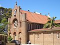
St Marouns Catholic Monastery
-
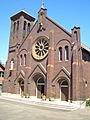
St Paul of the Cross Catholic Church


