Dunnellon, Florida facts for kids
Quick facts for kids
Dunnellon, Florida
|
||
|---|---|---|
| City of Dunnellon | ||
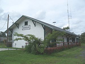
The former Atlantic Coast Line Railroad depot in Dunnellon
|
||
|
||
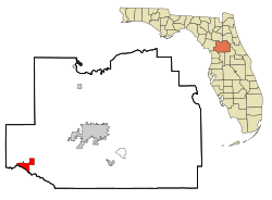
Location in Marion County and the state of Florida
|
||
| Country | ||
| State | ||
| County | Marion | |
| Settled | 1887 | |
| Incorporated | 1891 | |
| Government | ||
| • Type | Council–Manager | |
| Area | ||
| • Total | 9.11 sq mi (23.61 km2) | |
| • Land | 8.82 sq mi (22.83 km2) | |
| • Water | 0.30 sq mi (0.77 km2) | |
| Elevation | 49 ft (15 m) | |
| Population
(2020)
|
||
| • Total | 1,928 | |
| • Density | 218.69/sq mi (84.43/km2) | |
| Time zone | UTC-5 (Eastern (EST)) | |
| • Summer (DST) | UTC-4 (EDT) | |
| ZIP codes |
34430-34432
|
|
| Area code(s) | 352 | |
| FIPS code | 12-18675 | |
| GNIS feature ID | 0281879 | |
Dunnellon is a city in Marion County, Florida, United States. It's a part of the larger Ocala area. In 2020, about 1,928 people lived there. This was a small increase from 1,733 people in 2010.
Contents
History of Dunnellon
Dunnellon was started in 1887. Two years later, in 1889, a valuable mineral called phosphate was found nearby. This discovery led to a big mining boom, which was the first of its kind in Florida! The city was officially made a city in 1891.
Miners first dug for phosphate in and around the Rainbow River, which was then called Blue Run. They used the river's natural flow to move the phosphate. One of the old mining spots is now a neighborhood called 'Blue Cove'.
The phosphate mining slowed down in Dunnellon by the early 1910s. Mining operations then moved south to the Polk County area. By the 1960s, Dunnellon's last mine closed. Even after the mining boom ended, Dunnellon kept going. Other nearby towns that relied on phosphate, like Romeo and Brewster, did not survive.
Some parts of Dunnellon were used to film the 2001 horror movie Jeepers Creepers. A lot of filming happened on Tiger Trail, which is also known as High School Road. This road is near Rainbow Springs State Park.
Where is Dunnellon?
Dunnellon is in the southwestern part of Marion County. It's about 76 miles (122 km) north of Tampa. The Withlacoochee River runs along its southwest side. This river forms the border with Citrus County. To the north, Dunnellon is next to Rainbow Springs.
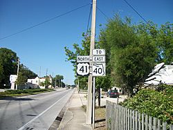
U.S. Route 41 is a main road that goes through the city. It goes north 24 miles (39 km) to Williston. It also goes south 18 miles (29 km) to Inverness. Ocala, which is the main city of Marion County, is about 24 miles (39 km) northeast.
Dunnellon covers a total area of about 9.1 square miles (23.6 square kilometers). Most of this area, about 8.8 square miles (22.8 square kilometers), is land. The rest, about 0.3 square miles (0.77 square kilometers), is water. The Rainbow River flows into the Withlacoochee River in Dunnellon. From there, the combined rivers flow west towards the Gulf of Mexico.
Weather in Dunnellon
The weather in Dunnellon has hot and humid summers. The winters are usually mild. This type of weather is called a humid subtropical climate.
People of Dunnellon
| Historical population | |||
|---|---|---|---|
| Census | Pop. | %± | |
| 1890 | 532 | — | |
| 1900 | 700 | 31.6% | |
| 1910 | 1,227 | 75.3% | |
| 1920 | 1,185 | −3.4% | |
| 1930 | 1,194 | 0.8% | |
| 1940 | 1,066 | −10.7% | |
| 1950 | 1,110 | 4.1% | |
| 1960 | 1,079 | −2.8% | |
| 1970 | 1,146 | 6.2% | |
| 1980 | 1,427 | 24.5% | |
| 1990 | 1,624 | 13.8% | |
| 2000 | 1,898 | 16.9% | |
| 2010 | 1,733 | −8.7% | |
| 2020 | 1,928 | 11.3% | |
| U.S. Decennial Census | |||
The table above shows how Dunnellon's population has changed over the years.
Population in 2010 and 2020
| Race | Pop 2010 | Pop 2020 | % 2010 | % 2020 |
|---|---|---|---|---|
| White (NH) | 1,453 | 1,543 | 83.84% | 80.03% |
| Black or African American (NH) | 158 | 125 | 9.12% | 6.48% |
| Native American or Alaska Native (NH) | 2 | 5 | 0.12% | 0.26% |
| Asian (NH) | 12 | 13 | 0.69% | 0.67% |
| Pacific Islander or Native Hawaiian (NH) | 0 | 0 | 0.00% | 0.00% |
| Some other race (NH) | 5 | 8 | 0.29% | 0.41% |
| Two or more races/Multiracial (NH) | 17 | 66 | 0.98% | 3.42% |
| Hispanic or Latino (any race) | 86 | 168 | 4.96% | 8.71% |
| Total | 1,733 | 1,928 |
In 2020, there were 1,928 people living in Dunnellon. These people lived in 1,272 households, and 546 of these were families. In 2010, there were 1,733 people, 824 households, and 377 families.
Getting Around Dunnellon
Main Roads
 U.S. Route 41 is the most important road in Dunnellon. It's a major highway that goes from south to north, connecting places like Miami all the way to the Upper Peninsula of Michigan.
Other important roads are County Roads 40, 336, and 484. These roads all run along Pennsylvania Avenue at some point.
 County Road 40 starts near the Gulf of Mexico in Yankeetown. It joins with CR 336 before entering Dunnellon. It then turns north onto US 41.
 County Road 336 comes from western Levy County. It joins with CR 40 west of Dunnellon. It ends at US 41, where CR 40 turns north.
 County Road 484 is a big road in southern Marion County. It starts where CR 336 ends and CR 40 turns. It goes to Marion Oaks and as far east as US 27-441 in Summerfield.
Other Ways to Travel
In the past, Dunnellon had four different railroad lines. Two were owned by the Atlantic Coast Line Railroad, one by the Seaboard Air Line Railroad, and one by the Florida Northern Railroad. Today, you can launch a boat into the Withlacoochee River. Just outside the city, there's also the Dunnellon/Marion County Airport along CR 484.
Famous People from Dunnellon
- Terrence Brooks: An American football player who played safety for the New York Jets in the NFL.
- Max Lanier: A former MLB baseball player.
- Lerentee McCray: A former NFL outside linebacker/defensive end for the Denver Broncos.
- Ernie Mills: A former NFL football player for the Pittsburgh Steelers.
- Terry Plumeri: A classical composer, orchestra conductor, double bassist, and film score composer.
See also
 In Spanish: Dunnellon para niños
 | Delilah Pierce |
 | Gordon Parks |
 | Augusta Savage |
 | Charles Ethan Porter |


