
Sint Maarten facts for kids
Quick facts for kids
Sint Maarten
|
|||
|---|---|---|---|
|
|||
| Motto(s): | |||
| Anthem: "O Sweet Saint Martin's Land" | |||

Location of Sint Maarten (circled in red)
|
|||

Sint Maarten is located on the southern half of
the island of Saint Martin. |
|||
| Sovereign state | Kingdom of the Netherlands | ||
| Before separation | Netherlands Antilles | ||
| Country status | 10 October 2010 | ||
| Capital | Philipsburg 18°02′N 63°03′W / 18.033°N 63.050°W |
||
| Largest city | Lower Prince's Quarter | ||
| Official languages | |||
| Demonym(s) | St. Maartener | ||
| Government | Parliamentary representative democracy within a constitutional monarchy | ||
|
• Monarch
|
Willem-Alexander | ||
|
• Governor
|
Eugene Holiday | ||
| Wycliffe Smith | |||
| Legislature | Estates of Sint Maarten | ||
| Area | |||
|
• Total
|
37 km2 (14 sq mi) | ||
|
• Water (%)
|
negligible | ||
| Highest elevation | 383 m (1,257 ft) | ||
| Population | |||
|
• 2011 census
|
33,609 | ||
|
• Density
|
1,110/km2 (2,874.9/sq mi) (10th) | ||
| GDP (PPP) | 2014 estimate | ||
|
• Total
|
$365.8 million | ||
|
• Per capita
|
$66,800 | ||
| Currency | Netherlands Antillean guilder (ANG) | ||
| Time zone | UTC-4:00 (AST) | ||
| Mains electricity | 120 V–60 Hz | ||
| Driving side | right | ||
| Calling code | +1-721 | ||
| ISO 3166 code |
|
||
| Internet TLD | .sx | ||


Sint Maarten is a small country in the sunny Caribbean Sea. It's part of the Kingdom of the Netherlands. About 40,000 people live on its 37 square kilometers (14 square miles). Sint Maarten takes up the southern part of an island called Saint Martin. The northern part of the island is French, called Saint-Martin. This is the only place where France and the Netherlands share a border! The capital city of Sint Maarten is Philipsburg.
Before October 10, 2010, Sint Maarten was known as an 'Island Territory' within the Netherlands Antilles. It was one of five such territories.
In September 2017, a very strong storm called Hurricane Irma hit the island. It was a Category 5+ hurricane and caused a lot of damage to buildings and roads.
As of 2018, Sint Maarten has one of the highest GDP per capita (money earned per person) in the world. This shows how strong its economy is.
Contents
What's in a Name?
The island was named by Christopher Columbus. He saw it on November 11, 1493. This day is a special holiday for Saint Martin of Tours. So, Columbus named the island in his honor.
History of Sint Maarten
Early People
Sint Maarten has been home to people for a very long time. Scientists have found signs of humans living there as far back as 2000 BC. These early people likely came from South America. The first known group was the Arawak people. They settled on the island between 800 BC and 300 BC. Later, around 1300-1400 AD, the Carib people arrived. They were more warlike and started to replace the Arawak.
European Arrival

Christopher Columbus was the first European to see the island in 1493. Even though Spain claimed the island, other European countries were interested too. France, Britain, and the Netherlands all wanted a piece of it. France wanted to colonize islands in the Caribbean. The Dutch saw Saint Martin as a good stop between their colonies in New York and Brazil.
Sadly, the native people on the island started to die out. They caught diseases from the Europeans that their bodies couldn't fight off.
The Dutch built a fort called Fort Amsterdam in 1631. They also started mining salt on the island. But Spain and the Netherlands were fighting a war at the time. In 1633, the Spanish took over Saint Martin and kicked out the Dutch. They built their own fort to protect the area. The Dutch tried to get the island back in 1644, but they failed.
However, the war ended in 1648. Spain then decided the island wasn't important anymore and left it.
With the island free, both the Dutch and the French quickly returned. The Dutch came from Sint Eustatius, and the French came from Saint Kitts. They fought a bit at first. But then they realized it was better to share. In 1648, they signed the Treaty of Concordia. This treaty divided the island into two parts. The French had more ships nearby during the talks, which helped them get more land.
Even with the treaty, the border changed 16 times between 1648 and 1816! The whole island was under French control from 1795 to 1815. In the end, the French side got 53 square kilometers (20 square miles), which is 61% of the island. The Dutch side got 34 square kilometers (13 square miles), or 39%.
Slavery and Freedom
To work on the new farms for cotton, tobacco, and sugar, the French and Dutch brought many enslaved people from Africa. Soon, there were more enslaved people than Europeans. They were treated very badly and often rebelled.
In 1848, France ended slavery in its colonies, including the French side of Saint Martin. Enslaved people on the Dutch side heard this news. They protested and threatened to escape to the French side to be free. Because of this, the local Dutch leaders freed the enslaved people on their side of the island. However, slavery was not officially ended in all Dutch colonies until 1863.
The 20th Century

After slavery ended, the big farms declined, and the island's economy struggled. In 1939, things got better when Sint Maarten became a duty-free port. This meant goods could be bought and sold without extra taxes, which helped trade. During World War II, in 1941, a German submarine attacked the island.
Tourism started to grow in the 1950s. Princess Juliana International Airport became one of the busiest airports in the Caribbean. For many years, a powerful businessman named Claude Wathey led Sint Maarten's government.
The number of people living on the island grew a lot during this time. From just 5,000 people, it reached about 60,000 by the mid-1990s. Many people moved to Sint Maarten from nearby islands, Haiti, the Dominican Republic, the United States, Europe, and Asia. This meant that the people born on the island became a smaller part of the population.
In 1983, Sint Maarten became an "island territory" within the Netherlands Antilles. This gave it a lot of self-rule. It had its own island council and executive council. A Lieutenant Governor, appointed by the Dutch King or Queen, also helped lead.
In 1995, Hurricane Luis hit the island. It caused huge damage and 12 people died.
The 21st Century
In 1994, the Netherlands and France signed a treaty. This agreement allowed them to work together on border checks for certain flights. The treaty officially started in 2007.
On October 10, 2010, Sint Maarten became a constituent country within the Kingdom of the Netherlands. This made it an equal partner with Aruba, Curaçao, and the Netherlands itself.
Sint Maarten also got its own internet address code, .sx, which became available in 2012.
Hurricane Irma's Impact

_05.jpg)

Hurricane Irma hit Sint Maarten on September 6, 2017. It caused massive damage. Four people died, and 34 were injured. Princess Juliana Airport was badly damaged but partly reopened in two days. This allowed aid flights to land and people to be evacuated.
By September 8, many people had no basic supplies, and looting became a big problem. Reports said that 70% of the buildings on the Dutch side were destroyed. The Dutch Red Cross estimated that almost a third of all buildings were destroyed. Over 90% of structures on the island were damaged.
The Prime Minister of the Netherlands sent aid, police, and military help. The Prime Minister of Sint Maarten asked for more help from the Dutch government. Another storm, Hurricane Jose, was approaching, so a warning was issued.
The Prime Minister of Sint Maarten said that many homes and schools were destroyed. He worried that the tourist season would be lost. This would hurt the economy a lot. Luckily, Hurricane Jose did not cause much more damage.
A state of emergency was announced because of the looting. About 230 Dutch soldiers patrolled the island. By September 10, about 1,200 Americans were flown out of Sint Maarten. Cruise ships also came to deliver supplies and evacuate people.
King Willem-Alexander of the Netherlands visited Sint Maarten after the hurricane. He was shocked by the destruction. He asked the European Union for help. The EU later promised €2 billion for disaster relief. This money would help restore water and sanitation. The Red Cross, the Dutch government, and Dutch citizens also raised money for the island.
Rebuilding After the Storm
On October 10, 2017, Princess Juliana International Airport started commercial flights again. They used temporary buildings while the main airport was being repaired.
By March 2018, the airport could handle some flights from the US, Canada, and Europe. A new departure area was used during the rebuilding.
Just over a year after Hurricane Irma, Sint Maarten's cruise ship industry had recovered. In 2018, more than 1 million cruise passengers visited the island.
Phone and internet services were restored. Most homes had electricity and drinking water again. Some hotels and tourist places were open, and more were getting ready. Cruise ships were arriving regularly, bringing many visitors.
Geography of Sint Maarten

Sint Maarten is on the southern part of the island of Saint Martin. The northern part is the French territory of Saint Martin. To the north, across a channel, is the British territory of Anguilla. To the southeast are the French island of Saint Barthélemy and the Dutch islands of Saba and Sint Eustatius.
Sint Maarten is 34 square kilometers (13 square miles) in size. The land is mostly hilly. The highest point is Mount Flagstaff, which is 383 meters (1,257 feet) tall. The area near the airport is flatter. It includes the Dutch part of the Simpson Bay Lagoon. The Great Salt Pond is north of Philipsburg. There are also several small islands off the coast, like Cow and Calf, and Pelikan Key.
Images for kids
-
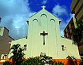
Catholic Church St. Martin of Tours in Philipsburg
-
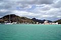
Many tourists come to use Sint Maarten's beaches.
-
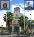
Courthouse on Sint Maarten
-
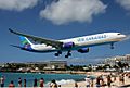
Tourists watch a low flying plane over the beach
-
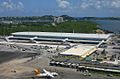
Princess Juliana International Airport
-
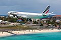
An Aeroplane landing at the airport.


_on_short_finals_at_Princess_Juliana_Airport.jpg)
See also
 In Spanish: San Martín (Países Bajos) para niños
