Free Territory of Trieste facts for kids
Quick facts for kids
Free Territory of Trieste
|
|||||||||||
|---|---|---|---|---|---|---|---|---|---|---|---|
| 1947–1954 | |||||||||||
|
Anthem: Inno Di San Giusto
"Hymn to Saint Justus" |
|||||||||||
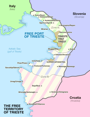
Zone A (green) and Zone B (blue and pink), indicating how the territory was split following its dissolution
|
|||||||||||
| Status | Independent territory under direct responsibility of the United Nations Security Council | ||||||||||
| Capital and largest city
|
Trieste | ||||||||||
| Official languages | Italian · Slovene · Serbo-Croatian · English (only for administrative purposes) | ||||||||||
| Religion | Catholicism, Serbian Orthodox, Judaism | ||||||||||
| Demonym(s) | Triestine | ||||||||||
| Government | Temporary UNSC military government |
||||||||||
| Governor (Zone A) | |||||||||||
|
• 1945 (first)
|
Bernard Freyberg | ||||||||||
|
• 1951–1954 (last)
|
John Winterton | ||||||||||
| Governor (Zone B) | |||||||||||
|
• 1945–1947 (first)
|
Dušan Kveder | ||||||||||
|
• 1951–1954 (last)
|
Miloš Stamatović | ||||||||||
| Legislature | People's Assembly | ||||||||||
| Historical era | Cold War | ||||||||||
|
• Trieste operation
|
30 April 1945 | ||||||||||
|
• UNSC Resolution 16
|
10 January 1947 | ||||||||||
| 10 February 1947 | |||||||||||
|
• London Memorandum
|
5 October 1954 | ||||||||||
|
• Treaty of Osimo
|
10 November 1975 | ||||||||||
| Currency | Italian lira (Zone A) Triestine lira (Zone B) |
||||||||||
|
|||||||||||
| Today part of | Croatia Slovenia Italy |
||||||||||
The Free Territory of Trieste was a special independent area in Southern Europe. It was located between northern Italy and Yugoslavia, right on the Adriatic Sea. After World War II, the United Nations Security Council took direct responsibility for this territory. For seven years, it acted like a "free city."
This territory was created on February 10, 1947. It was part of the Treaty of Peace with Italy. The goal was to create a neutral country for people from different backgrounds. It also aimed to reduce arguments over land between Italy and Yugoslavia. Trieste was very important for trade with Central Europe. The territory officially started on September 15, 1947. It was split into two parts: Zone A and Zone B. Zone A included the city of Trieste and a small coastal area. Zone B was a part of the Istrian peninsula.
The Free Territory of Trieste officially ended in 1954. Its land was given to Italy and Yugoslavia. This decision was made permanent much later by the Treaty of Osimo in 1975.
Contents
Geography of Trieste
The Free Territory of Trieste covered about 738 square kilometers (285 square miles). It was located around the Bay of Trieste. About 330,000 people lived there. It shared borders with the new Italian Republic to the north. To the south and east, it bordered Yugoslavia.
The territory had several rivers, including the Rižana, Dragonja, and Timavo. Its highest point was Monte Cocusso, which is 668 meters (2,192 feet) high.
History of the Territory
Trieste had been part of the Habsburg monarchy since 1382. The nearby region of Istria was split between the Habsburg monarchy and the Republic of Venice for centuries. The people living in this area were very diverse. Different groups were the majority in different parts of the territory.
Most people in the cities and along the coast spoke Italian. However, there were many Slovenes, Serbs, and Croats. In the Trieste area, Slovenes made up about a third of the population by the end of World War I. Most of them had moved there after 1880. The countryside was mostly Slovene or Croatian. There were also smaller groups like Istro-Romanians, Greeks, Albanians, and a strong Triestine Jewish community.
The local Triestine language shows this mix of cultures. It is based on Venetian, but it also has words from German, Slovene, and Greek. The local Slovenian and Serbo-Croatian dialects also shared words with Triestine.
After World War I, Italy took over Trieste and Istria from Austria-Hungary. This area became known as the Julian March. In 1924, Italy also took over the city of Rijeka (then called Fiume).
During the 1920s and 1930s, the Slavic population faced forced "Italianization." This meant they were pressured to become more Italian. They also faced unfair treatment under the Italian fascist government. Fascist groups sometimes used violence. For example, they burned the Slovene National Hall in Trieste in 1920. Some Slovenes and Croats moved to Yugoslavia. Others joined a resistance group called TIGR. This group used violent methods against Italian authorities.
World War II and Its Impact
Italy joined Nazi Germany as an Axis power in World War II in 1940. When the Fascist government fell in 1943, Germany occupied the area. They created a special zone called the Operational Zone of the Adriatic Littoral, with Trieste as its capital.
In May 1945, Yugoslav and Slovenian forces entered Trieste. The next day, New Zealand troops arrived. They forced the surrender of the German soldiers in Trieste. An agreement was made to divide the territory. Yugoslav troops left the area controlled by the Allies by June 12, 1945. This created the Morgan Line, which was a temporary border.
Creating the Territory and Its Government
In January 1947, the United Nations Security Council approved a plan to create a free state in Trieste. This plan was called Resolution 16. On September 15, 1947, the peace treaty between the United Nations and Italy was approved. This officially created the Free Territory of Trieste. The official languages were Italian and Slovene. Serbo-Croatian could also be used in some parts of Zone B.
However, the territory never got its own full government. It remained under military control, split into two zones. Zone A, which included Trieste, was managed by British and American forces. Zone B, which included north-western Istria, was managed by the Yugoslav People's Army.
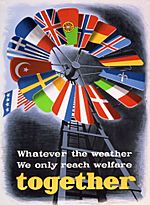
Between 1947 and 1948, the Soviet Union blocked the appointment of a governor for the territory. Because of this, the United States, United Kingdom, and France suggested that the territory should go back to Italy. No governor was ever appointed. So, the territory never truly acted as an independent state. However, its special status was generally respected. It even participated in the Marshall Plan, a program to help Europe recover after the war.
The Allied Military Government managed Zone A. It had about 5,000 American and 5,000 British soldiers to keep the peace. In 1949, Zone A had about 310,000 people. This included about 239,200 Italians and 63,000 Slovenes. Zone B had a mix of Italians, Slovenes, and Croats. Elections were held twice, in 1949 and 1952, but only for local city councils. There were never elections for the territory's main assembly.
The End of the Territory
On October 5, 1954, an agreement called the London Memorandum was signed. This agreement gave Zone A, including Trieste, to Italy for normal management. Zone B, which had been under communist rule since 1947, was given to Yugoslavia. Yugoslavia also received some areas from Zone A, including the city of Koper and several villages.
In 1975, the Treaty of Osimo was signed. This treaty made the division of the former Free Territory of Trieste permanent. It officially ended any remaining claims by Italy and Yugoslavia.
Governors of the Territory
Zone A Military Commanders
| Governor | In office | Country |
|---|---|---|
| Maj. Gen. Bernard Freyberg * | May 2, 1945 – July 1945 | New Zealand |
| Col. Alfred Connor Bowman * | July 1945 – July 1947 | United States |
| Col. James Jewett Carnes * | July 1947 – September 15, 1947 | |
| Maj. Gen. Sir Terence Airey | September 15, 1947 – March 31, 1951 | United Kingdom |
| Maj. Gen. Sir John Winterton | April 1, 1951 – October 26, 1954 |
Zone B Military Commanders
| Governor | In office | Country |
|---|---|---|
| Dušan Kveder * | May 1, 1945 – September 1947 | Yugoslavia |
| Mirko Lenac | September 15, 1947 – March 1951 | |
| Miloš Stamatović | March 1951 – October 25, 1954 |
*Governors of all Julian March prior to the establishment of the Territory.
Economy of the Territory
The economy of the Free Territory of Trieste depended on its ports. These included the Free Port of Trieste and the Port of Koper. The Free Port of Trieste had a special "free zone" status. This status allowed goods to be transported through the area without customs duties. This special status was created in 1719 and confirmed by the 1947 Treaty of Peace with Italy. It is still recognized by the international community today.
Population Changes
After the territory was divided in the late 1940s, many people moved. Up to 40,000 people, mostly Italians, left the Yugoslav Zone B. They moved to the Italian Zone A. Some felt pressured to leave, while others simply preferred not to live in Yugoslavia. In Yugoslavia, those who left were called optanti (choosers). But they called themselves esuli (exiles). About 14,000 Italians chose to stay in the Yugoslav zone. In 1949, the Free Territory of Trieste had about 370,000 residents.
See also
- Treaty of Peace with Italy, 1947
- Communist Party of the Free Territory of Trieste
- United Nations Security Council Resolution 16
- Julian March
- Istrian–Dalmatian exodus
- Morgan Line
- Slovene Littoral
- Province of Trieste
- List of governors of the Province of Trieste
- Triestine Serbs
- Slovenian Istria
- Istria County
- Trieste United States Troops
- Saar Protectorate
 | Leon Lynch |
 | Milton P. Webster |
 | Ferdinand Smith |


