
Freehold Borough, New Jersey facts for kids
Quick facts for kids
Freehold Borough, New Jersey
|
||
|---|---|---|
|
Borough
|
||
|
Monmouth County Courthouse
George Taylor House
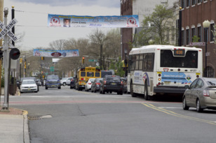
Downtown Freehold at the intersection of West Main Street and Throckmorton Street
|
||
|
||

Location of Freehold Borough in Monmouth County highlighted in yellow (right). Inset map: Location of Monmouth County in New Jersey highlighted in black (left).
|
||

Census Bureau map of Freehold Borough, New Jersey
<mapframe text="Interactive map of Freehold Borough, New Jersey" latitude="40.262862" longitude="-74.277344" zoom="8" width="250" height="250"> { "type": "ExternalData", "service": "geoshape", "ids": "Q691237" } </mapframe> |
||

Freehold Borough, New Jersey
Location in Monmouth County, New Jersey

Freehold Borough, New Jersey
Location in New Jersey

Freehold Borough, New Jersey
Location in the United States
|
||
| Country | ||
| State | ||
| County | Monmouth | |
| Incorporated | March 25, 1869 (as town) | |
| Reincorporated | April 15, 1919 (as borough) | |
| Named for | English legal term of freehold | |
| Government | ||
| • Type | Borough | |
| • Body | Borough Council | |
| Area | ||
| • Total | 1.93 sq mi (5.01 km2) | |
| • Land | 1.93 sq mi (5.00 km2) | |
| • Water | 0.00 sq mi (0.00 km2) 0.10% | |
| Area rank | 419th of 565 in state 32nd of 53 in county |
|
| Elevation | 171 ft (52 m) | |
| Population
(2020)
|
||
| • Total | 12,538 | |
| • Estimate
(2023)
|
12,430 | |
| • Rank | 206th of 565 in state 17th of 53 in county |
|
| • Density | 6,496.4/sq mi (2,508.3/km2) | |
| • Density rank | 82nd of 565 in state 7th of 53 in county |
|
| Time zone | UTC−05:00 (Eastern (EST)) | |
| • Summer (DST) | UTC−04:00 (Eastern (EDT)) | |
| ZIP Code |
07728
|
|
| Area code(s) | 732/848 | |
| FIPS code | 34-25200 | |
| GNIS feature ID | 0885226 | |


Freehold is a small town, or borough, in Monmouth County, New Jersey. It's the main government center for the county. Freehold is famous for its old Victorian houses and rich history from colonial times.
The borough is part of the New York metropolitan area. It is about 33 miles (53 km) from Manhattan. Many people who live here travel to New York City for work. In 2020, Freehold's population was 12,538. This was the highest number of people ever recorded living in the borough.
Freehold Borough and the surrounding Freehold Township are a busy area for business in central New Jersey. The borough is close to many other towns. These include places near the Raritan Bayshore and the Jersey Shore.
Freehold became a town on March 25, 1869. It was formed from parts of Freehold Township. Later, on April 15, 1919, it officially became a borough. The name "Freehold" comes from an old English legal term for owning land completely.
Over the last 40 years, the number of Hispanic and Latino people living in Freehold Borough has grown a lot. In 2020, over half of the population was Hispanic. At the same time, the Black or African American population has become smaller.
History of Freehold Borough
Early Beginnings in Freehold
The first people known to live in the Freehold area were the Lenni Lenape Native Americans. They were hunter-gatherers. This means they hunted small animals and birds, fished, and gathered plants for food. They also grew some crops. An important meeting point of two major Lenape trails was located right where Freehold is today.
By the late 1600s, English settlers started arriving. In 1664, the Duke of York allowed Sir George Carteret to develop the land. In 1685, people from Scotland and New England settled here. They were Presbyterians, Baptists, and Quakers who were looking for religious freedom.
In 1693, Freehold became one of the first three townships in Monmouth County. The name Freehold comes from an English legal term. It describes owning land completely, without owing rent or service to anyone.
Colonial Life in Freehold
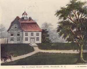
In 1714, the government needed to pick a county seat. This is the main town where the county courthouse is located. John Reid, a Freeholder, sold land in Freehold Township for a very good price. This helped Freehold become the county seat.
The first Monmouth County Courthouse opened in 1715. A small village quickly grew around it. At first, it was called Monmouth Courthouse. More government buildings, homes, and shops soon appeared. These included a blacksmith, a general store, and a hotel.
Farms also grew around Monmouth Courthouse. Freehold farms were known for potatoes, beans, and rye. These crops were sold in nearby cities. Freehold also became famous for its horse farms. The differences between the busy village and the quiet farms eventually led to Freehold splitting into two towns.
By 1745, most families in Freehold were Scottish immigrants. Today, many streets in Freehold are named after these early families.
Freehold During the Revolutionary War

The American Revolution greatly affected Freehold. In the early 1770s, the Sons of Liberty group was active here. They encouraged colonists to resist British rule. In 1775, after the first battles of the war, Captain Elias Longstreet formed the first company of Freehold soldiers. They joined the Continental Army.
Freehold was a known center for American patriots. The Declaration of Independence was read aloud from the steps of the Freehold Courthouse. This happened just days after it was signed in Philadelphia.
However, after a British victory, Freehold and Monmouth County came under the control of Loyalists. These were colonists who supported the British. The British used the Freehold Courthouse. They even arrested some patriots there. But the Continental Army's victory at the Battle of Trenton weakened the Loyalists' power.
In June 1778, the British Army was moving from Philadelphia to New York. On June 28, 1778, the Continental Army met them in Freehold. This led to the Battle of Monmouth. It was one of the biggest battles of the war. Over 25,000 soldiers fought, including American, British, and Hessian troops.
George Washington led the Continental Army. He helped his troops hold their ground. The British managed to complete their main goal, but both sides claimed victory. Many famous people fought in this battle. These included Alexander Hamilton and the Marquis de Lafayette. A famous woman named Molly Pitcher also fought. She took over a cannon after her husband was hurt.
After the battle, Loyalist control in Freehold weakened. The town's government stopped working. The courthouse closed until the war ended. There were small fights between Loyalists and patriots. One famous event was the capture and hanging of Joshua Huddy. He was a patriot leader.
At the end of the war, Freehold was very divided. About 120 Loyalist families left town. They were afraid of being treated badly by their neighbors. Most of them moved to Canada.
Freehold in the 1800s

Freehold grew steadily in the early 1800s. The village around the courthouse became known simply as Freehold. In 1852, a railroad station opened on Throckmorton Street. Trains made regular stops. This helped Freehold grow quickly.
By 1883, Freehold had public sewers, electricity, and telephones. These new technologies brought fast economic growth. Freehold became an important center for business and industry in central New Jersey. Farms also benefited. They could sell their products more easily in New York and Philadelphia.
The American Hotel opened in 1824. It is still standing today and is one of Freehold's oldest buildings. The Freehold Raceway opened in 1853. It is one of America's oldest horse racing tracks. In 1873, a large fire destroyed many wooden buildings, including the courthouse.
Freehold also has a link to bicycle history. Cycling champion Arthur Augustus Zimmerman lived here. He even had his own bicycle company. Today, you can see one of his "Zimmy" bicycles at the Metz Bicycle Museum.
Freehold Splits into Two Towns

By the early 1900s, Freehold was a divided community. People in the downtown area had different ideas about how to spend public money than the farmers outside of town. Tensions grew, especially after a serious polio sickness spread through Freehold in 1916.
After much debate, voters decided to split the town. On April 15, 1919, Freehold Borough officially separated from Freehold Township. People often call them "the Borough" and "the Township." The Borough kept the courthouse and downtown area. The Township, which surrounds the Borough, built a new city hall.
Freehold in the 1900s

Freehold Borough did well at first in the 1900s. But by the middle of the century, downtown areas across the country started to decline. In 1961, the A & M Karagheusian rug factory closed. This was the biggest employer in the area. Its closure hurt the borough's economy.
However, Freehold Borough worked to improve its economy. It made its downtown area a popular spot for restaurants and nightlife. Many local restaurants on Main Street are now very busy.
Freehold Borough was also important for African American civil rights in New Jersey. This was before the Brown v. Board of Education decision in 1954. In 2007, Jaye Sims became the first African American person elected to office here.
Famous rock musician Bruce Springsteen grew up in Freehold Borough. He lived in several homes in town. He graduated from Freehold Borough High School in 1967. Springsteen often mentions Freehold in his songs, like "My Hometown".
Geography of Freehold


Freehold Borough is about 1.93 square miles (5.01 km2) in size. It is located in the middle of Monmouth County. It is about 35 miles (56 km) south of New York City. It is also about 16 miles (26 km) west of Asbury Park on the Jersey Shore.
Freehold is about 174 feet (53 meters) above sea level. Freehold Borough is completely surrounded by Freehold Township. This makes it one of 21 "doughnut towns" in New Jersey. This means one town completely wraps around another.
Freehold's Climate
Freehold Borough is on the edge of two climate zones. It has a mix of a humid subtropical climate and a humid continental climate. This means it has warm, humid summers and cold winters.
| Climate data for Freehold Borough, New Jersey, 1991–2020 normals, extremes 1893–present | |||||||||||||
|---|---|---|---|---|---|---|---|---|---|---|---|---|---|
| Month | Jan | Feb | Mar | Apr | May | Jun | Jul | Aug | Sep | Oct | Nov | Dec | Year |
| Record high °F (°C) | 73 (23) |
79 (26) |
87 (31) |
95 (35) |
96 (36) |
100 (38) |
106 (41) |
102 (39) |
99 (37) |
95 (35) |
83 (28) |
76 (24) |
106 (41) |
| Mean daily maximum °F (°C) | 41.7 (5.4) |
44.4 (6.9) |
51.4 (10.8) |
63.0 (17.2) |
72.0 (22.2) |
81.1 (27.3) |
86.5 (30.3) |
84.6 (29.2) |
78.1 (25.6) |
66.6 (19.2) |
56.2 (13.4) |
46.7 (8.2) |
64.4 (18.0) |
| Daily mean °F (°C) | 32.3 (0.2) |
34.7 (1.5) |
41.4 (5.2) |
52.1 (11.2) |
61.3 (16.3) |
70.6 (21.4) |
76.0 (24.4) |
74.0 (23.3) |
67.1 (19.5) |
55.5 (13.1) |
45.9 (7.7) |
37.4 (3.0) |
54.0 (12.2) |
| Mean daily minimum °F (°C) | 22.9 (−5.1) |
25.0 (−3.9) |
31.3 (−0.4) |
41.2 (5.1) |
50.6 (10.3) |
60.1 (15.6) |
65.5 (18.6) |
63.4 (17.4) |
56.1 (13.4) |
44.3 (6.8) |
35.7 (2.1) |
28.0 (−2.2) |
43.7 (6.5) |
| Record low °F (°C) | −14 (−26) |
−20 (−29) |
−2 (−19) |
17 (−8) |
28 (−2) |
35 (2) |
42 (6) |
41 (5) |
32 (0) |
20 (−7) |
7 (−14) |
−5 (−21) |
−20 (−29) |
| Average precipitation inches (mm) | 3.87 (98) |
3.10 (79) |
4.20 (107) |
3.83 (97) |
3.81 (97) |
4.44 (113) |
4.65 (118) |
4.13 (105) |
4.19 (106) |
4.13 (105) |
3.54 (90) |
4.68 (119) |
48.57 (1,234) |
| Average precipitation days (≥ 0.01 in) | 10.7 | 9.2 | 9.9 | 11.6 | 12.5 | 11.8 | 9.8 | 10.7 | 9.1 | 10.2 | 9.4 | 10.1 | 125.0 |
| Source: NOAA | |||||||||||||
Local Ecology
Freehold Borough's natural plant life would mostly be Oak trees. It would also have an Eastern Hardwood Forest.
People of Freehold

Freehold Borough is home to a diverse group of people. In 2010, there were 12,052 residents. The population included people of different backgrounds. About 65.7% were White, 12.6% Black or African American, and 2.9% Asian. Many people were also from other races.
A large part of the population, 42.9%, was Hispanic or Latino. This group has grown a lot in recent years.

The average household in Freehold had about 3 people. About a third of households had children under 18. The median age of residents was 33.3 years old. This means half the people were younger than 33.3 and half were older.
Economy and Business
Freehold is a popular place for shopping and business in Central New Jersey. This is because it's close to the Jersey Shore and big cities like New York City, Newark, and Philadelphia.
Shopping and Downtown Life
Main Street Businesses

Downtown Freehold is on East and West Main Street. It has many restaurants, cafes, shops, and historical places. There are plans to make the downtown area even better. One idea is to turn the Freehold Center Bus Station into a "Transit Village." This would create new development around the bus station.
Freehold Raceway

Freehold Raceway opened in 1853. It is the oldest half-mile horse racing track in the country. Horse lovers can watch harness racing here. However, the raceway announced it will close on December 28, 2024.
Freehold Raceway Mall
The Freehold Raceway Mall is a very large shopping mall. It opened in 1990. It is located in Freehold Township, right across from the Freehold Raceway. The mall has many stores and covers a huge area.
Manufacturing History

Freehold Borough and Township grew with factories in the late 1800s and early 1900s.
A and M Karagheusian Rug Mill
A & M Karagheusian was a rug factory in Freehold Borough. It operated for 60 years. At its busiest in the 1930s, it employed 1,700 people. The factory closed in 1964.
Bruce Springsteen wrote about the factory's closing in his 1984 song "My Hometown". The old factory building is now used for affordable housing.
Other Factories
Brockway Glass Company built a factory in Freehold in 1955. It closed in 1991. Today, the site is used by Iron Mountain, a company that manages information. Nestle also had a production plant in Freehold that opened in 1948 and closed in 2023.
Parks and Fun Activities
.jpg)

The Freehold area has many natural spaces for outdoor fun. These include Monmouth Battlefield State Park, Turkey Swamp Park, and Lake Topanemus.
Smaller parks in Freehold Borough are managed by the Borough Recreation Commission. These include Liberty Park, Veterans Park, and Vinyard Park.
The southern part of the Henry Hudson Trail starts in Freehold Borough. This trail follows an old railroad line. It is used by walkers, runners, and bicyclists.
Lake Topanemus is a 71-acre (29 ha) park. It is in Freehold Township but owned by the borough. You can go freshwater fishing, paddle boating, and canoeing there. The park also has pretty nature trails, playgrounds, and open fields.
Education in Freehold

Students in Freehold Borough attend public schools from pre-kindergarten through eighth grade. These schools are part of the Freehold Borough Schools district. There are three schools:
- Freehold Learning Center (PreK–2)
- Park Avenue Elementary School (grades 3–5)
- Freehold Intermediate School (grades 6–8)
For high school, students go to Freehold High School. This school is part of the Freehold Regional High School District (FRHSD). This district serves students from several nearby towns. Freehold High School also has a special program called the Medical Sciences Learning Center.
The Freehold Public Library is a special library. It was built in 1904 with money from Andrew Carnegie. It is one of the few libraries left in New Jersey that still has "Carnegie Library" carved on its front. It is not part of the county library system.
Transportation and Roads
Roads and Highways
_in_Freehold,_Monmouth_County,_New_Jersey.jpg)
_at_the_exit_for_Monmouth_County_Route_537_EAST_in_Freehold,_Monmouth_County,_New_Jersey.jpg)
Freehold Borough has over 31 miles (50 km) of roads. Major roads that pass through Freehold Borough include:
- U.S. Route 9
- Route 33 Business
- Route 79
- County Route 522
- County Route 537
Freehold Circle
The Freehold Circle was once a large traffic circle. It was near the Freehold Raceway. It connected U.S. Route 9 and other routes. In the 1980s, it was changed to handle more traffic. Now it has several special turns called "jughandles." Locals still call it Freehold Circle.
Public Transportation
Train Service
In the past, Freehold had two major railways. The Freehold and Jamesburg Agricultural Railroad opened in 1853. It made Freehold a transportation hub. The Central Railroad of New Jersey also had a line here.
These old train lines are mostly gone now. Some parts have become walking trails, like the Henry Hudson Trail. Freehold's old train station is now the central bus station.
There is a plan called the Monmouth Ocean Middlesex Line. It proposes to bring passenger train service back to the area. Freehold Borough could be a stop on this new line.
For now, the closest train stations are in towns like Aberdeen-Matawan and Asbury Park.
Proposed NJ Transit Village
Freehold Borough wants to improve its downtown area. NJ Transit is helping with a project to make the Freehold Center Bus Station a "Transit Village." This means creating a special area around the bus station. It would encourage new buildings and businesses that are easy to reach by public transport.
The borough council is working to move the current municipal complex. This would open up more space for new development in the "Transit Village" area.
Bus Service

NJ Transit buses connect Freehold to many places. You can take a bus to Newark Liberty International Airport or New York City. Buses also go to Six Flags Great Adventure. Local bus routes serve the area too.
Healthcare in Freehold
Freehold Borough has healthcare services from CentraState Healthcare System. This is a hospital in Freehold Township. It has 287 beds. CentraState also has family doctor offices in nearby towns. It is one of the largest employers in Monmouth County.
Other hospitals close to Freehold include Bayshore Community Hospital and Raritan Bay Medical Center.
Places to Visit in Freehold
- Freehold Public Library: A historic library built with money from Andrew Carnegie.
- Monmouth County Historical Association: A museum and library about Monmouth County's history.
- Freehold Raceway: The oldest horse racing track in the United States.
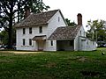
- Hankinson-Moreau-Covenhoven House: A house built in the 1750s. The British used it as a headquarters during the Battle of Monmouth.
- St. Peter's Episcopal Church: A church built in 1771. It is one of the oldest churches still standing in New Jersey.
- Freehold Jewish Center: A synagogue established in 1911.
- Metz Bicycle Museum: Shows old bicycles from the 1850s.
- Monmouth County Courthouse and Battle of Monmouth Monument: Important historical sites.
Notable People from Freehold
Many interesting people have lived in or are connected to Freehold Borough:
- Scott Conover (born 1968): A former football player for the Detroit Lions. He also wrote a children's book.
- Anthony DeSclafani (born 1990): A pitcher for the San Francisco Giants baseball team.
- Robert Griswold (born 1996): A swimmer.
- Danny Lewis (1936–2015): A former NFL football player.
- Joel Parker (1816–1888): He was the 20th Governor of New Jersey twice.
- Tim Perry (born 1965): A former NBA basketball player.
- Darrell Reid (born 1982): A former defensive tackle for the Denver Broncos and Indianapolis Colts football teams.
- J. R. Smith (born 1985): A professional basketball player.
- Rebecca Soni (born 1987): An Olympic gold medalist swimmer. She set world records in breaststroke.
- Bruce Springsteen (born 1949): A famous rock musician. He grew up in Freehold Borough. His song "My Hometown" is about the town.
Images for kids
-
Covenhoven House, 2012
-
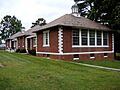
Court Street School, 2012
-
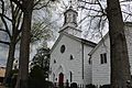
St. Peter's Episcopal Church, 2021
-
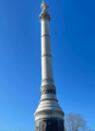
Monument dedicated to the Battle of Monmouth, located on the premises for the Monmouth County Courthouse, 2021


.jpg)

See also
 In Spanish: Freehold (Nueva Jersey) para niños
