
Fulton County, New York facts for kids
Quick facts for kids
Fulton County
|
|||
|---|---|---|---|

Fulton County Courthouse
|
|||
|
|||

Location within the U.S. state of New York
|
|||
 New York's location within the U.S. |
|||
| Country | |||
| State | |||
| Founded | 1838 | ||
| Named for | Robert Fulton | ||
| Seat | Johnstown | ||
| Largest city | Gloversville | ||
| Area | |||
| • Total | 533 sq mi (1,380 km2) | ||
| • Land | 495 sq mi (1,280 km2) | ||
| • Water | 37 sq mi (100 km2) 7.0% | ||
| Population
(2020)
|
|||
| • Total | 53,324 | ||
| • Density | 107.6/sq mi (41.5/km2) | ||
| Time zone | UTC−5 (Eastern) | ||
| • Summer (DST) | UTC−4 (EDT) | ||
| Congressional district | 21st | ||


Fulton County is a county in the U.S. state of New York. It is part of the state's Mohawk Valley region. The main town, or county seat, is Johnstown.
In 2020, about 53,324 people lived in Fulton County. The county is named after Robert Fulton. He is famous for creating the first successful steamboat.
Contents
History of Fulton County
Fulton County was formed in 1838. It was created from a part of Montgomery County. This happened after Montgomery County's main town moved to Fonda.
A lawyer named Daniel Cady helped create Fulton County. His wife was a relative of Robert Fulton, who the county is named after. When it was formed, Fulton County covered about 550 square miles.
The old courthouse in Johnstown was built in 1772. It was first the Tryon County courthouse, then Montgomery County's. Today, it is the Fulton County Courthouse. It is New York's oldest courthouse still in use.
In 1860, a small piece of land (about 10 square miles) was moved from Fulton County to Hamilton County. This created the borders of Fulton County as we know them today.
Early Settlers and Industry
In the mid-1700s, Sir William Johnson came to this area. He was an Irish pioneer and army officer. He also founded Fort Johnson and Johnstown. Sir William Johnson was in charge of British relations with Native American tribes from 1755 to 1774. His homes, Fort Johnson and Johnson Hall, are now New York State Historic Sites.
Fulton County was also home to Elizabeth Cady Stanton. She was a very important leader in the women's rights movement in America.
After the American Revolutionary War, making gloves and leather became the main business here. At one time, Johnstown and Gloversville were known as the "Glove and Leather Capital of the World." Many people moved to the area because of these successful businesses.
Today, fewer people work as glovers or tanners. However, some companies have changed to stay strong in the market. Many people in Fulton County can still trace their family history back to the glove and leather trades.
Geography of Fulton County
Fulton County covers about 533 square miles. About 495 square miles are land, and 37 square miles (7%) are water. The county is in the central part of New York State. It is northwest of Albany.
The county is located in the southern part of the Adirondack Mountains. About 58% of Fulton County is inside the Adirondack Park. This park is a large protected area.
Neighboring Counties
Fulton County shares borders with these other counties:
- Hamilton County - to the north
- Saratoga County - to the east
- Montgomery County - to the south
- Herkimer County - to the west
Population and People
In 2020, Fulton County had a population of 53,324 people. Most residents are white. There are also Black or African American, Native American, Asian American, and multiracial people. About 4% of the population is Hispanic or Latino.
Most households in Fulton County own their homes. The average household has about 2 to 3 people. About 13% of the county's population lives below the poverty line.
Transportation
Fulton County has two public airports and several private airstrips.
- Fulton County Airport (NY0) – in Johnstown
- Dolgeville Airport (1F6) – in Dolgeville
The Gloversville Transit System provides bus service. It connects parts of Fulton County with nearby Montgomery County. The county's Highways and Facilities Department takes care of roads. They build, repair, and clear snow from roads. Each town and village also has its own road department.
Main Roads
 New York State Route 10
 New York State Route 10A
 New York State Route 29
 New York State Route 29A
 New York State Route 30
 New York State Route 30A
 New York State Route 67
 New York State Route 309
 New York State Route 331
 New York State Route 334
 New York State Route 349
- New York State Route 399
- List of county routes in Fulton County, New York
Communities in Fulton County
Cities
- Gloversville
- Johnstown (This is the county seat, or main town)
Towns
Villages
Other Places
- Caroga Lake (a census-designated place)
- Kingsboro (a small community)
Education in Fulton County
In 2019, about 87% of people in Fulton County had a high school degree or higher. Nearly 18% had a college degree.
Fulton–Montgomery Community College is located in Johnstown. It is part of the State University of New York system.
School Districts
- Amsterdam City School District
- Broadalbin-Perth Central School District
- Dolgeville Central School District
- Edinburg Common School District
- Fonda-Fultonville Central School District
- Fort Plain Central School District
- Galway Central School District
- Gloversville City School District
- Johnstown City School District
- Mayfield Central School District
- Northville Central School District
- Oppenheim-Ephratah-St. Johnsville Central School District
- Wheelerville Union Free School District
Images for kids
-
The flag of Fulton County, New York.
-
The seal of Fulton County.
-
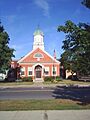
The Fulton County Courthouse.
See also
 In Spanish: Condado de Fulton (Nueva York) para niños
