
Gaborone facts for kids
Quick facts for kids
Gaborone
|
||
|---|---|---|
     Top: Gaborone CBD; Middle: Botswana Parliament, Ministry of Education Building; Bottom: Gaborone National Museum, Botswana National Archives and Records Services
|
||
|
||
| Nicknames:
Gabs, GC, Gabz, G-City, Mageba, Moshate
|
||

Gaborone
Location in Botswana

Gaborone
Location in Africa
|
||
| Country | ||
| District | South East | |
| Sub-district | Gaborone | |
| Founded | 1964 | |
| Named for | Kgosi Gaborone | |
| Government | ||
| • Type | City commission government | |
| • Body | Gaborone City Council | |
| Area | ||
| • Capital city | 169 km2 (65.25 sq mi) | |
| Elevation | 1,014 m (3,326 ft) | |
| Population
(2022)
|
||
| • Capital city | 246,325 | |
| • Estimate
(2020)
|
273,602 | |
| • Density | 1,458/km2 (3,775.10/sq mi) | |
| • Metro | 421,907 | |
| Time zone | UTC+02:00 (Central Africa Time) | |
| • Summer (DST) | (Not Observed) | |
| Geographical area code | 3XX | |
| ISO 3166 code | BW-SE | |
| HDI (2019) | 0.820 very high |
|
| Website | Gaborone City Council Website | |

Gaborone is the capital and largest city of Botswana. In 2022, about 246,325 people lived there. This is about 10% of Botswana's total population. The larger area around Gaborone is home to over 421,907 people. Gaborone has the highest income per person in Africa.
The city is located in the south-eastern part of Botswana. It sits between Kgale Hill and Oodi Hill. It is also near where the Notwane River and Segoditshane River meet. Gaborone is only about 15 kilometers (9 miles) from the South African border. The Sir Seretse Khama International Airport serves the city. Gaborone is its own administrative district. It is also the capital of the nearby South-East District. People often call the city GC or Motse-Mshate.
Gaborone is named after Chief Gaborone of the Tlokwa tribe. He used to control land nearby. The city was chosen as the capital in the mid-1960s. This was when the Bechuanaland Protectorate became an independent country. It was picked because it had no tribal ties and was close to fresh water. The city's center has a long street of shops called "Main Mall". East of this, there is a semicircle of government offices. Gaborone grew very fast, which caused problems with housing. In the 1980s, the city also faced issues from conflicts in Zimbabwe and South Africa.
Gaborone is important for both the government and the economy. Many companies have their main offices here. The Botswana Stock Exchange is also in Gaborone. The city is home to the Southern African Development Community (SADC). This group works to improve economic cooperation in Southern Africa. Many languages are spoken in Gaborone. The main language is Setswana (Tswana). English, Kalanga, and Kgalagadi are also spoken.
Contents
- History of Gaborone
- Geography and Location
- People of Gaborone
- Culture and Arts
- Economy and Business
- Sports and Recreation
- Education and Learning
- Media and Communication
- City Infrastructure
- Healthcare Services
- Transportation in Gaborone
- Notable People from Gaborone
- International Connections
- Images for kids
- See also
History of Gaborone


People have lived along the Notwane River for hundreds of years. Around 1880, the Tlokwa tribe settled in the area. They called their settlement Moshaweng. The name "Gaborone" means "it does not fit badly". Early European settlers called the city "Gaberones". This was a shorter way of saying "Gaborone's Village". It was named after Chief Gaborone of the Tlokwa tribe. His village was across the river from the colonial government's headquarters, called Government Camp. The nickname "GC" comes from "Government Camp".
In 1890, Cecil John Rhodes chose Gaberones for a colonial fort. This fort was where Rhodes planned the Jameson Raid. The city's name changed from Gaberones to Gaborone in 1969.
The modern city was started in 1964. This was after the decision to create a capital for Botswana. Botswana became a self-governing area in 1965. It then became a fully independent country on September 30, 1966.
In 1965, the capital of the Bechuanaland Protectorate moved from Mafeking to Gaberones. At first, Lobatse was considered for the capital. But Lobatse was too small. So, a new capital city was built next to Gaberones. The new location was chosen for several reasons. It had fresh water and was close to the railway to Pretoria. It was also central to the main tribes and had no ties to them.
The city was planned using Garden City principles. This meant it had many walking paths and open spaces. Building Gaborone began in mid-1964. The city's layout was compared to a "brandy glass". Government offices were at the base, and businesses were in the "mall" area.
Most of the city was built quickly, in about three years. It was designed for 20,000 people. But it grew much larger after independence. Early buildings included government offices, a hospital, schools, and over 1,000 houses. Because of the fast building, many workers came. Some built illegal settlements, like Naledi. In 1971, the city council planned low-income housing in Bontleng. But Naledi kept growing. In 1975, President Seretse Khama changed Naledi from an industrial area to a housing area.
On September 30, 1966, Bechuanaland became independent. Reverend Derek Jones was the first mayor of Gaborone. The old Gaberones became a part of the new Gaborone. It is now known as "the Village".
In the mid-1980s, South Africa attacked Botswana. They raided Gaborone and other border towns. The Raid on Gaborone caused twelve deaths.
After the 1994 General Elections, riots happened in Gaborone. This was due to high unemployment and other problems.
Today, Gaborone is still growing very fast. In 1964, it had only 3,855 people. By 1992, it had 138,000 people. This rapid growth has led to many informal settlements.
Geography and Location


Gaborone is located at 24°39′29″S 25°54′44″E / 24.65806°S 25.91222°E. It sits between Kgale and Oodi Hills. The city is in the south-eastern part of Botswana, near the Notwane River. It is about 15 kilometers (9 miles) from the South African border. Gaborone is about 1,010 meters (3,314 feet) above sea level.
Cities near Gaborone include Ramotswa to the southwest and Mogoditshane to the northwest. Mochudi is to the east, and Tlokweng is across the river. Many of these are towns where people live and then travel to Gaborone for work. Some areas within Gaborone are Broadhurst, Gaborone West, The Village, and Naledi. Phakalane, a wealthy area, is about 13 km (8 miles) north of the city center.
The Main Mall is in the center of the city. Many foreign offices are located here. At the eastern end of the Mall, you can find the Civic Centre. There is also the Pula Arch, which celebrates Botswana's independence. The Botswana Stock Exchange, National Museum and Art Gallery, and the University of Botswana are also near the Main Mall. West of the Main Mall is the Government Enclave. This area has government buildings like the National Assembly of Botswana. The National Archives building is also here.
 |
Mogoditshane, Molepolole | Dumadumana, Kopong, Lentsweletau | Tlokweng, Pilane, Mochudi | |
| Gabane, Thamaga | Modipane, Sikwane | |||
| Kanye | Ramotswa, Otse, Lobatse |
Gaborone's Climate
Gaborone has a hot, dry climate. Most of the year, it is very sunny. Summers are usually hot, and nights are cool. If there is little rain, the hottest temperatures are in January or February. If there is normal rain, the hottest temperatures are in October, before the rainy season. Winters have warm days and cold nights.
On average, there are 74 days a year with temperatures above 32°C (90°F). There are 196 days a year with temperatures above 26°C (79°F). Temperatures drop below 7°C (45°F) about 51 days a year. It rarely goes below 0°C (32°F). The highest temperature ever recorded was 43.9°C (111°F). The lowest was -6.5°C (20°F).
Rainfall in Gaborone is not much and can be unpredictable. Most rain falls in the summer, from October to April. There are about 40 thunderstorms a year, mostly in summer. Fog happens about four days a year, usually in winter. Gaborone has had three floods since 1995.
| Climate data for Gaborone (Sir Seretse Khama Airport, 1981–2010) | |||||||||||||
|---|---|---|---|---|---|---|---|---|---|---|---|---|---|
| Month | Jan | Feb | Mar | Apr | May | Jun | Jul | Aug | Sep | Oct | Nov | Dec | Year |
| Record high °C (°F) | 39 (103) |
40.6 (105.1) |
39 (102) |
37 (98) |
33 (91) |
29 (84) |
28 (83) |
33 (91) |
39 (103) |
38 (100) |
40 (104) |
39 (103) |
40 (104) |
| Mean daily maximum °C (°F) | 32.7 (90.9) |
32.1 (89.8) |
30.8 (87.4) |
28.4 (83.1) |
25.6 (78.1) |
23.1 (73.6) |
22.9 (73.2) |
26.2 (79.2) |
30.0 (86.0) |
32.0 (89.6) |
32.3 (90.1) |
32.5 (90.5) |
29.1 (84.4) |
| Daily mean °C (°F) | 25.7 (78.3) |
25.2 (77.4) |
23.7 (74.7) |
20.6 (69.1) |
16.8 (62.2) |
13.7 (56.7) |
13.5 (56.3) |
16.9 (62.4) |
21.2 (70.2) |
24.0 (75.2) |
24.7 (76.5) |
25.3 (77.5) |
20.9 (69.6) |
| Mean daily minimum °C (°F) | 19.7 (67.5) |
19.3 (66.7) |
17.4 (63.3) |
13.5 (56.3) |
8.3 (46.9) |
5.0 (41.0) |
4.4 (39.9) |
7.5 (45.5) |
12.3 (54.1) |
16.3 (61.3) |
17.7 (63.9) |
18.8 (65.8) |
13.4 (56.1) |
| Record low °C (°F) | 14 (57) |
13 (55) |
11 (52) |
0 (32) |
−1 (30) |
−1 (30) |
−2 (28) |
0 (32) |
5 (41) |
7 (45) |
8 (46) |
11 (52) |
−2 (28) |
| Average precipitation mm (inches) | 143 (5.6) |
82 (3.2) |
74 (2.9) |
30 (1.2) |
8.3 (0.33) |
7.5 (0.30) |
1 (0.0) |
0.9 (0.04) |
5.8 (0.23) |
5.8 (0.23) |
58 (2.3) |
71 (2.8) |
487.3 (19.13) |
| Average rainy days | 6 | 5 | 5 | 3 | 2 | 1 | 1 | 1 | 2 | 4 | 5 | 6 | 41 |
| Source 1: African Regional Climate Centre | |||||||||||||
| Source 2: Weatherbase (records) | |||||||||||||
People of Gaborone
| Historical population | ||
|---|---|---|
| Year | Pop. | ±% p.a. |
| 1964 | 3,855 | — |
| 1971 | 17,718 | +24.34% |
| 1981 | 59,657 | +12.91% |
| 1991 | 133,468 | +8.39% |
| 2001 | 186,007 | +3.37% |
| 2006 | 191,776 | +0.61% |
| 2011 | 231,626 | +3.85% |
| 2022 | 246,325 | +0.56% |
| Sources: | ||
In 2022, Gaborone had 246,325 people. There were 118,727 males and 127,598 females. The city has 58,476 households. In 2001, the average household had 3.11 people. More than 10% of Botswana's population lives in Gaborone. Almost half of all Botswana citizens live within 100 kilometers (62 miles) of Gaborone.
Gaborone's population is growing fast, at 3.4% per year. This is the highest rate in the country. Many people move to Gaborone because it has better services and facilities.
Places of Worship

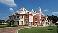
Gaborone has many places of worship. Most are Christian churches. These include churches from the Evangelical Lutheran Church in Botswana, Assemblies of God, and the Roman Catholic Diocese of Gaborone. There are also two Serbian Orthodox churches.
Culture and Arts
The National Museum and Art Gallery is located near the Main Mall. It opened in 1968. The museum displays traditional crafts and art by local artists. It also has paintings by Thomas Baines and Lucas Sithole. Outside, you can see old forms of transportation. There is also an exhibit about the San people, who were the first people in southern Africa. In 2007, the museum opened the National Botanical Garden. This garden helps protect Botswana's native plants.
The Maitisong Festival started in 1987. It happens every year for seven days in late March or early April. The festival features outdoor concerts, plays, and films.
"My African Dream" was a performing arts competition. It was held every year at the Gaborone International Convention Center. The show featured many dancers and musicians.
The book series The No. 1 Ladies' Detective Agency is set in Gaborone. It was written by Scottish author Alexander McCall Smith. The books are about Precious Ramotswe, Botswana's first female private detective. The Detective Kubu series, by Michael Stanley, also takes place in Gaborone. It features Detective David 'Kubu' Bengu.
Economy and Business

Gaborone is the center of Botswana's economy. Important financial groups have their main offices here. These include the Bank of Botswana and the Botswana Stock Exchange. Other companies like Air Botswana and Debswana (a diamond mining company) are also based here.
The Southern African Development Community (SADC) has its headquarters in Gaborone. This group was formed in 1980. It works to improve economic cooperation among its members. Many international companies have also invested in Gaborone. These include Hyundai, SABMiller, and Siemens.
.jpg)
Orapa House is owned by Debswana. This is where diamonds from Debswana mines are sorted and valued. Its unique design allows natural light to help in sorting diamonds.
A Diamond Technology Park recently opened in Gaborone. This is part of Botswana's plan to develop its diamond industry. Companies that work with diamonds have set up their businesses here.
The Botswana Resource Conference is held every year at the Gaborone International Conference Centre.
The cost of living in Gaborone is lower than in many other cities for people from other countries.
Sports and Recreation
Gaborone has several football stadiums. These include SSKB Stadium and Botswana National Stadium. Many football teams from Gaborone play in the Botswana Premier League. The Botswana national football team plays at the National Stadium.
The Botswana Cricket Association is based in Gaborone. There are two cricket fields in the city.
The Steinmetz Gaborone Marathon started in 2010. It is held every year. The race begins at the Phakalane Golf Estate and goes through Gaborone.
| Botswana Cricket Association Oval | Cricket | n/a | Botswana cricket team |
| Botswana National Stadium | Football, athletics, rugby, tennis | 25,000 | Gaborone United, Notwane F.C., Police XI, Township Rollers F.C. |
| Mochudi Stadium | Football | 10,000 | Mochudi Centre Chiefs |
| SSKB Stadium | Football | 5,000 | Botswana Defence Force XI |
| University of Botswana Stadium | Football | 5,000 | Uniao Flamengo Santos F.C. |
Parks and Nature
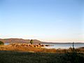
The Gaborone Dam is south of the city. It provides water for Gaborone and Lobatse. It is the second largest dam in Botswana. The dam is also becoming a popular place for fun activities. The northern part is planned to be an entertainment area called The Waterfront. There is a yacht club there. The southern part has the Kalahari Fishing Club and City Scapes. City Scapes has parks, playgrounds, and boating areas. The dam is great for birdwatching, windsurfing, and fishing. However, swimming is not allowed because of crocodiles and parasites.

The Gaborone Game Reserve is a 600-hectare (1,500-acre) park east of the city. It was built in 1988. You can see animals like impala, kudu, ostriches, wildebeest, and zebras here. It is also a good place for birdwatching.

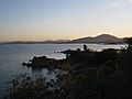
Kgale Hill is very close to the city. It is called the Sleeping Giant and is 1,287 meters (4,222 feet) tall. There are three paths to reach the top, usually taking two hours.
The Mokolodi Nature Reserve is a 30-square-kilometer (12-square-mile) reserve. It was created in 1994 and is 12 kilometers (7 miles) south of Gaborone. Many animals live here, such as common warthogs, giraffes, hippos, and rhinos. The park helps with wildlife projects, like bringing back the white rhino. Mokolodi also has an Education Centre that teaches children about protecting nature.
Somarelang Tikologo (Environment Watch Botswana) is an environmental group. It is located in an ecological park in Gaborone. The group teaches people about protecting the environment. The park has a playground, an organic garden, and a recycling center.
Education and Learning

More people in Gaborone have college degrees than anywhere else in Botswana. About 70.9% of Gaborone's population has at least a secondary school education. Only 2.6% of people in Gaborone have never been to school.
Gaborone has many schools, both public and private. Some well-known schools include Westwood International School, Maru-a-Pula School, and St. Joseph's College, Kgale.
The main campus of the University of Botswana is in the eastern part of the city. It was started in 1982. There are also other universities and colleges for special studies:
- Limkokwing University Of Creative Technology
- Botswana Accountancy College
- Botswana Open University (for distance learning)
- Gaborone Technical College
- Botho University
- Botswana University of Agriculture and Natural Resources
In 2006, the Gaborone Universal College of Law opened its main campus.
Media and Communication
Newspapers published in Gaborone include Mmegi, The Botswana Gazette, and The Voice. Magazines like Lapologa and Peolwane are also published here.
Radio stations like Yarona FM and Gabz FM broadcast from Gaborone. About 86.6% of homes in Gaborone have a radio.
Today, the Gaborone Broadcasting Company and Botswana TV provide television programs. About 78.7% of homes in Gaborone have a TV. Other local channels include Now TV and Maru TV.
Most homes in Gaborone, about 93.7%, have a cell phone.
City Infrastructure

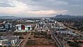
Gaborone is one of the fastest-growing cities in Africa. Its growth has caused nearby farmland to become part of the city. Most of Gaborone's food comes from the north of the city.
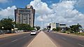
The city center was planned to be very practical and modern. The main business area (CBD) is still being built. When people say downtown, they usually mean the Main Mall and Government Enclave. These areas have tall buildings. The Main Mall is a shopping area where cars are not allowed. It runs from east to west. The Government Enclave and National Assembly are on the west side. The Gaborone City Town Council is on the east.
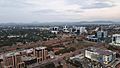
Gaborone's CBD has new buildings like the Square Mall and The Tower. It also has the new SADC headquarters. The Three Dikgosi Monument is a famous landmark here. It has statues of three important chiefs: Khama III, Sebele I, and Bathoen I. They traveled to Great Britain to protect Bechuanaland.
City Utilities
Gaborone gets most of its water from the Gaborone Dam. This dam is on the southeast side of the city. It was built to provide water for all the city's people.
From 2007 to 2008, Gaborone sold 23,963,000 cubic meters (31,340,000 cubic yards) of water. The government used the most water. Homes used 8,564,000 cubic meters (11,200,000 cubic yards). Businesses used 4,040,000 cubic meters (5,280,000 cubic yards). Gaborone has some of the highest water prices in the country. This is because it costs a lot to transport water, and some water comes from the Letsibogo Dam.
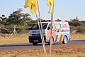
Healthcare Services
.jpg)
The Botswana Red Cross Society is based in Gaborone. It was started in 1968. The Princess Marina Hospital is the main hospital in Gaborone. It has 500 beds.
There are also private hospitals like Gaborone Private Hospital and Sidilega Private Hospital. The Cancer Association of Botswana is a non-profit group that helps people with cancer.
Transportation in Gaborone
Railways
The railway line runs through the city from north to south. It is still very important. Botswana Railways has a line that connects Cape Town to Harare. The railway station in Gaborone is south of the Parliament House. The line stops at several cities in and near Botswana. Passenger services on this line started again in early 2016.
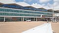
Airports

Sir Seretse Khama International Airport (GBE) is about 25 kilometers (16 miles) north of the city. In 2018, it had flights to Cape Town, Johannesburg, Durban, and Addis Ababa. It also has flights to other places within Botswana. It is the main base for Air Botswana, the national airline.
In 2008, the airport handled 15,844 aircraft movements. Gaborone has the most air passenger traffic in Botswana. The airport terminal was rebuilt in 2010 to be more modern.
Roads
Major roads in and around Gaborone include the Trans-Kalahari Highway and the A1 Highway. There are five main roads from Gaborone that lead to other towns like Lobatse, Kanye, and Francistown.
Public Transport

Public transport in Gaborone is generally good. Kombis (small vans) and taxis operate within the city. Buses connect Gaborone to nearby villages and other towns in Botswana.
Private Vehicles
Gaborone has several places where vehicles can be registered. In 2008, 15,538 new private vehicles were registered in Gaborone. This was 46.5% of all new vehicle registrations in Botswana. Most of these were passenger cars.
In 2008, Gaborone had 9,415 vehicle accidents. Most accidents involved pedestrians. Most traffic accidents happen between 4 PM and 6 PM.
Notable People from Gaborone
- Letsile Tebogo (born 2003) is an athlete from Botswana. He won silver and bronze medals at the 2023 World Championships. He was the first African man to win a medal in the 100m race.
- Kgosi Gaborone (around 1825–1931), a chief after whom the city is named.
- Alec Campbell (1932–2012), an archaeologist and museum curator.
- Mpule Kwelagobe (born 1979), who was Miss Universe 1999.
- Donald Molosi (born 1985), an actor, writer, and playwright.
- Emma Wareus (born 1990), who was first runner-up to Miss World 2010.
International Connections
Gaborone is a sister city with:
Images for kids
-
Flag map of Gaborone
-
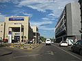
Street scene near the Main Mall
-
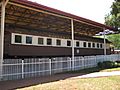
Rhodesia Railways car at the national museum
-
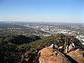
View from Kgale Hill (Oodi Hill on horizon)
-
Gaborone Dam
-
Gaborone Dam
-
Botswana Gaborone I Towers
-
Gaborone Hindu Temple
-
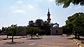
Gaborone Mosque
-
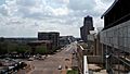
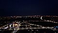
CBD
-
CBD Developments
-
New Construction Developments
-
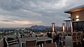
Room 52 Roof Top Restaurant
-
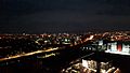
New CBD
-
Christ The King Cathedral
-
CBD Mall
-
SSKI Airport
-
Medical rescue team car


See also
 In Spanish: Gaborone para niños
