Garfield County, Washington facts for kids
Quick facts for kids
Garfield County
|
|
|---|---|

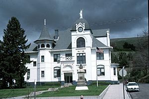
Garfield County Courthouse in Pomeroy
|
|

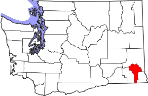
Location within the U.S. state of Washington
|
|
 Washington's location within the U.S. |
|
| Country | |
| State | |
| Founded | November 29, 1881 |
| Named for | James A. Garfield |
| Seat | Pomeroy |
| Largest city | Pomeroy |
| Area | |
| • Total | 718 sq mi (1,860 km2) |
| • Land | 711 sq mi (1,840 km2) |
| • Water | 7.5 sq mi (19 km2) 1.0%% |
| Population
(2020)
|
|
| • Total | 2,286 |
| • Estimate
(2023)
|
2,363 |
| • Density | 3.1/sq mi (1.2/km2) |
| Time zone | UTC−8 (Pacific) |
| • Summer (DST) | UTC−7 (PDT) |
| Congressional district | 5th |
Garfield County is a county located in the U.S. state of Washington. As of the 2020 census, it had 2,286 people. This makes it the least populated county in Washington. It is also the least densely populated county. The main city and county seat is Pomeroy.
Contents
History of Garfield County
The area that is now Washington state began to be settled in the early 1800s. Both Americans and British people were interested in the land. The British mainly wanted furs, while American settlers looked for land to farm and raise cattle.
For a while, the region was under shared control by both countries. This was called a condominium. It led to many disagreements. In 1846, a treaty was signed to end this shared control. This treaty set the border between what is now Canada and the United States.
In 1854, Walla Walla County was created from Skamania County. Later, in 1875, Columbia County was formed from Walla Walla County. On November 29, 1881, a part of Columbia County became Garfield County.
A few years later, in 1883, Garfield County became a bit smaller. Its southeastern part was used to create Asotin County. Garfield County was named after James A. Garfield, who was the U.S. President. He had been assassinated just a few weeks before the county was formed.
Geography of Garfield County
Garfield County covers about 718 square miles (1,860 square kilometers). Most of this area is land, with a small amount of water. The county is part of the Palouse. This is a wide, rolling area of hills in the middle of the Columbia River basin.
Important Geographic Features
Main Roads
Neighboring Counties
- Whitman County - to the north
- Asotin County - to the east
- Wallowa County, Oregon - to the south
- Columbia County - to the west
Protected Natural Areas
- Umatilla National Forest (part of it is in Garfield County)
Population of Garfield County
| Historical population | |||
|---|---|---|---|
| Census | Pop. | %± | |
| 1890 | 3,897 | — | |
| 1900 | 3,918 | 0.5% | |
| 1910 | 4,199 | 7.2% | |
| 1920 | 3,875 | −7.7% | |
| 1930 | 3,662 | −5.5% | |
| 1940 | 3,383 | −7.6% | |
| 1950 | 3,204 | −5.3% | |
| 1960 | 2,976 | −7.1% | |
| 1970 | 2,911 | −2.2% | |
| 1980 | 2,468 | −15.2% | |
| 1990 | 2,248 | −8.9% | |
| 2000 | 2,397 | 6.6% | |
| 2010 | 2,266 | −5.5% | |
| 2020 | 2,286 | 0.9% | |
| 2023 (est.) | 2,363 | 4.3% | |
| U.S. Decennial Census 1790–1960 1900–1990 1990–2000 2010–2020 |
|||
The United States census counts how many people live in an area. In 2010, there were 2,266 people living in Garfield County. Most people in the county were white (93.8%). About 4.0% of the population was of Hispanic or Latino background.
The average age of people in the county was 49 years old. About 15.7% of the population lived below the poverty line. This included 22.1% of those under 18 years old.
Communities in Garfield County
City
- Pomeroy (This is the county seat, where the county government is located.)
Unincorporated Communities
These are places that are not officially cities or towns.
- Dodge
- Gould City
- Mayview
- Mentor
- Pataha
- Peola
Ghost Towns
These are towns that used to exist but are now abandoned.
See also
 In Spanish: Condado de Garfield (Washington) para niños
 | Selma Burke |
 | Pauline Powell Burns |
 | Frederick J. Brown |
 | Robert Blackburn |

