Gask Ridge facts for kids

The Gask Ridge is the name given to a very old line of forts and watchtowers built by the Romans in Scotland. These Roman defenses were located near the Highland Line, which separates the Scottish Lowlands from the Highlands. Experts like Birgitta Hoffmann and David Woolliscroft have done a lot of work to study and understand the Gask Ridge. This system of forts, smaller forts (called fortlets), and watchtowers was only used for a short time, probably less than ten years.
Contents
What's in a Name?
The name "Gask Ridge" refers to a 10-mile-long strip of land north of the River Earn in Perthshire. In Scottish Gaelic, the word gasg means a projecting tail or strip of land. In the early 1900s, a line of Roman signal towers, also known as watchtowers, was found along this ridge. These towers were located between the Roman forts of Strageath and Bertha.
History of the Gask Ridge
The Gask Ridge defense system was built by the Romans sometime between 70 and 80 A.D. This was much earlier than other famous Roman walls in Britain. For example, Hadrian's Wall was started 42 years after the Gask Ridge was finished. The Antonine Wall was built even later, 12 years after Hadrian's Wall. Even though the Gask Ridge was not a solid wall, it might be the very first fortified land border built by Rome.

The Gask Ridge defenses generally followed the natural boundary between Scotland's fertile Lowlands and its mountainous Highlands. This area is now known as Perth and Kinross and Angus. The later Roman walls, Hadrian's Wall and the Antonine Wall, were built further south. They were also much shorter because they used the shape of the coastline.
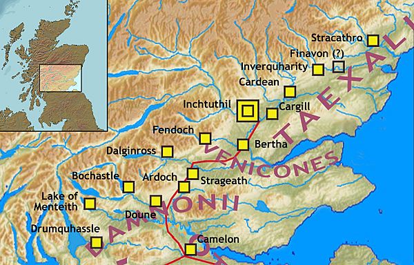
The main forts that were part of the Gask Ridge system included (listed from south to north): Camelon, Drumquhassle, Malling, Doune, Glenbank (a fortlet), Bochastle, Ardoch, Kaims Castle (a fortlet), Strageath, Dalginross, Bertha, Fendoch, Cargill (a fort and fortlet), Inchtuthil (a very large fort for a Roman legion), Cardean, Inverquharity (a fortlet), and Stracathro.
Glenblocker Forts Explained
Some of the forts in the southwest, like Drumquhassle, Malling, Bochastle, Doune, Dalginross, and Fendoch, were often called "glenblocker forts." This name comes from their location. They were built at the entrances of glens (valleys) or straths (wide valleys). This allowed them to watch and control who came in and out of these areas.
All these forts were first built during the Flavian period, named after the Roman emperors of that time. The main glenblocker forts included:
- Drumquhassle (near Drymen): This fort watched over the southern end of Loch Lomond and the road leading back to the Clyde River.
- Malling (on the Lake of Menteith): It overlooked the path to the Duke's Pass and a narrow area between the mountains and the Forth Mosses.
- Bochastle (near Callander): This fort watched the road to Loch Katrine and the Pass of Leny.
- Dalginross (near Comrie): It overlooked the eastern end of Loch Earn.
- Fendoch (north of Crieff): This fort watched over the Sma' Glen.
- Inchtuthil (below Dunkeld): This was a huge fortress for a Roman legion. It was at the mouth of Strath Tay and guarded the main roads leading north towards Inverness.
- Inverquharity (near Kirriemuir): This was a smaller fortlet at the eastern end of Glen Clova.
Some experts debate whether Cardean, Stracathro, and Doune should be called glenblockers. They are a bit further from the main paths they were meant to watch, but they served a similar purpose.
What Was Their Purpose?
People used to think these forts were built to stop attacks from the Scottish Highlands into Roman lands. This might have been part of the plan, especially with the other forts along the Gask Ridge and Strathmore. However, only the large fortress at Inchtuthil, with its 5,000 to 6,000 soldiers, would have been strong enough to handle a major invasion. The smaller forts were probably more for discouraging small groups of raiders.
Some older ideas suggested that the Glenblocker forts and the Gask Ridge were part of a planned Roman withdrawal. But newer research suggests that all three parts – the glenblockers, the Gask Ridge, and the forts along Strathmore – were actually one big border system. This system stretched from Loch Lomond all the way to Montrose. In this idea, the glenblocker forts controlled access to valleys that led back into the Roman frontier, rather than connecting to Iron Age settlements further north. It's thought they were good for watching, but didn't have enough soldiers to stop anything more than cattle theft.
Only the legionary fortress at Inchtuthil was big enough to be a strong defensive point or a starting place for an invasion. It was also well-placed for access into Braemar and the areas beyond. The Gask Road and its watchtowers likely protected the important connection to the harbors on the Firths of Tay and Forth, and the southern part of the Roman province.
The Roman writer Tacitus wrote in his book De vita Iulii Agricolae that Agricola was fighting in this area around 80 A.D. The latest Roman coins found at these sites date from 86 A.D. This suggests that the forts were used for about six years at most. Recent archaeological digs have shown that many Gask Ridge forts were rebuilt, sometimes twice. Interestingly, there's no clear sign that they were destroyed in battles. More digs might help us understand this puzzle.
Some forts like Ardoch, Strageath, and Bertha on the Gask Road, as well as Cargill in Strathmore and the glenblocker fort of Dalginross, also have items from the time of Emperor Antoninus Pius. This shows that these sites were used again when the Antonine Wall was built. Later, during the Severan period, the Roman army passed through this area. There are also Roman camps across Scotland from this time, such as Kair House in Aberdeenshire and the fort at Carpow Roman Fort on the Firth of Tay.
North of the Gask Ridge
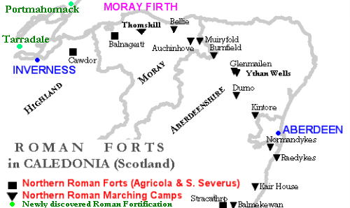
Besides the permanent forts, the Romans also built a series of large marching camps. These were temporary camps used by soldiers on the move. Some of these large camps date to the 3rd century and stretch from the Scottish Lowlands into Aberdeenshire and Moray. In the 1st century, Roman legions set up a chain of forts at Ardoch, Strageath, Inchtuthil, Battledykes (though this one might be from a different time than the Gask sites), Stracathro, and Raedykes. They then traveled over the Elsick Mounth to Normandykes, before heading north to Glenmaillen and Auchinhove. There are also possible Roman fort sites that haven't been fully confirmed yet at Bellie, Balnageith, and Cawdor.
In the 1990s, researchers found new possible Roman defenses north of Inverness and the Moray Firth. The most important of these are Tarradale and Portmahomack. Experts are still studying these sites to confirm if they are Roman. Different ideas have been suggested about when and why they were built.
See also
 In Spanish: Gask Ridge para niños
 | Stephanie Wilson |
 | Charles Bolden |
 | Ronald McNair |
 | Frederick D. Gregory |


