Geography of New Brunswick facts for kids
New Brunswick (which is called Nouveau-Brunswick in French) is one of Canada's three Maritime provinces. These provinces are located near the Atlantic Ocean. While New Brunswick is a Maritime province, it's a bit different from its neighbours, Nova Scotia and Prince Edward Island.
Nova Scotia and Prince Edward Island are mostly surrounded by water. This means the ocean greatly affects their weather, economy, and culture. New Brunswick, however, has a long coastline but is also protected from the open Atlantic Ocean. It has a large inland area that isn't as affected by the ocean. Because of this, New Brunswick is often known more for its many rivers than its seacoast.
Contents
Exploring New Brunswick's Land and Water
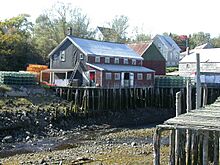
New Brunswick is a province with diverse landscapes, from its coasts to its inland mountains and rivers.
Where is New Brunswick Located?
New Brunswick shares its borders with several places. To the north, it meets Quebec's Gaspé Peninsula and the Bay of Chaleur. To the east, you'll find the Gulf of Saint Lawrence and the Northumberland Strait. In the southeast, a narrow strip of land called the Isthmus of Chignecto connects it to Nova Scotia. To the west, the province borders the US state of Maine.
The total area of New Brunswick, including both land and water, is about 72,908 square kilometres.
New Brunswick's Major Rivers
New Brunswick is famous for its large river systems. The main rivers include the Saint John River, Petitcodiac River, Miramichi River, St. Croix River, and the Restigouche River. The Saint John River is thought to be the second-longest river on the eastern side of North America, between the St. Lawrence River and the Mississippi River.
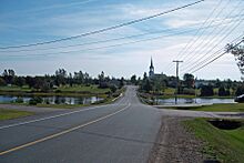
The northern coast, along Miramichi Bay, the Gulf of St. Lawrence, and the Bay of Chaleur, is known as the North Shore. This area is mostly French-speaking, but it also has many English-speaking communities.
What are New Brunswick's Mountains and Hills Like?
New Brunswick is entirely within the Appalachian Mountain range. These are very old, worn-down mountains that have created many river valleys and gentle, rolling hills across the province.
The different land areas in New Brunswick include:
- The Chaleur Uplands: This area stretches from Maine to the north of the province. The Saint John and Restigouche rivers flow through it.
- The Notre Dame Mountains: Located in the northwest corner, these mountains have heights from 150 to 610 meters. They feature many small lakes and steep slopes.
- The New Brunswick Highlands: This area includes the Caledonia, St. Croix, and Miramichi Highlands.
- The Lowlands: Found in the central and eastern parts of the province, this low-lying area is mostly less than 100 meters above sea level. Heights rarely go above 180 meters.
How Water Flows Through New Brunswick
Most of western New Brunswick is drained by the Saint John River system. This river starts in northern Maine and flows into the Bay of Fundy in the city of Saint John. Important rivers that flow into the Saint John River include the Madawaska River, Tobique River, Nashwaak River, and Kennebecasis River.
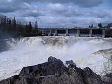
The Bay of Fundy has very high tides. These tides can sometimes make the Saint John River flow backwards, upstream! This is most noticeable at the Reversing Falls in Saint John.
The Petitcodiac River, Shepody River, and Memramcook River flow into Chignecto Bay at the top of the Bay of Fundy. Like the Saint John River, the Bay of Fundy tides create another interesting event here called a tidal bore. This is a wave that travels upstream. A causeway (a raised road or path across water) built on the Petitcodiac River near Moncton has changed this tidal bore and the river's environment.
The Miramichi River system drains a large part of central New Brunswick. This river flows into Miramichi Bay at the city of Miramichi. It has two main branches, the Southwest Miramichi River and Northwest Miramichi River. The Miramichi River system is well-known for its excellent salmon fishing spots and parks.
The Restigouche River system drains a large area of northwestern and north-central New Brunswick. This river flows into the Bay of Chaleur near Dalhousie. Like the Miramichi, it's famous for salmon fishing.
The Nepisiguit River is another important river that flows into the Bay of Chaleur.
New Brunswick's Climate
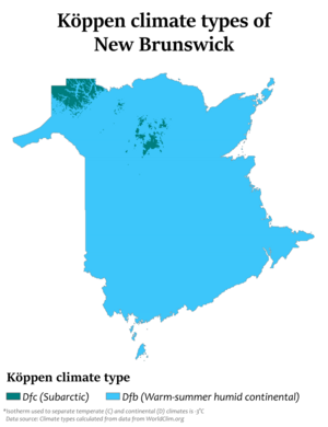
New Brunswick has a humid continental climate throughout the province. This means it has warm summers and cold winters. Along the Gulf of St. Lawrence coastline, winters are slightly milder. The far north of the province has very cold winters, almost like a subarctic climate.
Winters in New Brunswick are generally colder than those in Nova Scotia. This is because New Brunswick is more influenced by the land than the ocean. Summers are often warm, and sometimes even hot.
| Location | July (°C) | July (°F) | January (°C) | January (°F) |
|---|---|---|---|---|
| Fredericton | 25/13 | 78/55 | −4/−15 | 25/5 |
| Moncton | 24/13 | 76/55 | −3/−14 | 25/7 |
| Saint John | 22/11 | 72/53 | −2/−13 | 27/8 |
| Miramichi | 25/13 | 77/54 | −5/−16 | 23/2 |
| Edmundston | 24/11 | 76/52 | −7/−18 | 19/−1 |
| Bathurst | 25/13 | 76/58 | −5/−16 | 22/3 |
| Campbellton | 23/10 | 74/51 | −9/−20 | 16 /−4 |
Where People Live in New Brunswick
About 80% of New Brunswick is covered by forests. The remaining 20% is used for farming and urban areas where cities and towns are located. The largest cities and towns are mostly found in the southern part of the province. Most of the good farming land is in the Upper Saint John River Valley, with some smaller farms in the southeast.
Nearly half of the people in New Brunswick live in rural areas. These are places that are not big cities and have fewer services. However, as cities grow, the areas just outside them start to feel more like urban places, even if they are still considered rural.
Many communities in New Brunswick exist because of their connection to water. Rivers and coastlines allowed people to travel, trade, and access resources easily.
See also
- Communities in New Brunswick
- Counties in New Brunswick
- Schools in New Brunswick
- List of protected areas of New Brunswick
- List of historic places in New Brunswick
 | May Edward Chinn |
 | Rebecca Cole |
 | Alexa Canady |
 | Dorothy Lavinia Brown |


