Geography of Sheffield facts for kids
Sheffield is a really cool city in England, known for its amazing green spaces! It's tucked away in the eastern part of the Pennines mountains and has five rivers flowing through it: the Don, Sheaf, Rivelin, Loxley, and Porter. Because of these rivers and hills, much of Sheffield is built on slopes, giving you awesome views of the city or the countryside.
About one-third of Sheffield is city, one-third is countryside, and one-third is actually inside the beautiful Peak District National Park! The city's lowest point is only 29 meters (about 95 feet) above sea level, but it rises to over 500 meters (about 1,640 feet) in some areas. Most homes are between 100 and 200 meters (328-656 feet) above sea level.
Sheffield is super green! It has more trees per person than any other city in Europe, with four trees for every person. There are over 170 woodlands, 78 public parks, and 10 public gardens. When you add the national park land and water areas, about 61% of the city is green space.
The city also has more types of habitats than any other UK city. You can find urban areas, parkland, woodlands, farms, moors, meadows, and freshwater areas. Many parts of Sheffield, even some city areas, are special protected places called Site of Special Scientific Interests.

Contents
Where is Sheffield Located?

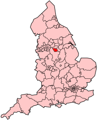
Sheffield is in a special spot in England. Long ago, it was part of a bigger area called the West Riding of Yorkshire. Now, it's part of South Yorkshire county. It's close to the forests of Nottinghamshire and the beautiful Derbyshire Dales.
The city sits right next to Rotherham, with the M1 motorway often marking the border between them. To the west, Sheffield is near the Pennines mountains and the Peak District National Park. To the east, it's close to the South Yorkshire Coalfield. The southern border of Sheffield touches Derbyshire. Over the years, Sheffield has grown, taking in some villages that used to be in Derbyshire.
The larger Sheffield area includes the City of Sheffield, Rotherham, Doncaster, and Barnsley. This whole region, called the Sheffield city region, is home to over 1.8 million people. It also includes smaller towns and villages like Eckington, Worksop, and Chesterfield, which are important for Sheffield's economy.
Sheffield's Rivers and Streams
Sheffield gets its name from the River Sheaf. This river was once called Scheth or Sheath, which means "to divide" or "separate" in Old English. A long time ago, the Sheaf, along with Meers Brook and Limb Brook, helped form the border between two old Anglo-Saxon kingdoms, Mercia and Northumbria.
Limb Brook starts in a village called Ringinglow and flows east to join the Sheaf. Part of this stream was once used to power the Abbeydale Industrial Hamlet millpond, a historic industrial site. The River Sheaf itself begins where Totley Brook and Old Hay Brook meet. Its main smaller rivers are Porter Brook and Meers Brook. The Sheaf flows north to meet the River Don in the city center. This part of the Sheaf and the Don used to form a boundary around Sheffield Castle.

Porter Brook starts inside the Peak District National Park, west of the city. It flows east to meet the Sheaf, right where Sheffield Midland Station is today.
The River Don begins in the Pennines and flows east for about 113 kilometers (70 miles). It passes through towns like Sheffield, Rotherham, and Doncaster. Its major smaller rivers are the Loxley, Rivelin, Sheaf, Rother, and Dearne.
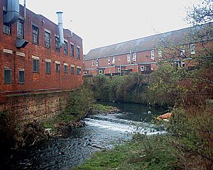
The Rivers Loxley and Rivelin start northwest of Sheffield, on the Hallam moors. The Loxley flows through Damflask Reservoir and joins the Rivelin. Then, they both flow into the River Don. These rivers flow quite fast, especially the Rivelin, because they get a steady supply of water from the nearby moorland. For centuries, the Rivelin's strong flow was used to power water wheels for many industries, like metal-working and flour mills, with some dating back to the 1600s.
The Wyming Brook is another river in Sheffield. It starts at the Redmires Reservoirs and flows steeply downhill into an underground chamber. There, it joins the Rivelin tunnel before flowing into the lower Rivelin Dams.
The River Rother starts in Derbyshire and flows north through Sheffield's eastern suburbs. It joins the River Don in Rotherham. Its main smaller rivers are the River Drone, River Hipper, and River Doe Lea.
Because Sheffield has so many natural waterways, a system of canals was built. These canals were first used for moving goods and now they are popular for fun activities like boating.
Sheffield's History and Nature
How Sheffield Began
The village of Sheffield started a very long time ago, even before the year 1000! It grew around a strong building, which later became Sheffield Castle. This building was located where the Sheaf and Don rivers meet. Many small villages and farms grew up nearby. These places often had early industries that used the power of the five fast-flowing rivers, along with coal and iron mined nearby. You can still see examples of these old industries at museums like Abbeydale Industrial Hamlet, which is very old, and Shepherd Wheel.
These villages slowly grew bigger. By the 1700s, Sheffield was a busy market town and was already famous for making cutlery (like knives and forks).
The Industrial Revolution's Impact
When the Industrial Revolution happened, Sheffield grew super fast. In the 1800s, its size increased more than ten times, reaching 400,000 people! However, this fast growth also caused problems for the environment. Smog (a thick, dirty fog) was common, especially in the city center, which is in a natural bowl shape. The River Don became one of the most polluted rivers in Europe.
But things started to change! In the 1930s, the Sheffield City Council and generous people like J.G.Graves began buying rural land around Sheffield. They wanted to protect it from being built on. This was one of the first times that "greenbelt" land was created in the UK, meaning areas kept natural and undeveloped around a city.
City Areas and Green Spaces
Most of Sheffield's homes are in the south and northwest parts of the city. Many houses were built after World War II because of damage from bombing and projects to clear old, crowded areas. Sometimes, large apartment buildings were built, like Park Hill Flats.
Large parts of the city, especially in the northeast, are industrial areas. These areas saw a big decline in the 1970s and 1980s. To help fix this, the Sheffield Development Corporation was created. Now, many new buildings in these areas are for service industries, like the Meadowhall Centre shopping mall. This area also hosted many events for the World Student Games and is home to the English Institute of Sport.
Even though most of Sheffield's green spaces are outside the main city area, there are still many parks and woodlands within the city itself. The biggest park is Graves Park, and the largest wood is Ecclesall Woods.
Sheffield's Different Areas
Sheffield is made up of many different areas, which vary in size and history. A lot of these areas used to be separate villages or small settlements that became part of Sheffield as the city grew. This means that while it's easy to find the center of most areas, their exact borders can be a bit unclear. For official purposes, the city is divided into 28 electoral wards, with each ward covering several areas.
While most areas are within the main city, some outlying areas like Stocksbridge and Deepcar are still separated by countryside. The rural parts of the city, which make up two-thirds of its total area, are home to fewer than 3,000 people.
Sheffield's Climate
Just like the rest of the United Kingdom, Sheffield has a generally mild climate. Between 1971 and 2000, Sheffield received about 824.7 mm (32.5 inches) of rain each year. December was usually the wettest month, and July was the driest. The average high temperature for the year is about 12°C (53.6°F), and average lows are around 6.5°C (43.7°F). July is also the warmest month, with an average high of 20.8°C (69.4°F). The coldest months are January and February, with average low temperatures of 1.6°C (34.9°F).
Because Sheffield has different altitudes (some parts are higher than others), the weather can change quite a bit across the city. Higher areas like Deepcar and Stocksbridge often get snow first and experience heavier rain.
The high ground of the Peak District to the west usually protects Sheffield from strong winds. This means the city often avoids the worst effects of big storms that hit other parts of the country. However, sometimes if the winds line up just right with the river valleys, Sheffield can be hit hard. This happened during the Great Sheffield Gale in 1962, when four people died and 150,000 houses were damaged.
| Month | Jan | Feb | Mar | Apr | May | Jun | Jul | Aug | Sep | Oct | Nov | Dec | Year |
|---|---|---|---|---|---|---|---|---|---|---|---|---|---|
| Avg high °C (°F) | 5.5 (41.9) | 6 (42.8) | 8.5 (47.3) | 12 (53.6) | 15 (59) | 18 (64.4) | 19.5 (67.1) | 19 (66.2) | 17 (62.6) | 13 (55.4) | 8 (46.4) | 7 (44.6) | 12 (53.6) |
| Avg low temperature °C (°F) | 1.5 (34.7) | 2 (35.6) | 3 (37.4) | 4.5 (40.1) | 6.5 (43.7) | 10.5 (50.9) | 12.5 (54.5) | 12 (54.5) | 10.5 (50.9) | 7.5 (45.5) | 4.5 (40.1) | 2 (35.6) | 6.5 (43.7) |
| Source: J. W. Baggaley, Director of Museums, Sheffield City Council | |||||||||||||
Pollution and Clean Air
In the 1960s, Sheffield had a big pollution problem and was one of the most polluted cities in Europe. But since then, things have gotten much better! The city council started taking action in the 1950s, and the steel industry became much cleaner.
Today, Sheffield's air quality has improved greatly. The city's green spaces and river systems help keep the air clean. The valleys allow cooler air to flow from the hills into the city center and industrial areas. This helps improve air quality and keeps temperatures cooler in the summer.
Sheffield's Green Belt

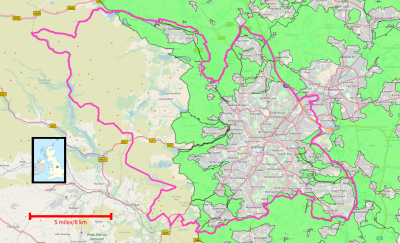
Sheffield is surrounded by a special "green belt" area. This green belt helps stop the city from spreading too much and keeps the towns around Sheffield from growing into one another. It also protects the unique feel of smaller communities and encourages building on old, unused sites instead of new green land. Most importantly, it keeps the beautiful countryside safe.
The green belt goes around the main built-up area of Sheffield, especially preventing growth towards the Peak District National Park. Some larger towns and villages within the Sheffield area, like Oughtibridge and Stocksbridge, are outside the green belt. However, many smaller villages and rural areas are included within it. This green belt was first put in place in 1983.
One of the goals of the green belt is to encourage outdoor activities and fun. It includes many natural areas and facilities like Shire Brook Valley, parks, walking routes, sports grounds, golf courses, and nature reserves. These places offer great opportunities for people to enjoy nature and stay active.
 | Valerie Thomas |
 | Frederick McKinley Jones |
 | George Edward Alcorn Jr. |
 | Thomas Mensah |


