Gogebic County, Michigan facts for kids
Quick facts for kids
Gogebic County
|
||
|---|---|---|

|
||
|
||

Location within the U.S. state of Michigan
|
||
 Michigan's location within the U.S. |
||
| Country | ||
| State | ||
| Founded | 1887 | |
| Named for | Lake Gogebic | |
| Seat | Bessemer | |
| Largest city | Ironwood | |
| Area | ||
| • Total | 1,476 sq mi (3,820 km2) | |
| • Land | 1,102 sq mi (2,850 km2) | |
| • Water | 374 sq mi (970 km2) 25%% | |
| Population
(2020)
|
||
| • Total | 14,380 | |
| • Density | 15/sq mi (6/km2) | |
| Time zone | UTC−6 (Central) | |
| • Summer (DST) | UTC−5 (CDT) | |
| Congressional district | 1st | |
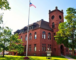
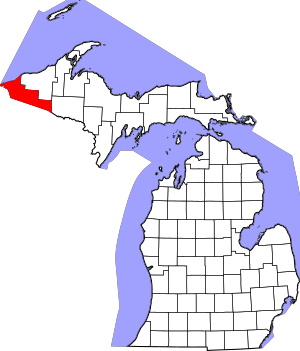
Gogebic County is a county located in the Upper Peninsula of the U.S. state of Michigan. In 2020, about 14,380 people lived there. The main town, or county seat, is Bessemer.
Gogebic County is the westernmost county in Michigan. It's also one of four Michigan counties that are in the Central Time Zone. The county shares a border with Wisconsin to the south and has a beautiful shoreline along Lake Superior to the north.
For a long time, Gogebic County has been home to the Lake Superior Chippewa people. The Lac Vieux Desert Indian Reservation is located within Gogebic County.
Contents
History of Gogebic County
Gogebic County was officially created in 1887. It was formed from a part of Ontonagon County.
The county's name comes from a lake called Lake Gogebic. The original name for the lake was Agogebic. The name comes from the Ojibwe language. People aren't completely sure what the original meaning was. Some think it meant "body of water hanging on high." Others believe it meant "water-mold lake."
Geography of Gogebic County
Gogebic County covers a total area of about 1,476 square miles. About 1,102 square miles of this is land, and 374 square miles (25%) is water.
Water Features
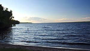
- Lake Superior: This huge lake forms the county's northern border.
- Lake Gogebic: This is the biggest lake in the Upper Peninsula.
- Montreal River: This river forms the county's western border. It also marks the border between Michigan and Wisconsin in this area.
Neighboring Counties
Gogebic County shares its borders with several other counties:
- Ontonagon County: To the north and northeast (this county is in the Eastern Time Zone).
- Iron County: To the east (also in the Central Time Zone).
- Vilas County, Wisconsin: To the south.
- Iron County, Wisconsin: To the southwest.
- Ashland County, Wisconsin: To the northwest.
Protected Natural Areas
- Ottawa National Forest: A large part of this national forest is located within Gogebic County.
- Lake Gogebic State Park: This state park offers outdoor activities and is located near Lake Gogebic.
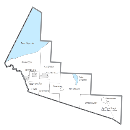
Communities in Gogebic County
Gogebic County has several different types of communities where people live.
Cities
- Bessemer: This is the county seat, meaning it's where the county government is located.
- Ironwood
- Wakefield
Townships
- Ironwood Charter Township
- Bessemer Township
- Erwin Township
- Marenisco Township
- Wakefield Township
- Watersmeet Township
Other Communities
These are smaller, unincorporated places:
Indian Reservations
Population of Gogebic County
| Historical population | |||
|---|---|---|---|
| Census | Pop. | %± | |
| 1890 | 13,166 | — | |
| 1900 | 16,738 | 27.1% | |
| 1910 | 23,333 | 39.4% | |
| 1920 | 33,225 | 42.4% | |
| 1930 | 31,577 | −5.0% | |
| 1940 | 31,797 | 0.7% | |
| 1950 | 27,053 | −14.9% | |
| 1960 | 24,370 | −9.9% | |
| 1970 | 20,676 | −15.2% | |
| 1980 | 19,686 | −4.8% | |
| 1990 | 18,052 | −8.3% | |
| 2000 | 17,370 | −3.8% | |
| 2010 | 16,427 | −5.4% | |
| 2020 | 14,380 | −12.5% | |
| 2023 (est.) | 14,224 | −13.4% | |
| U.S. Decennial Census 1790-1960 1900-1990 1990-2000 2010-2018 |
|||
In 2010, Gogebic County had a population of 16,427 people. By 2020, the population had decreased to 14,380.
Most people living in Gogebic County are of European descent. Many families have roots from countries like Germany, Italy, England, and Poland.
Sports in Gogebic County
Gogebic County is special because it's the only place in the Upper Peninsula that has ever had a professional sports team. The team was called the Gogebic Panthers. They played football in the Northwest Football League in 1935 and 1936.
In 1935, the Panthers had a great season, winning 6 games and only losing 1. Their only loss was to the La Crosse Old Style Lagers, who ended up winning the league championship. In 1936, they even beat the Madison Cardinals 6-0.
Transportation in Gogebic County
Getting around Gogebic County is made easier by several major roads and an airport.
Major Highways
 US 2
US 2
 Bus. US 2: This road serves the city of Ironwood.
 US 45
US 45 M-28
M-28 M-64
M-64
Public Transport
- Indian Trails: This service provides bus transportation.
Airport
- KIWD - Gogebic-Iron County Airport: This airport is about 7 miles northeast of Ironwood. You can find commercial flights here.
See also
 In Spanish: Condado de Gogebic para niños
 | Emma Amos |
 | Edward Mitchell Bannister |
 | Larry D. Alexander |
 | Ernie Barnes |


