
Goliad Formation facts for kids
Quick facts for kids Goliad FormationStratigraphic range: Clarendonian-Blancan ~13.6–5.2Ma |
|
|---|---|
| Type | Formation |
| Sub-units | Lapara, Lagarto Creek & Labahia Members |
| Underlies | Pleistocene terrace deposits |
| Overlies | Fleming Formation |
| Thickness | 60–425 m (197–1,394 ft) |
| Lithology | |
| Primary | Sandstone, claystone |
| Other | Marl, caliche, limestone, conglomerate |
| Location | |
| Coordinates | 28°36′N 97°42′W / 28.6°N 97.7°W |
| Approximate paleocoordinates | 29°00′N 95°18′W / 29.0°N 95.3°W |
| Region | Bee, Goliad, Hidalgo & Live Oak counties, Texas |
| Country | |
| Extent | Texas coastal plain |
| Type section | |
| Named for | Goliad County |
| Named by | Plummer |
| Year defined | 1932 |
The Goliad Formation (Tg) is a special type of rock layer found in Texas. It's like a giant history book made of rock. This formation holds fossils that tell us about life from long ago. These fossils date back to the Serravallian to earliest Pliocene stages. This time period is part of the Neogene period, which was millions of years ago.
Scientists use a special way to classify these ages, called the NALMA classification. In this system, the Goliad Formation includes fossils from the Clarendonian, Hemphillian, and earliest Blancan ages. Among the many amazing finds, there's a type of ancient elephant relative called a gomphothere named Blancotherium. Many other fossil mammals, reptiles, birds, and fish have also been found here.
Besides fossils, the Goliad Formation is important for other reasons. It contains uranium deposits, which are used for energy. It also forms a huge underground water source called the Evangeline aquifer. This aquifer provides water to the city of Houston.
Contents
What is the Goliad Formation?
The Goliad Formation was first described by a scientist named Plummer in 1933. He explained that it is made up of three main parts, which he called "members." These are the Lapara Sand, the Lagarto Creek Beds, and the Labahia Beds. When you see these layers on the surface, they can be from 35 to 200 feet (11 to 61 m) thick.
Rocks and Layers
The Goliad Formation is made of different types of rocks. These include claystone, sand, sandstone, marl, and a hardened soil called caliche. You can also find limestone and conglomerates (rocks made of many smaller pieces stuck together). In some places, this formation can be as thick as 180 metres (590 ft)!
The Goliad Formation sits on top of another rock layer called the Fleming Formation. It formed during the Clarendonian to the earliest Blancan ages. In the southwestern part of Texas, it also sits on top of the Catahoula and Gueydan Formations.
Scientists recognize the Goliad Formation across the Texas coastal plain. It's known for its layers of sand and clay that were mostly deposited by ancient rivers. These layers sit above the Fleming Formation and below younger deposits from the Pleistocene Ice Age. Geologists now believe the Goliad Formation is a thick wedge of rock layers. These layers got thicker as they spread out towards the ancient ocean during the Middle and Late Miocene epochs. On the surface, the formation is about 60 to 120 metres (200 to 390 ft) thick. But deeper underground, it can be much thicker, reaching up to 365 to 425 metres (1,198 to 1,394 ft)!
Water and Resources
The Goliad Formation is part of a larger system called the Gulf Coast aquifer. This is a massive underground water supply that provides water for farms and cities. The Evangeline aquifer, which supplies water to Houston, is specifically found within the Goliad Formation.
This rock formation also holds important natural resources. It contains uranium deposits in an area known as the South Texas Uranium Province. Uranium is a metal used to produce nuclear energy. The formation is also mined for caliche in Hidalgo County, Texas. Caliche is a type of hardened soil that can be used in construction.
Ancient Life: Fossils of the Goliad Formation
The Goliad Formation is famous for its amazing collection of fossils. These fossils give us clues about the animals that lived in Texas millions of years ago. The first reports of mammal fossils from this area were made by Dumble in 1894. He found them in what was then called the Lapara division, which is now part of the Goliad Formation.
Scientists have found many different types of ancient animals in this formation. Here are some examples of the incredible creatures discovered:
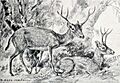
- Mammals: Many ancient mammals have been found. These include relatives of modern-day dogs like Aelurodon taxoides and Leptocyon vafer. There are also ancient horses such as Calippus martini, Dinohippus subvenus, and Hipparion tehonense. Early camels like Procamelus grandis and Megatylopus primaevus also roamed this area. One unique mammal found is Ceratogaulus rhinocerus, a horned gopher! Another interesting find is Synthetoceras tricornatus, a deer-like animal with three horns. Ancient rhinoceroses like Teleoceras major have also been identified. The Blancotherium buckneri is a type of gomphothere, an ancient elephant relative.
- Birds: Fossils of ancient birds have been discovered, including types of waterfowl like cf. Anserinae indet..
- Reptiles: Many reptiles lived here, including ancient alligators like Alligator cf. mississippiensis. Different types of turtles have also been found, such as Apalone sp., Hesperotestudo sp., and Trionyx sp.
- Fish: The Goliad Formation also preserves fossils of ancient fish. These include types of catfish like Pylodictis olivaris and Ictalurus cf. lambda, as well as gar-like fish such as Lepisosteus sp.
These fossils help scientists understand what the environment was like in Texas millions of years ago. They show us a diverse ecosystem with many different animals living together.
Images for kids
-
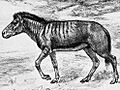
An artist's idea of what Aelurodon taxoides might have looked like.
-
A reconstruction of Ceratogaulus rhinocerus, the horned gopher.
-
An artistic depiction of Cormohipparion occidentale, an ancient horse.
-
A life restoration of Cranioceras unicornis, a deer-like mammal.
-
A skeleton of Dinohippus, an ancient horse.
-
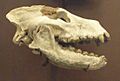
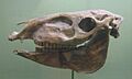
A fossil skull of Hipparion, another ancient horse.
-
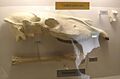
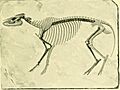
The skeleton of Hypohippus, an ancient horse.
-

A head restoration of Leptocyon, an ancient dog.
-
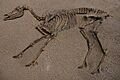
A skeleton of Titanotylopus, an ancient camel relative.
-
An illustration of Neohipparion affine.
-
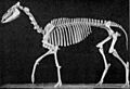
A skeleton of Pliohippus pernix, an ancient horse.
-
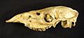
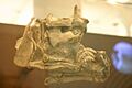
A fossil skull of Procamelus, an ancient camel.
-
An illustration of Protohippus supremus, an ancient horse.
-
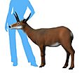
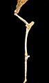
A skeleton of Merycodus osborni, a pronghorn relative.
-

A life restoration of Synthetoceras tricoronatus, a three-horned mammal.
-
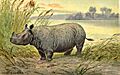
A skeleton of Teleoceras, an ancient rhinoceros.
-

A modern American alligator, similar to ancient alligators found.
-
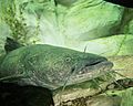
A modern flathead catfish, similar to ancient fish found.


.jpg)


_(14591795580).jpg)


