Granby, Connecticut facts for kids
Quick facts for kids
Granby, Connecticut
|
||
|---|---|---|
| Town of Granby | ||
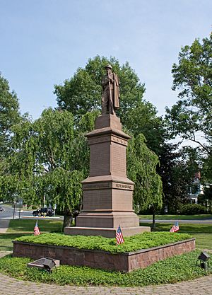
Civil War Soldiers' Monument in the town center
|
||
|
||
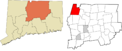
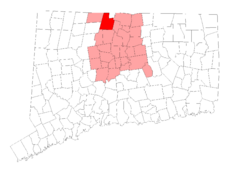 Hartford County and Connecticut Hartford County and Connecticut |
||
| Country | ||
| U.S. state | ||
| County | Hartford | |
| Region | Capitol Region | |
| Settled | 1723 | |
| Incorporated | 1786 | |
| Villages | Granby (Salmon Brook) Five Points Goodrichville Hungary Mechanicsville North Granby Pegville West Granby |
|
| Government | ||
| • Type | Board of selectmen-town manager | |
| Area | ||
| • Total | 40.8 sq mi (105.7 km2) | |
| • Land | 40.7 sq mi (105.4 km2) | |
| • Water | 0.2 sq mi (0.4 km2) | |
| Elevation | 550 ft (167 m) | |
| Population
(2020)
|
||
| • Total | 10,903 | |
| • Density | 267.16/sq mi (103.15/km2) | |
| Time zone | UTC-5 (Eastern) | |
| • Summer (DST) | UTC-4 (Eastern) | |
| ZIP Codes |
06035, 06060, 06090
|
|
| Area code(s) | 860/959 | |
| FIPS code | 09-32640 | |
| GNIS feature ID | 0213434 | |
| Major highways | ||
Granby is a town in northern Hartford County, Connecticut, United States. It's part of the Capitol Planning Region. In 2020, about 10,903 people lived here. The main part of town is called Salmon Brook. Other areas include North Granby and West Granby.
Granby is a rural town with lots of woods and rolling hills. It's located in the foothills of the Litchfield Hills, which are part of the Berkshires mountain range. From the 1890s to the 1920s, many people from Sweden came to live in Granby.
Contents
History of Granby
Granby was first settled around 1723 by people from a nearby town called Simsbury. It was part of Simsbury until 1786, when it became its own independent town. The name "Granby" comes from Granby, Massachusetts, which was named after a British general, John Manners, Marquess of Granby.
Early Border Changes
A small piece of land called "the Notch" used to be part of Southwick, Massachusetts. In 1774, this area decided to join Connecticut. It became part of Granby when Granby became a separate town. However, after a border disagreement between Connecticut and Massachusetts in 1803–1804, "the Notch" was returned to Southwick.
The Story of Daniel Hayes
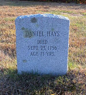
In 1707, a young man named Daniel Hayes, who was about 22 years old, was captured by a Native American tribe and taken to Canada. A rescue team tried to find him but couldn't catch up. Daniel was tied up every night during the 30-day journey.
When they reached Canada, he was forced to run a gauntlet, which was a tough challenge. He managed to hide in a wigwam, where a woman adopted him as her son. She had lost her own husband and son in a war. Daniel stayed with her for several years. Later, he was sold to a Frenchman who discovered Daniel was a skilled weaver. Daniel worked hard and earned enough money to buy his freedom after two years. He then returned to Simsbury, started a farm, and got married. He became an important person in his community and church in Salmon Brook, which is now Granby.
Connecticut's First Coins
In 1737, Dr. Samuel Higley made the first unofficial coins in the American colonies right here in what is now Granby! He used copper from his own mine. These coins, including the Trader's Currency Token of the Colony of Connecticut, were made of pure copper, which is very soft. Because of this, very few of them still exist today. The first coins said they were worth "three pence." Later ones had a fun phrase: "Value me as you please."
Becoming East Granby
In 1858, the eastern part of Granby separated to form its own town, called East Granby. This made East Granby one of the newer towns in Connecticut.
Granby's Recognition
In 2009, Connecticut Magazine ranked Granby as the third best small town in Connecticut for towns with 10,000 to 15,000 people. It was also ranked the number one small town in Hartford County!
The Dewey-Granby Oak
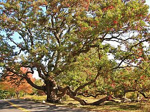
The town's official seal shows a huge white oak tree called the Dewey-Granby Oak. Experts believe this tree is between 450 and 500 years old, making it one of the oldest trees in all of New England!
Geography and Nature
Granby covers about 105.7 square kilometers (about 40.8 square miles). Most of this area is land, with a small amount of water. The town center, Salmon Brook, is about 7.8 square kilometers (3 square miles).
The highest point in Granby is about 351 meters (1,153 feet) high in West Granby. The town has many dense woodlands. You might even spot animals like black bears, eastern moose, and white-tailed deer living there.
Climate in Granby
Summers in Granby are usually warm and often humid, with occasional thunderstorms. Winters can bring heavy snow and cold temperatures. It's not unusual to have snow and cold weather in early spring and late fall because Granby is located in the Berkshires foothills.
People of Granby (Demographics)
| Historical population | |||
|---|---|---|---|
| Census | Pop. | %± | |
| 1820 | 3,012 | — | |
| 1850 | 2,498 | — | |
| 1860 | 1,720 | −31.1% | |
| 1870 | 1,517 | −11.8% | |
| 1880 | 1,340 | −11.7% | |
| 1890 | 1,251 | −6.6% | |
| 1900 | 1,299 | 3.8% | |
| 1910 | 1,383 | 6.5% | |
| 1920 | 1,342 | −3.0% | |
| 1930 | 1,388 | 3.4% | |
| 1940 | 1,544 | 11.2% | |
| 1950 | 2,693 | 74.4% | |
| 1960 | 4,968 | 84.5% | |
| 1970 | 6,150 | 23.8% | |
| 1980 | 7,956 | 29.4% | |
| 1990 | 9,369 | 17.8% | |
| 2000 | 10,347 | 10.4% | |
| 2010 | 11,282 | 9.0% | |
| 2020 | 10,903 | −3.4% | |
| U.S. Decennial Census | |||
In 2000, there were 10,347 people living in Granby. There were 3,781 households, and 2,994 of these were families. The population density was about 254 people per square mile.
Most people in Granby (about 97.5%) were White. About 0.6% were African American, and 0.7% were Asian. About 1.3% of the population identified as Hispanic or Latino.
Household Information
About 39.5% of households had children under 18 living with them. Most households (71.1%) were married couples living together. About 16.5% of households were individuals living alone. The average household had 2.71 people.
Age and Income
The population was spread out by age. About 27.3% were under 18, and 11.0% were 65 or older. The average age in Granby was 40 years old.
In 2000, the average income for a household in Granby was $81,151. For families, the average income was $90,057.
Education in Granby
Granby has a public school system with four schools:
- Kelly Lane Primary School (for students in Kindergarten to 2nd grade)
- Wells Road Intermediate School (for students in 3rd to 5th grade)
- Granby Memorial Middle School (for students in 6th to 8th grade)
- Granby Memorial High School (for students in 9th to 12th grade)
Economy and Jobs
Granby has several important employers that provide jobs for many people.
Top Employers in Granby
Here are some of the biggest employers in Granby, based on a 2023 report:
| # | Employer | # of Employees |
|---|---|---|
| 1 | Town of Granby | 300-375 |
| 2 | Meadowbrook of Granby | 100-249 |
| 3 | Imperial Nursery/Monrovia | 100-249 |
| 4 | Stop & Shop | 100-249 |
| 5 | Geissler's Supermarket | 100-249 |
| 6 | Keller Williams Classic Reality | 100-249 |
| 7 | Salmon Brook Vet Hospital | 50-99 |
| 8 | State Line Energy | 50-99 |
| 9 | High Meadow Day Camp | 50-99 |
| 10 | Farmington Valley YMCA | 50-99 |
Historic Places to Visit
Granby has several places listed on the National Register of Historic Places. These are important sites that help tell the story of the town's past.
- Allen's Cider Mill
- Frederick H. Cossitt Library
- Granby Center Historic District
- Samuel Hayes II House
- Judah Holcomb House
- Nathaniel Holcomb III House
- Rowe and Weed Houses
- West Granby Historic District
Famous People from Granby
Many interesting people have connections to Granby:
- Adam Burt (born 1969), a former professional hockey player in the NHL
- Joe Bouchard (born 1948), a musician and member of the band Blue Öyster Cult
- Jesse Camp (born 1979), a former MTV video jockey
- Chauncey Forward (1793–1839), a congressman from Pennsylvania
- Bryan Nash Gill (1961–2013), an artist
- George S. Godard (1865–1936), a librarian
- Philip C. Hayes (1833–1916), a congressman from Illinois
- Byron Kilbourn (1801–1870), a surveyor and politician
- Rebecca Lobo (born 1973), a former professional basketball player in the Women's National Basketball Association (WNBA)
- Garrett Lucash (born 1978), a figure skater
- Theodore Mills Maltbie (1842–1915), a lawyer and politician
- William M. Maltbie (1880–1961), a Chief Justice of the Connecticut Supreme Court
- Aaron Draper Shattuck (1832–1928), a painter known for his landscapes
See also
 In Spanish: Granby (Connecticut) para niños


