
Hamilton Hills, Baltimore facts for kids
Quick facts for kids
Hamilton Hills
|
|
|---|---|
|
Neighborhood of Baltimore
|
|

Sign for Baltimore's Hamilton Hills neighborhood that says "Hamilton Hills" (2021)
|
|

Hamilton Hills
Location in Baltimore

Hamilton Hills
Location in Maryland

Hamilton Hills
Location in the United States
|
|
| Country | |
| State | |
| City | |
| City Council | District 3 |
| Named for | Captain Hamilton Caughey |
| Area | |
| • Total | 1.14 sq mi (3.0 km2) |
| Elevation | 250–365 ft (76–111 m) |
| Population | |
| • Estimate
(2020)
|
9,649 |
| • Density | 8,464/sq mi (3,268/km2) |
| Race and Ethnicity | |
| • Black | 72.2% (2020) |
| • White | 19.8% |
| • Some other race | 3.4% |
| • Two or more races | 4.2% |
| • Hispanic or Latino (any race) | 3.5% |
| Economics | |
| • Median income | $57,100 (2019) |
| Time zone | UTC−5 (Eastern) |
| • Summer (DST) | UTC−4 (EDT) |
| ZIP Codes |
21214, 21234, 21239
|
| Area Codes | 410, 443, 667 |
Hamilton Hills is a lively neighborhood in the northeastern part of Baltimore, Maryland. It's a mix of homes and businesses, and it's part of a bigger historic area called Hamilton. The main road here is Harford Road, which has been important to the area for a long time.
This neighborhood was once farmland and a small village. It became part of Baltimore City in 1918. Over the years, more houses were built, and shops opened along Harford Road. Hamilton Hills is known as a good place for families. People in the area are working hard to keep Harford Road's businesses strong and protect the neighborhood's good name. In 2003, the neighborhood officially got its current name, Hamilton Hills.
Hamilton Hills has kept its population steady, unlike some other parts of Baltimore. In 2020, it was the 5th largest neighborhood in the city by population. People living here often have higher incomes, live longer, and have lower crime rates than the rest of Baltimore. They also vote more often. Most adults in Hamilton Hills finish high school, but fewer complete college compared to the city average.
Hamilton Hills is part of the 3rd District of the Baltimore City Council. Students attend local public schools, and the neighborhood has post offices and a public library. It also has parks and fun cultural spots.
History of Hamilton Hills
Early Days: Native Americans and Settlers
Long ago, the Susquehannock people lived in the area that is now Baltimore. They used the hilly land for hunting. In the 1600s, English settlers from the Maryland Colony moved north into this area. They gradually took over the land from the Susquehannocks.
In the 1700s, not many people lived in Northeast Baltimore. An English company, Principio Iron Company, bought a lot of land here to make pig iron. They shipped much of it to England. They probably used the natural resources from the area that became Hamilton.
During the American Revolutionary War in 1780, Maryland took back all British property, including Principio's land. Rich merchants from Baltimore Town built large estates, and farmers grew food for the region. Harford Road was built around 1791. It helped merchants and farmers trade with Baltimore Town. Most of the Harford Road area stayed in Baltimore County until the 1900s.
The 1800s: A Village Grows

In the early 1800s, Harford Road was bumpy and hard to travel. In 1819, it became a toll road, meaning people paid to use it, and in return, it was kept in good shape. Over time, more streets were built, and small villages grew around busy intersections. One of these became Hamilton's nearby neighborhood, Lauraville.
Another village grew on Harford Road, between Old Harford Road and Tames Lane. This village later became Hamilton. In its earliest days, it was called North Lauraville. By the late 1800s, North Lauraville was known as a place for travelers to rest and get supplies for their horses and carriages. Tames Lane, now Hamilton Avenue, was named after the Tames brothers, who opened the first general store there.
Later in the 1800s, a retired sea captain named Hamilton Caughey gave land to extend Tames Lane. In his honor, the lane was renamed Hamilton Lane, and then Hamilton Avenue. When a new post office opened, it was named "Hamilton" to show it was a separate community.
In 1898, electric streetcar service came to Hamilton from downtown Baltimore. This made it easier for people to travel to work in the city. Because of this, many new homes were built in the area over the next few decades.
The 1900s: From Village to Modern Neighborhood

After 1900, developers bought Hamilton's old farms and estates to build new houses. In 1905, Evergreen Lawn was the first new housing area. Between 1900 and 1919, ten new housing areas were built for middle-class families. Many streets today are named after early residents or historic places.
As more people moved to Hamilton, more businesses and community groups started. Shops like drug stores and dressmaking opened on Harford Road and Hamilton Avenue. The Hamilton Hall building was built as a popular meeting spot. Many churches started their first meetings in Hamilton Hall. Two neighborhood groups, the Hamilton Improvement Association and the Hamilton Women's Club, worked to make the area better.
In 1918, Baltimore City added Hamilton and other parts of Northeast Baltimore from Baltimore County. The city gave tax breaks to residents and developers in these new areas. It also brought water, sewer, and other services to Hamilton.
After this, Baltimore City started building new roads to connect its eastern and western parts. Northern Parkway began in 1926, and Echodale Avenue was built in 1935. By the mid-1920s, Harford Road became a public road. These roads made it easier for Hamilton residents to get around the city.
Mid to Late 1900s Changes

Throughout the 1900s, Hamilton was seen as a nice, family-friendly suburb with a busy main street on Harford Road. After a lot of new homes were built after World War II, most of the land for houses was used up. The last big housing projects were apartment buildings built in the late 1960s and 1970s.
In the 1940s and 1950s, Baltimore changed its electric streetcar system to buses. Companies like General Motors and Standard Oil influenced this change. Hamilton's streetcar service on Harford Road stopped on June 19, 1956. This change affected the businesses on Harford Road. Over time, many shops moved to strip malls and later to shopping malls.
Hamilton's look and feel changed in the second half of the 1900s. It became more of a place people passed through than a place they visited. Many White residents moved away from Baltimore and Hamilton as new suburban areas grew in nearby counties. After schools in Baltimore became integrated in the 1950s and 1960s, more Black students attended public schools in the city and in Hamilton. Hamilton became a more diverse area after Baltimore's population reached its highest point in the 1950s.
The 2000s: Revitalization and Recognition

To help improve the Hamilton-Lauraville area, local groups started working to make the Harford Road area better in the 1990s and 2000s. Hamilton-Lauraville Main Street, a nonprofit organization, was created to help local businesses and improve life for residents. This group has held cultural events and given money to businesses for improvements.
In 2000, the neighborhood group for what became Hamilton Hills named it Harford Echodale Perring Parkway (HEPP). In 2003, they changed the name to Hamilton Hills, which it is still called today.
Hamilton, and Hamilton Hills, have been recognized as great places to live. In 2014, The Baltimore Sun newspaper said Hamilton was one of the top up-and-coming places in the Baltimore area. In 2019, the real estate website Redfin ranked Hamilton as one of the hottest affordable neighborhoods in the United States.
Geography and Landscape
Hamilton Hills' boundaries have changed over time. Today, its borders are Old Harford Road and Harford Road to the east, Echodale Avenue to the south, Perring Parkway to the west, and the Baltimore County line to the north. Some groups still include Hamilton Hills in data for a larger area called Harford-Echodale-Perring-Parkway (HEPP).

The land in Hamilton Hills has gentle rolling hills, typical of the Piedmont region in the Eastern United States. The elevation in Hamilton Hills ranges from 250 feet (76 meters) above sea level near Herring Run to 365 feet (111 meters) near Old Harford Road and Moore Avenue. The soil is mostly clay-like and fairly fertile.
Hamilton Hills covers an area of 1.14 square miles (3.0 km²). In 2020, it was the 8th largest neighborhood in Baltimore by total area. Most of Hamilton Hills is land, but a small part of Herring Run flows through its southwest corner. In 2017, about 29.6% of the land in the larger HEPP area was covered by trees.
Neighboring communities include Glenham-Belhar, Lauraville, Loch Raven, North Harford Road, Waltherson, and Westfield. Parkville is just north of Hamilton Hills, across the Baltimore County line. You can also see parts of the Morgan State University campus from some of Hamilton Hills' higher spots.
Population and People
According to the United States Census, the number of people living in Hamilton Hills has stayed about the same in the 2000s. In 2000, there were about 9,679 residents. By 2020, there were an estimated 9,649 residents. This makes Hamilton Hills the 5th largest neighborhood in Baltimore by population.
The population of Hamilton Hills has become more diverse. In 2000, about 58.5% of residents were Black or African American, and 38.0% were White. By 2020, about 72.2% of residents were Black or African American, and 19.8% were White. About 3.5% of residents were Hispanic or Latino in 2020.
In 2019, about 55.4% of Hamilton Hills residents were female, and 44.6% were male. The average age was about 35.2 years old, which is similar to the average age for all of Baltimore. About 6.6% of residents were under 5 years old.
The estimated median household income in 2019 was $57,100. This was higher than the average income for all of Baltimore, which was $50,400. Fewer households in Hamilton Hills received cash assistance or food benefits compared to the rest of the city.
Hamilton Hills had fewer empty homes and more homeowners in 2020 than Baltimore as a whole. About 6.3% of homes were empty, which is lower than the city's 16.6% vacancy rate. About 56.9% of residents owned their homes, while 43.1% rented. In Baltimore overall, about 51.0% of homes were owner-occupied.
Culture and Community Life

Art is a big part of the Hamilton-Lauraville area, including Hamilton Hills. You can see several murals thanks to the Baltimore Mural Program. Many restaurants in Hamilton Hills also have live music. There are also places like Chapterhouse Tattoo, the Hamilton Arts Collective, and the Strand Theater that support arts and entertainment.
The Hamilton Lauraville Main Street group has hosted many cultural events. For example, they organize First Friday events along Harford Road. Since 2010, they have also sponsored the Downhill Derby, an annual soap box derby race in Hamilton Hills.
The restaurants on Harford Road are well-known for their good food. In 2019, a food reporter called the Hamilton-Lauraville area "Baltimore's low-key foodie neighborhood." Clementine, a restaurant that used to be there, was even featured on the Food Network show Diners, Drive-Ins and Dives.
Most homes in Hamilton Hills are single-family houses or semi-detached houses with front porches and big yards. Because many houses have plenty of yard space, hundreds of urban gardeners and farmers live in the area. In 2021, a Facebook group for gardeners in Hamilton-Lauraville had over 1,000 members!
Parks and Fun Places

The Baltimore City Department of Recreation and Parks manages most parks in Baltimore. They manage Hamilton Hills' North Harford Park, which has sports fields and other fun facilities at 6800 Hamlet Avenue. Hamilton Hills also has two urban green spaces: HEPP Park, a four-acre (0.02 km²) woodland area at 2399 Pinewood Avenue, and a part of Herring Run that flows into Herring Run Park.
Famous People from Hamilton
Some notable people who have lived in the Hamilton area include:
- Munro Leaf (1905–1976), a children's book author and illustrator. He created the famous character Ferdinand the Bull.
- E. Ruth Hedeman (1910–2006), a solar astronomer who studied solar cycles.
- Lou Grasmick (1924–2016), a businessman, giver, and professional baseball pitcher for Major League Baseball (MLB).
- Jack Scarbath (1930–2020), a professional American football quarterback in the National Football League (NFL).
- Matthew Porterfield (1977–), an independent filmmaker. He wrote and directed the 2006 movie Hamilton, which takes place in the Hamilton area.
Education in Hamilton Hills
In 2019, Hamilton Hills had more high school graduates than Baltimore as a whole. About 90.5% of adults 25 or older had at least a high school diploma. However, fewer residents completed college compared to the rest of the city.
Schools in the Neighborhood
Baltimore offers students choices for middle and high school. Elementary students usually go to schools based on their area, but they can apply to charter schools. In Hamilton Hills, students in pre-kindergarten through 8th grade are usually assigned to three public schools run by Baltimore City Public Schools.
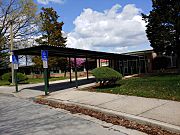
- Hamilton Elementary/Middle School is at 6101 Old Harford Road in Hamilton Hills. It serves students from pre-kindergarten to 8th grade. In 2019, 865 students attended this school.
- Woodhome Elementary/Middle School is at 7300 Moyer Avenue in the North Harford Road neighborhood. It serves students from pre-kindergarten to 8th grade. In 2019, 387 students attended this school.
- Yorkwood Elementary School is at 5931 Yorkwood Road in Loch Raven. It serves students from pre-kindergarten to 5th grade. In 2019, 418 students attended this school.
Two public high schools are also located in Hamilton Hills:
- Reginald F. Lewis High School is at 6401 Pioneer Drive. It serves students in grades 9 through 12. Students are chosen by a lottery if too many apply. In 2019, 541 students attended this school.
- Success Academy is an alternative high school at 2201 Pinewood Avenue. It serves students in grades 9 through 12 with special needs.
- Public schools zoned for Hamilton Hills students or located in Hamilton Hills
-

Front entrance of Hamilton Elementary-Middle School in Hamilton Hills (2021)
-
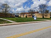
Front entrance of Woodhome Elementary-Middle School in North Harford Road (2021)
-
Front entrance of Yorkwood Elementary School in Loch Raven (2021)
-
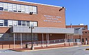
Front entrance of Reginald F. Lewis High School in Hamilton Hills (2007)


Local Library
The Enoch Pratt Free Library system has the Hamilton Branch Library at 5910 Harford Road. The original library opened in 1920. After many new homes were built, the larger Hamilton Branch building opened in 1959.
In 2018, about 19.3% of residents in the HEPP area had library cards. This was lower than the average of 27.8% across all Baltimore neighborhoods.
Postal Services
The United States Postal Service (USPS) uses three ZIP Codes in Hamilton Hills: 21214, 21234, and 21239. They have three post offices that serve the neighborhood:
- The Hamilton Post Office is at 4901 Harford Road. It delivers mail for the 21214 and 21239 ZIP Codes.
- The Northwood Post Office is at 1800 E Northern Parkway. It delivers mail for parts of the 21214 and 21234 ZIP Codes.
- The Parkville Post Office is at 8201 Harford Road in Parkville. It delivers mail for parts of the 21234 ZIP Code.
Transportation and Utilities
Getting Around Hamilton Hills
Road Improvements
,_Baltimore,_MD_21214.jpg)
In 2019, the Baltimore City Department of Transportation made changes to Harford Road. They added separate bike lanes, special bus stops that float out from the curb, and more parking spots. These changes were part of a project to improve the Hamilton Business District. They also reduced the number of car lanes from four to three. This project helped make Harford Road safer for bikes and pedestrians.
Buses and Trains
The Maryland Transit Authority (MTA) has several public bus routes that go through Hamilton Hills. These include LocalLink Routes 30, 33, 36, and 54, and ExpressLink Route 154. These buses travel along Northern Parkway and Harford Road. The MTA also has a service called MobilityLink for riders who cannot use regular buses or trains.
There hasn't been train service in Hamilton Hills since 1956, when the electric streetcar service on Harford Road was replaced by buses. As of 2020, the MTA does not plan to add train service to Hamilton in the future.
Main Roads and Highways
Harford Road, also known as Maryland Route 147, is a very important road in the neighborhood's history. It is a state highway that runs for 18.8 miles (30.3 km) from Baltimore to Bel Air. The part of Harford Road that goes through Hamilton Hills is 0.5 miles long (0.8 km) and forms part of the neighborhood's eastern border. Harford Road also connects drivers to Interstate 695.
Perring Parkway, or Maryland Route 41, is another state highway in Hamilton Hills. It runs for 6.8 miles (10.9 km). The part of Perring Parkway in Hamilton Hills forms the neighborhood's western border and is 1.3 miles long (2.1 km). Perring Parkway also connects drivers to Interstate 695.
Other important roads in Hamilton Hills include Old Harford Road, which connects to the elementary/middle school and library. Northern Parkway runs east to west across the city. Echodale Avenue forms the neighborhood's southern border. Hamilton Avenue, named after Captain Hamilton Caughey, connects Harford Road to Belair Road.
Community Services

Electric power and natural gas are provided to Hamilton Hills by Baltimore Gas and Electric (BGE). BGE is a company that serves the Baltimore area.
Water and sewer services are provided by the Baltimore City Department of Public Works (DPW). Hamilton Hills gets its water from several sources, which are cleaned at the Ashburton and Lake Montebello filtration plants.
The DPW also collects garbage, recycling, and yard waste from homes in Hamilton Hills. They also help with neighborhood cleaning requests through Baltimore's 3-1-1 service system.
Images for kids
-
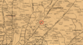
Map showing Harford Road and Tames Lane (now Hamilton Avenue) in 1863
-
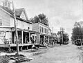
View of Harford Road in 1910, looking south from what is now 5535 Harford Road
-
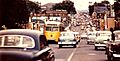
Southbound view of Harford Road at White Avenue with streetcars and cars in 1956
-
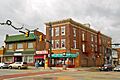
The southwest corner of Harford Road and Hamilton Avenue in 2013
-
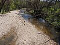
Herring Run, seen from Woodbourne Avenue in 2021
-

The "Live Love Hamilton" mural on the Silver Queen Cafe in 2020
-
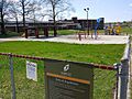
Playground equipment at North Harford Park in 2021
-
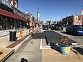
Floating bus stop and separated bike lane on Harford Road at Hamilton Avenue in 2020
-

Lake Montebello reservoir in 2019
